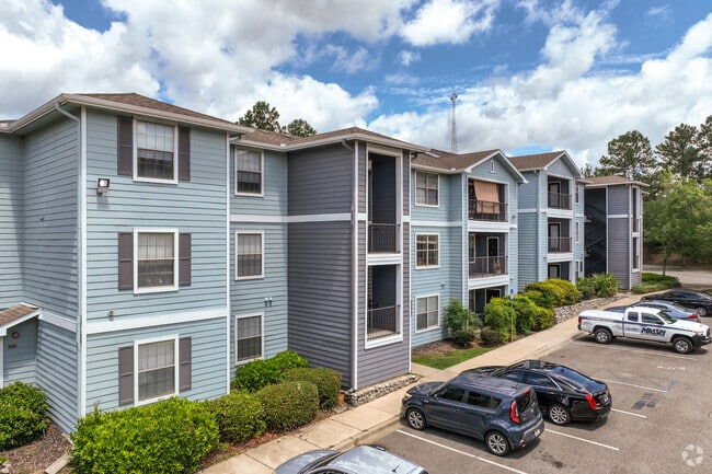
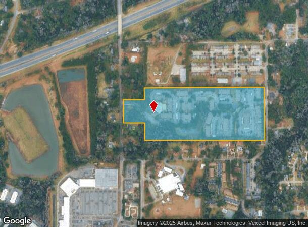
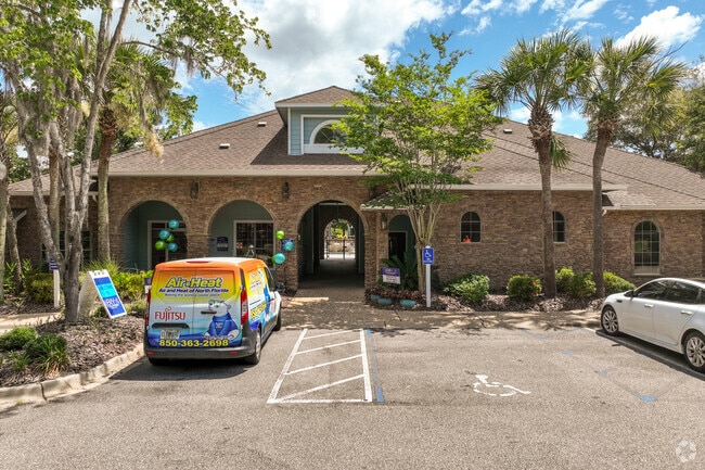
Property Record
2915 Sharer Rd, Tallahassee, FL 32312
NEARBY LISTINGS FOR SALE OR LEASE
Property Detail
2915 Sharer Rd
21-13-20-622-000.0
Unplatted Land
Multifamilydwelling
13 & 14 1N 1W IN SW 1/4 SECT 13 AND IN NE 1/4 OF SE 1/4 SECT 14 OR 594/484 2384/2376
X
Leon
12073C0281F
Florida
2025
28.06 AC
2025
Northwest Tallahassee
001601
Tallahassee
325,451 SF
Tallahassee, FL
DEMOGRAPHICS near 2915 Sharer Rd
1 Mile
3 Mile
5 Mile
2024 Total Population
7,069
70,459
160,863
2029 Population
7,536
73,656
168,493
Pop Growth 2024-2029
+ 6.61%
+ 4.54%
+ 4.74%
Average Age
37
35
35
2024 Total Households
3,096
30,816
69,173
HH Growth 2024-2029
+ 6.88%
+ 4.77%
+ 4.97%
Median Household Inc
$55,265
$48,489
$47,466
Avg Household Size
2.20
2.10
2.10
2024 Avg HH Vehicles
1.00
2.00
2.00
Median Home Value
$216,806
$244,791
$236,331
Median Year Built
1985
1980
1984
Nearby Places
Map Layers
Map Styles
 Street
 Aerial
- Restaurants
- Banks
- Shops
- Fitness
- Groceries
PUBLIC TRANSPORTATION
AIRPORT
Tallahassee International
DRIVE
WALK
Distance
Tallahassee International
20 min
11.2 mi
Freight Ports
Port of Panama City
DRIVE
WALK
Distance
Port of Panama City
140 min
104.4 mi
Nearby Properties
Address
Land Use
TOTAL SIZE
Lot Size
Zoning
Address
Land Use
TOTAL SIZE
Lot Size
Zoning
6,686,582 SF
86.50 AC
UT
Address
Land Use
TOTAL SIZE
Lot Size
Zoning
4,577,528 SF
108.47 AC
UT
Address
Land Use
TOTAL SIZE
Lot Size
Zoning
3,647,358 SF
49.17 AC
UT
Address
Land Use
TOTAL SIZE
Lot Size
Zoning
3,882,850 SF
22.64 AC
CM
Address
Land Use
TOTAL SIZE
Lot Size
Zoning
859,455 SF
3.79 AC
CU45
Address
Land Use
TOTAL SIZE
Lot Size
Zoning
367,978 SF
2.52 AC
RO
Address
Land Use
TOTAL SIZE
Lot Size
Zoning
664,514 SF
2.49 AC
UT
Address
Land Use
TOTAL SIZE
Lot Size
Zoning
369,383 SF
4.51 AC
UT
Address
Land Use
TOTAL SIZE
Lot Size
Zoning
414,216 SF
2.23 AC
CU45
Address
Land Use
TOTAL SIZE
Lot Size
Zoning
531,932 SF
2.58 AC
DI
Address
Land Use
TOTAL SIZE
Lot Size
Zoning
538,290 SF
11.05 AC
Address
Land Use
TOTAL SIZE
Lot Size
Zoning
851,869 SF
5.15 AC
DI
Address
Land Use
TOTAL SIZE
Lot Size
Zoning
169,758 SF
1.71 AC
RO
Address
Land Use
TOTAL SIZE
Lot Size
Zoning
225,370 SF
3.76 AC
CU45
Address
Land Use
TOTAL SIZE
Lot Size
Zoning
459,568 SF
10.10 AC
CU45
Address
Land Use
TOTAL SIZE
Lot Size
Zoning
883,293 SF
35.97 AC
R4
Address
Land Use
TOTAL SIZE
Lot Size
Zoning
607,000 SF
37.55 AC
PUD
Address
Land Use
TOTAL SIZE
Lot Size
Zoning
1,241,812 SF
44.71 AC
MR1
Address
Land Use
TOTAL SIZE
Lot Size
Zoning
423,131 SF
8.36 AC
CU45
Address
Land Use
TOTAL SIZE
Lot Size
Zoning
1,048,414 SF
5.88 AC
UT
Address
Land Use
TOTAL SIZE
Lot Size
Zoning
489,720 SF
2.07 AC
UPUD
Address
Land Use
TOTAL SIZE
Lot Size
Zoning
338,790 SF
16 AC
PUD
Address
Land Use
TOTAL SIZE
Lot Size
Zoning
325,725 SF
2.44 AC
UPUD
Address
Land Use
TOTAL SIZE
Lot Size
Zoning
498,076 SF
22.49 AC
MR1
Address
Land Use
TOTAL SIZE
Lot Size
Zoning
96,444 SF
16.70 AC
UT
Address
Land Use
TOTAL SIZE
Lot Size
Zoning
234,117 SF
5.85 AC
UT
Address
Land Use
TOTAL SIZE
Lot Size
Zoning
147,000 SF
2.16 AC
UT
Address
Land Use
TOTAL SIZE
Lot Size
Zoning
196,915 SF
3.33 AC
UT
Address
Land Use
TOTAL SIZE
Lot Size
Zoning
88,230 SF
2.22 AC
RO
The World's #1 Commercial Real Estate Marketplace
Connect with us
© 2026 CoStar Group
The information above has been obtained from sources believed reliable. While we do not doubt its accuracy we have not verified it and make no guarantee, warranty or representation about it. It is your responsibility to independently confirm its accuracy and completeness. Any projections, opinions, assumptions, or estimates used are for example only and do not represent the current or future performance of the property. The value of this transaction to you depends on tax and other factors which should be evaluated by your tax, financial, and legal advisors. You and your advisors should conduct a careful, independent investigation of the property to determine to your satisfaction the suitability of the property for your needs.