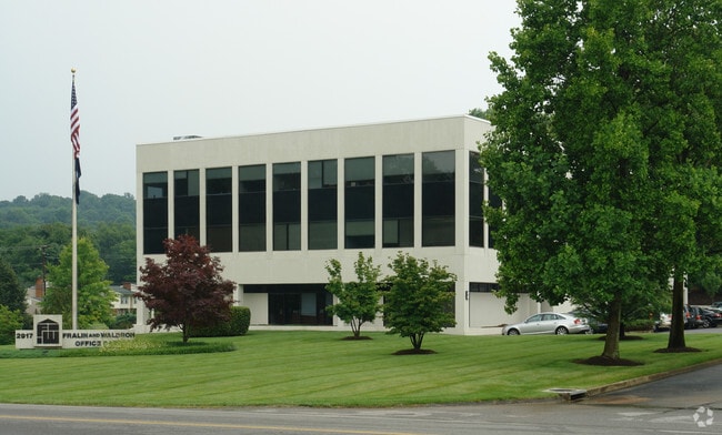
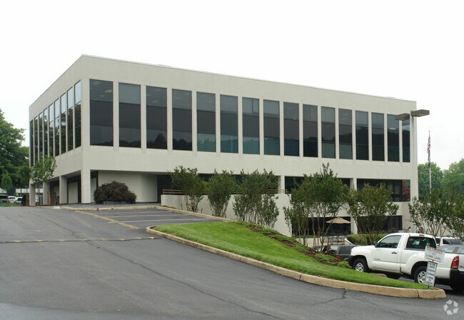
Property Record
2917 Penn Forest Blvd, Roanoke, VA 24018

NEARBY LISTINGS FOR SALE OR LEASE
Property Detail
2917 Penn Forest Blvd
087.06-04-06
Tanglewood Commercial Ii
Officebuilding
MURRAYS RUN
X
Roanoke
51067C0055C
Virginia
2025
2.83 AC
2025
Southwest Roanoke
030803
Roanoke
38,095 SF
Roanoke, VA
DEMOGRAPHICS near 2917 Penn Forest Blvd
1 mile
3 mile
5 mile
2024 Total Population
9,130
49,389
102,659
2029 Population
9,177
48,862
101,489
Pop Growth 2024-2029
+ 0.51%
(1.07%)
(1.14%)
Average Age
41
43
42
2024 Total Households
4,192
22,138
45,469
HH Growth 2024-2029
+ 0.50%
(1.15%)
(1.16%)
Median Household Inc
$71,569
$74,843
$59,506
Avg Household Size
2.20
2.20
2.20
2024 Avg HH Vehicles
2.00
2.00
2.00
Median Home Value
$222,449
$270,994
$242,227
Median Year Built
1978
1972
1967
Nearby Places
Map Layers
Map Styles
 Street
 Aerial
Transit
 Traffic
 Biking
Places
Listings with unknown addresses are not visible on the map
- Restaurants
- Banks
- Shops
- Fitness
- Groceries
PUBLIC TRANSPORTATION
AIRPORT
Roanoke/Blacksburg Regional (Woodrum Field)
Drive
Walk
Distance
Roanoke/Blacksburg Regional (Woodrum Field)
20 min
10.9 mi
Nearby Properties
Address
Land Use
TOTAL SIZE
Lot Size
Zoning
Address
Land Use
TOTAL SIZE
Lot Size
Zoning
41,443 SF
96.33 AC
INPUD
Address
Land Use
TOTAL SIZE
Lot Size
Zoning
47,181 SF
33.94 AC
INPUD
Address
Land Use
TOTAL SIZE
Lot Size
Zoning
19,734 SF
34.83 AC
INPUD
Address
Land Use
TOTAL SIZE
Lot Size
Zoning
177,095 SF
18.55 AC
RMF
Address
Land Use
TOTAL SIZE
Lot Size
Zoning
138,261 SF
22.24 AC
CLS
Address
Land Use
TOTAL SIZE
Lot Size
Zoning
136,331 SF
29.73 AC
C1
Address
Land Use
TOTAL SIZE
Lot Size
Zoning
59,641 SF
5.63 AC
INPUD
Address
Land Use
TOTAL SIZE
Lot Size
Zoning
180,301 SF
56.16 AC
R1S
Address
Land Use
TOTAL SIZE
Lot Size
Zoning
149,370 SF
40 AC
R1
Address
Land Use
TOTAL SIZE
Lot Size
Zoning
7,279 SF
24.35 AC
R3C
Address
Land Use
TOTAL SIZE
Lot Size
Zoning
10,030 SF
32.18 AC
RMF
Address
Land Use
TOTAL SIZE
Lot Size
Zoning
32,814 SF
18.14 AC
C1
Address
Land Use
TOTAL SIZE
Lot Size
Zoning
6.29 AC
MXPUD
Address
Land Use
TOTAL SIZE
Lot Size
Zoning
10,143 SF
25.30 AC
R3
Address
Land Use
TOTAL SIZE
Lot Size
Zoning
2.75 AC
Address
Land Use
TOTAL SIZE
Lot Size
Zoning
6,298 SF
43.38 AC
C2
Address
Land Use
TOTAL SIZE
Lot Size
Zoning
42,128 SF
32.68 AC
INPUD
Address
Land Use
TOTAL SIZE
Lot Size
Zoning
118,647 SF
1.88 AC
IN
Address
Land Use
TOTAL SIZE
Lot Size
Zoning
146,345 SF
5.97 AC
MX
Address
Land Use
TOTAL SIZE
Lot Size
Zoning
56,496 SF
19.14 AC
I2C
Address
Land Use
TOTAL SIZE
Lot Size
Zoning
10,713 SF
12.44 AC
R3
Address
Land Use
TOTAL SIZE
Lot Size
Zoning
187,130 SF
29.96 AC
C2
Address
Land Use
TOTAL SIZE
Lot Size
Zoning
11,529 SF
9.78 AC
R4
Address
Land Use
TOTAL SIZE
Lot Size
Zoning
583 SF
7.16 AC
INPUD
Address
Land Use
TOTAL SIZE
Lot Size
Zoning
11,529 SF
9.75 AC
R4
Address
Land Use
TOTAL SIZE
Lot Size
Zoning
7.75 AC
Address
Land Use
TOTAL SIZE
Lot Size
Zoning
71,400 SF
10.24 AC
R1
Address
Land Use
TOTAL SIZE
Lot Size
Zoning
9,360 SF
20.34 AC
R4
Address
Land Use
TOTAL SIZE
Lot Size
Zoning
10,143 SF
10.33 AC
R4
Address
Land Use
TOTAL SIZE
Lot Size
Zoning
61,198 SF
7.30 AC
I-1
The World's #1 Commercial Real Estate Marketplace
Connect with us
© 2026 CoStar Group
The information above has been obtained from sources believed reliable. While we do not doubt its accuracy we have not verified it and make no guarantee, warranty or representation about it. It is your responsibility to independently confirm its accuracy and completeness. Any projections, opinions, assumptions, or estimates used are for example only and do not represent the current or future performance of the property. The value of this transaction to you depends on tax and other factors which should be evaluated by your tax, financial, and legal advisors. You and your advisors should conduct a careful, independent investigation of the property to determine to your satisfaction the suitability of the property for your needs.