Property Record
2918 E Main Rd, Portsmouth, RI 02871
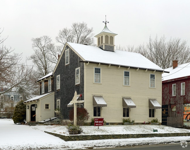

Property Detail
2918 E Main Rd
Commercialbuilding
Newport
C
Rhode Island
B and X Area of moderate flood hazard, usually the area between the limits of the 100-year and 500-year floods.
0.25 AC
2025
Newport County
2025
Providence
040102
Providence-Warwick, RI-MA
2,150 SF
PORT-000031-000000-000018
NEARBY LISTINGS FOR SALE OR LEASE
DEMOGRAPHICS near 2918 E Main Rd
1 mile
3 mile
5 mile
2025 Total Population
3,133
14,031
34,246
2030 Population
3,005
13,478
32,951
Pop Growth 2025-2030
(4.09%)
(3.94%)
(3.78%)
Average Age
47
47
45
2025 Total Households
1,273
5,685
13,801
HH Growth 2025-2030
(3.22%)
(3.13%)
(3.18%)
Median Household Inc
$133,564
$130,347
$110,723
Avg Household Size
2.40
2.40
2.30
2025 Avg HH Vehicles
2.00
2.00
2.00
Median Home Value
$703,097
$694,151
$643,040
Median Year Built
1968
1966
1963
Nearby Places
Map Layers
Map Styles
 Street
 Aerial
Layers
 Traffic
 Biking
Places
Listings with unknown addresses are not visible on the map
- Restaurants
- Banks
- Shops
- Fitness
- Groceries
PUBLIC TRANSPORTATION
AIRPORT
Rhode Island Tf Green International
Drive
Walk
Distance
Rhode Island Tf Green International
48 min
28.7 mi
Freight Ports
Port of New Bedford Harbor
Drive
Walk
Distance
Port of New Bedford Harbor
30 min
21.6 mi
SALE & LEASE HISTORY
LISTING DATE
SALE/LEASE

Oct 15, 2021
For Lease
Jul 20, 2021
For Sale
Aug 20, 2018
For Lease
Nearby Properties
Address
Land Use
TOTAL SIZE
Lot Size
Zoning
Address
Land Use
TOTAL SIZE
Lot Size
Zoning
42 AC
R20
Address
Land Use
TOTAL SIZE
Lot Size
Zoning
13,478 SF
1 AC
HI
Address
Land Use
TOTAL SIZE
Lot Size
Zoning
9.01 AC
R20
Address
Land Use
TOTAL SIZE
Lot Size
Zoning
23.78 AC
WD
Address
Land Use
TOTAL SIZE
Lot Size
Zoning
16 AC
WD
Address
Land Use
TOTAL SIZE
Lot Size
Zoning
Address
Land Use
TOTAL SIZE
Lot Size
Zoning
6 AC
HI
Address
Land Use
TOTAL SIZE
Lot Size
Zoning
74,293 SF
10.77 AC
TC
Address
Land Use
TOTAL SIZE
Lot Size
Zoning
367.97 AC
OS
Address
Land Use
TOTAL SIZE
Lot Size
Zoning
44,815 SF
5 AC
R20
Address
Land Use
TOTAL SIZE
Lot Size
Zoning
48,351 SF
10.75 AC
R20
Address
Land Use
TOTAL SIZE
Lot Size
Zoning
44.80 AC
R20
Address
Land Use
TOTAL SIZE
Lot Size
Zoning
1 AC
R60
Address
Land Use
TOTAL SIZE
Lot Size
Zoning
60,480 SF
3.88 AC
R20
Address
Land Use
TOTAL SIZE
Lot Size
Zoning
5.85 AC
LI
Address
Land Use
TOTAL SIZE
Lot Size
Zoning
78,182 SF
10 AC
R10
Address
Land Use
TOTAL SIZE
Lot Size
Zoning
10.46 AC
R20
Address
Land Use
TOTAL SIZE
Lot Size
Zoning
33,916 SF
5.75 AC
TC
Address
Land Use
TOTAL SIZE
Lot Size
Zoning
244 AC
R60/HI
Address
Land Use
TOTAL SIZE
Lot Size
Zoning
2.79 AC
R10
Address
Land Use
TOTAL SIZE
Lot Size
Zoning
R60/HI
Address
Land Use
TOTAL SIZE
Lot Size
Zoning
2.81 AC
C
Address
Land Use
TOTAL SIZE
Lot Size
Zoning
18,773 SF
1 AC
R60
Address
Land Use
TOTAL SIZE
Lot Size
Zoning
13.80 AC
R20
Address
Land Use
TOTAL SIZE
Lot Size
Zoning
7,179 SF
9.50 AC
R-40
Address
Land Use
TOTAL SIZE
Lot Size
Zoning
4.50 AC
R20
Address
Land Use
TOTAL SIZE
Lot Size
Zoning
48,718 SF
5 AC
LI
Address
Land Use
TOTAL SIZE
Lot Size
Zoning
4.56 AC
WD
Address
Land Use
TOTAL SIZE
Lot Size
Zoning
35,250 SF
R30
Address
Land Use
TOTAL SIZE
Lot Size
Zoning
107.70 AC
R10
The World's #1 Commercial Real Estate Marketplace
Connect with us
© 2026 CoStar Group
The information above has been obtained from sources believed reliable. While we do not doubt its accuracy we have not verified it and make no guarantee, warranty or representation about it. It is your responsibility to independently confirm its accuracy and completeness. Any projections, opinions, assumptions, or estimates used are for example only and do not represent the current or future performance of the property. The value of this transaction to you depends on tax and other factors which should be evaluated by your tax, financial, and legal advisors. You and your advisors should conduct a careful, independent investigation of the property to determine to your satisfaction the suitability of the property for your needs.