Property Record
2919 Joe Dimaggio Blvd, Round Rock, TX 78665

Property Detail
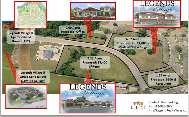
2919 Joe Dimaggio Blvd
Austin-Round Rock-San Marcos, TX
S8280 - LEGENDS VILLAGE SEC 3 (LT 1 BLK B REPLAT), BLOCK B, LOT 1A, ACRES 2.5
R442319
Williamson
Taxexempt
Texas
PUD
1,1a
B and X Area of moderate flood hazard, usually the area between the limits of the 100-year and 500-year floods.
2.50 AC
2023
Round Rock
2025
Austin
021512
NEARBY LISTINGS FOR SALE OR LEASE
DEMOGRAPHICS near 2919 Joe Dimaggio Blvd
1 mile
3 mile
5 mile
2024 Total Population
8,920
104,034
240,336
2029 Population
10,199
117,878
269,734
Pop Growth 2024-2029
+ 14.34%
+ 13.31%
+ 12.23%
Average Age
36
36
37
2024 Total Households
3,195
37,215
87,512
HH Growth 2024-2029
+ 14.80%
+ 13.80%
+ 12.82%
Median Household Inc
$95,896
$97,753
$110,728
Avg Household Size
2.80
2.70
2.70
2024 Avg HH Vehicles
2.00
2.00
2.00
Median Home Value
$458,737
$422,225
$436,662
Median Year Built
2005
2003
2006
Nearby Places
Map Layers
Map Styles
 Street
 Aerial
Transit
 Traffic
 Biking
Places
Listings with unknown addresses are not visible on the map
- Restaurants
- Banks
- Shops
- Fitness
- Groceries
PUBLIC TRANSPORTATION
AIRPORT
Austin-Bergstrom International
Drive
Walk
Distance
Austin-Bergstrom International
46 min
35.5 mi
SALE & LEASE HISTORY
LISTING DATE
SALE/LEASE

Dec 18, 2017
For Lease
Nearby Properties
Address
Land Use
TOTAL SIZE
Lot Size
Zoning
Address
Land Use
TOTAL SIZE
Lot Size
Zoning
1,240,638 SF
171.60 AC
Address
Land Use
TOTAL SIZE
Lot Size
Zoning
2,089,779 SF
167.49 AC
Address
Land Use
TOTAL SIZE
Lot Size
Zoning
422,682 SF
95.18 AC
Address
Land Use
TOTAL SIZE
Lot Size
Zoning
485,021 SF
50.17 AC
C1
Address
Land Use
TOTAL SIZE
Lot Size
Zoning
345,000 SF
48.61 AC
Address
Land Use
TOTAL SIZE
Lot Size
Zoning
533,151 SF
26.90 AC
PUD
Address
Land Use
TOTAL SIZE
Lot Size
Zoning
445,321 SF
12.52 AC
Address
Land Use
TOTAL SIZE
Lot Size
Zoning
273,462 SF
47.12 AC
Address
Land Use
TOTAL SIZE
Lot Size
Zoning
456,943 SF
66.31 AC
SF2
Address
Land Use
TOTAL SIZE
Lot Size
Zoning
361,440 SF
19.35 AC
Address
Land Use
TOTAL SIZE
Lot Size
Zoning
618,605 SF
14.11 AC
PUD
Address
Land Use
TOTAL SIZE
Lot Size
Zoning
326,015 SF
11.11 AC
Address
Land Use
TOTAL SIZE
Lot Size
Zoning
201,200 SF
9.48 AC
Address
Land Use
TOTAL SIZE
Lot Size
Zoning
140,409 SF
17.15 AC
Address
Land Use
TOTAL SIZE
Lot Size
Zoning
330,541 SF
20.90 AC
PUD
Address
Land Use
TOTAL SIZE
Lot Size
Zoning
364,432 SF
20.56 AC
MF
Address
Land Use
TOTAL SIZE
Lot Size
Zoning
285,835 SF
25.69 AC
C1
Address
Land Use
TOTAL SIZE
Lot Size
Zoning
344,341 SF
19.19 AC
PUD
Address
Land Use
TOTAL SIZE
Lot Size
Zoning
409,875 SF
25.28 AC
MF
Address
Land Use
TOTAL SIZE
Lot Size
Zoning
330,300 SF
18.58 AC
C1
Address
Land Use
TOTAL SIZE
Lot Size
Zoning
375,523 SF
15.43 AC
PUD
Address
Land Use
TOTAL SIZE
Lot Size
Zoning
217,013 SF
20.44 AC
Address
Land Use
TOTAL SIZE
Lot Size
Zoning
326,218 SF
44.54 AC
Address
Land Use
TOTAL SIZE
Lot Size
Zoning
364,797 SF
13.50 AC
Address
Land Use
TOTAL SIZE
Lot Size
Zoning
236,046 SF
9.77 AC
Address
Land Use
TOTAL SIZE
Lot Size
Zoning
234,510 SF
19.18 AC
Address
Land Use
TOTAL SIZE
Lot Size
Zoning
220,792 SF
11.31 AC
Address
Land Use
TOTAL SIZE
Lot Size
Zoning
112.40 AC
PF3
Address
Land Use
TOTAL SIZE
Lot Size
Zoning
276,364 SF
12.33 AC
PUD
Address
Land Use
TOTAL SIZE
Lot Size
Zoning
315,884 SF
15.05 AC
The World's #1 Commercial Real Estate Marketplace
Connect with us
© 2026 CoStar Group
The information above has been obtained from sources believed reliable. While we do not doubt its accuracy we have not verified it and make no guarantee, warranty or representation about it. It is your responsibility to independently confirm its accuracy and completeness. Any projections, opinions, assumptions, or estimates used are for example only and do not represent the current or future performance of the property. The value of this transaction to you depends on tax and other factors which should be evaluated by your tax, financial, and legal advisors. You and your advisors should conduct a careful, independent investigation of the property to determine to your satisfaction the suitability of the property for your needs.