Property Record
2919 N Main St, Mansfield, TX 76063

Save to a Folder
{{folder.Name}}
{{folder.ListingIds.length}} Properties
{{folder.ListingIds.length}} Property
Create a New Folder
Property Detail
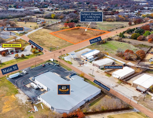
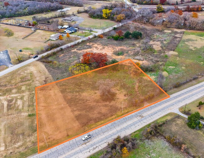
2919 N Main St
Dallas-Fort Worth-Arlington, TX
HEDENBERG, ABRAM D SURVEY ABSTRACT 725 TRACT 3D
04495845
TARRANT
Residentialacreage
Texas
B and X Area of moderate flood hazard, usually the area between the limits of the 100-year and 500-year floods.
0.61 AC
2025
Southeast Ft Worth
2025
Dallas/Ft Worth
111408
NEARBY LISTINGS FOR SALE OR LEASE
DEMOGRAPHICS near 2919 N Main St
1 mile
3 mile
5 mile
2025 Total Population
2,825
46,962
172,172
2030 Population
3,014
49,719
180,994
Pop Growth 2025-2030
+ 6.69%
+ 5.87%
+ 5.12%
Average Age
40
39
39
2025 Total Households
939
16,333
59,541
HH Growth 2025-2030
+ 6.82%
+ 6.07%
+ 5.29%
Median Household Inc
$112,500
$108,428
$99,211
Avg Household Size
3.00
2.80
2.80
2025 Avg HH Vehicles
2.00
2.00
2.00
Median Home Value
$416,360
$394,238
$359,124
Median Year Built
2004
2000
1994
Nearby Places
Map Layers
Map Styles
 Street
 Aerial
Layers
 Traffic
 Biking
Places
Listings with unknown addresses are not visible on the map
- Restaurants
- Banks
- Shops
- Fitness
- Groceries
PUBLIC TRANSPORTATION
AIRPORT
Dallas-Fort Worth International
Drive
Walk
Distance
Dallas-Fort Worth International
43 min
31.7 mi
Dallas Love Field
Drive
Walk
Distance
Dallas Love Field
52 min
39.0 mi
Freight Ports
Port of Shreveport
Drive
Walk
Distance
Port of Shreveport
243 min
224.7 mi
Nearby Properties
Address
Land Use
TOTAL SIZE
Lot Size
Zoning
Address
Land Use
TOTAL SIZE
Lot Size
Zoning
348,951 SF
18.66 AC
Address
Land Use
TOTAL SIZE
Lot Size
Zoning
160,000 SF
26.90 AC
Address
Land Use
TOTAL SIZE
Lot Size
Zoning
298,988 SF
7.16 AC
Address
Land Use
TOTAL SIZE
Lot Size
Zoning
249,922 SF
17.26 AC
Address
Land Use
TOTAL SIZE
Lot Size
Zoning
256,088 SF
10.27 AC
Address
Land Use
TOTAL SIZE
Lot Size
Zoning
170,082 SF
36.49 AC
Address
Land Use
TOTAL SIZE
Lot Size
Zoning
208,630 SF
8.62 AC
Address
Land Use
TOTAL SIZE
Lot Size
Zoning
214,444 SF
17.45 AC
Address
Land Use
TOTAL SIZE
Lot Size
Zoning
231,551 SF
25.69 AC
Address
Land Use
TOTAL SIZE
Lot Size
Zoning
234,580 SF
65.82 AC
Address
Land Use
TOTAL SIZE
Lot Size
Zoning
167,643 SF
8.99 AC
Address
Land Use
TOTAL SIZE
Lot Size
Zoning
169,347 SF
13.92 AC
Address
Land Use
TOTAL SIZE
Lot Size
Zoning
229,168 SF
6.13 AC
Address
Land Use
TOTAL SIZE
Lot Size
Zoning
149,494 SF
3.73 AC
Address
Land Use
TOTAL SIZE
Lot Size
Zoning
79,070 SF
11.98 AC
Address
Land Use
TOTAL SIZE
Lot Size
Zoning
268,603 SF
12.45 AC
Address
Land Use
TOTAL SIZE
Lot Size
Zoning
238,119 SF
7.52 AC
Address
Land Use
TOTAL SIZE
Lot Size
Zoning
275,337 SF
14 AC
Address
Land Use
TOTAL SIZE
Lot Size
Zoning
85,786 SF
9.43 AC
Address
Land Use
TOTAL SIZE
Lot Size
Zoning
81,540 SF
11.89 AC
Address
Land Use
TOTAL SIZE
Lot Size
Zoning
80,907 SF
29 AC
Address
Land Use
TOTAL SIZE
Lot Size
Zoning
44,669 SF
9.05 AC
Address
Land Use
TOTAL SIZE
Lot Size
Zoning
77,884 SF
30.70 AC
Address
Land Use
TOTAL SIZE
Lot Size
Zoning
98,332 SF
3.27 AC
Address
Land Use
TOTAL SIZE
Lot Size
Zoning
70,636 SF
15.08 AC
Address
Land Use
TOTAL SIZE
Lot Size
Zoning
127,690 SF
37.21 AC
Address
Land Use
TOTAL SIZE
Lot Size
Zoning
22.84 AC
Address
Land Use
TOTAL SIZE
Lot Size
Zoning
156,103 SF
4.42 AC
Address
Land Use
TOTAL SIZE
Lot Size
Zoning
41,960 SF
13.70 AC
Address
Land Use
TOTAL SIZE
Lot Size
Zoning
36,962 SF
3.69 AC
The World's #1 Commercial Real Estate Marketplace
Connect with us
© 2026 CoStar Group
The information above has been obtained from sources believed reliable. While we do not doubt its accuracy we have not verified it and make no guarantee, warranty or representation about it. It is your responsibility to independently confirm its accuracy and completeness. Any projections, opinions, assumptions, or estimates used are for example only and do not represent the current or future performance of the property. The value of this transaction to you depends on tax and other factors which should be evaluated by your tax, financial, and legal advisors. You and your advisors should conduct a careful, independent investigation of the property to determine to your satisfaction the suitability of the property for your needs.