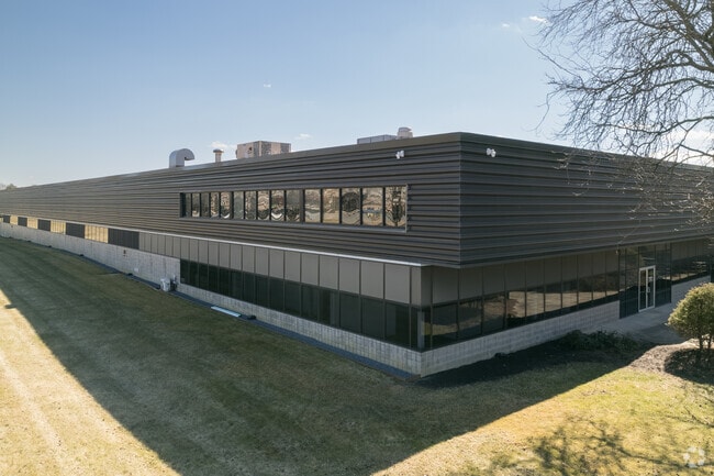
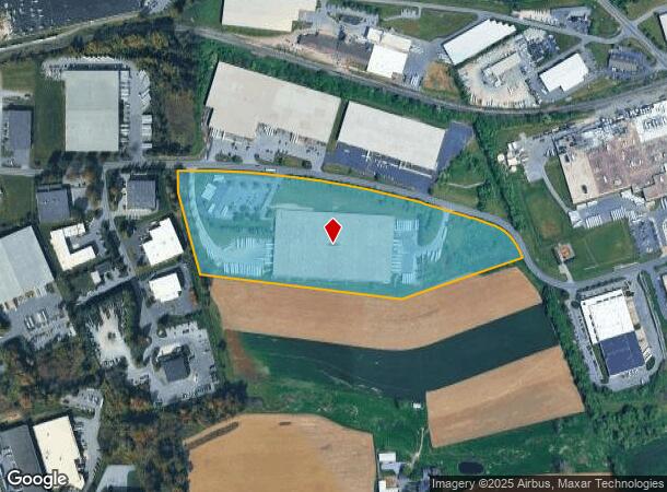
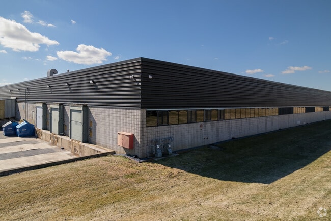
Property Record
2919 Old Tree Dr, Lancaster, PA 17603
NEARBY LISTINGS FOR SALE OR LEASE
Property Detail
2919 Old Tree Dr
Lancaster, PA
30 West Indust Park Sec 02
290-34620-0-0000
2919 OLD TREE DR
Lightindustrial
Lancaster
X
Pennsylvania
42071C0342F
5
2024
20.90 AC
2025
Lancaster County
011701
Philadelphia
240,609 SF
DEMOGRAPHICS near 2919 Old Tree Dr
1 Mile
3 Mile
5 Mile
2024 Total Population
4,832
50,057
165,886
2029 Population
4,897
50,292
167,121
Pop Growth 2024-2029
+ 1.35%
+ 0.47%
+ 0.74%
Average Age
43
43
39
2024 Total Households
2,021
19,863
63,269
HH Growth 2024-2029
+ 1.34%
+ 0.35%
+ 0.69%
Median Household Inc
$67,253
$87,442
$73,953
Avg Household Size
2.40
2.40
2.40
2024 Avg HH Vehicles
2.00
2.00
2.00
Median Home Value
$252,798
$264,589
$236,160
Median Year Built
1968
1982
1968
Nearby Places
Map Layers
Map Styles
 Street
 Aerial
- Restaurants
- Banks
- Shops
- Fitness
- Groceries
PUBLIC TRANSPORTATION
COMMUTER RAIL
DRIVE
WALK
Distance
12 min
6.4 mi
DRIVE
WALK
Distance
18 min
9.8 mi
AIRPORT
Harrisburg International
DRIVE
WALK
Distance
Harrisburg International
42 min
30.3 mi
Freight Ports
Port Newark Container Terminal
DRIVE
WALK
Distance
Port Newark Container Terminal
84 min
49.7 mi
SALE & LEASE HISTORY
LISTING DATE
SALE/LEASE

Nov 16, 2020
For Lease
Feb 15, 2019
For Lease
Nearby Properties
Address
Land Use
TOTAL SIZE
Lot Size
Zoning
Address
Land Use
TOTAL SIZE
Lot Size
Zoning
822,920 SF
97.54 AC
HCD
Address
Land Use
TOTAL SIZE
Lot Size
Zoning
1,603,151 SF
104.89 AC
C3
Address
Land Use
TOTAL SIZE
Lot Size
Zoning
526,898 SF
26.10 AC
AH
Address
Land Use
TOTAL SIZE
Lot Size
Zoning
1,003,686 SF
127.66 AC
HR
Address
Land Use
TOTAL SIZE
Lot Size
Zoning
243,960 SF
39.27 AC
Address
Land Use
TOTAL SIZE
Lot Size
Zoning
941,905 SF
141.50 AC
I
Address
Land Use
TOTAL SIZE
Lot Size
Zoning
905,200 SF
68.60 AC
Address
Land Use
TOTAL SIZE
Lot Size
Zoning
224,054 SF
71 AC
Address
Land Use
TOTAL SIZE
Lot Size
Zoning
308,727 SF
11.37 AC
Address
Land Use
TOTAL SIZE
Lot Size
Zoning
193,864 SF
9 AC
Address
Land Use
TOTAL SIZE
Lot Size
Zoning
269,890 SF
57.10 AC
SR
Address
Land Use
TOTAL SIZE
Lot Size
Zoning
135,998 SF
28.64 AC
HR
Address
Land Use
TOTAL SIZE
Lot Size
Zoning
621,413 SF
79.20 AC
I-1
Address
Land Use
TOTAL SIZE
Lot Size
Zoning
691,290 SF
3 AC
Address
Land Use
TOTAL SIZE
Lot Size
Zoning
372,708 SF
50.40 AC
HR
Address
Land Use
TOTAL SIZE
Lot Size
Zoning
128,939 SF
27.39 AC
Address
Land Use
TOTAL SIZE
Lot Size
Zoning
101,558 SF
28.14 AC
AH
Address
Land Use
TOTAL SIZE
Lot Size
Zoning
199,107 SF
26.20 AC
CC
Address
Land Use
TOTAL SIZE
Lot Size
Zoning
138,618 SF
9.53 AC
Address
Land Use
TOTAL SIZE
Lot Size
Zoning
385,561 SF
27.20 AC
Address
Land Use
TOTAL SIZE
Lot Size
Zoning
299,600 SF
63 AC
HR
Address
Land Use
TOTAL SIZE
Lot Size
Zoning
244,568 SF
8.30 AC
IN
Address
Land Use
TOTAL SIZE
Lot Size
Zoning
718,859 SF
39.80 AC
I-2
Address
Land Use
TOTAL SIZE
Lot Size
Zoning
1,382,541 SF
106.20 AC
Address
Land Use
TOTAL SIZE
Lot Size
Zoning
113,967 SF
13.32 AC
Address
Land Use
TOTAL SIZE
Lot Size
Zoning
75,766 SF
9.07 AC
Address
Land Use
TOTAL SIZE
Lot Size
Zoning
826,042 SF
57.40 AC
CM
Address
Land Use
TOTAL SIZE
Lot Size
Zoning
97,158 SF
16.55 AC
R-2
Address
Land Use
TOTAL SIZE
Lot Size
Zoning
158,689 SF
25.40 AC
B-4
Address
Land Use
TOTAL SIZE
Lot Size
Zoning
237,347 SF
15.88 AC
I-1
The World's #1 Commercial Real Estate Marketplace
Connect with us
© 2025 CoStar Group
The information above has been obtained from sources believed reliable. While we do not doubt its accuracy we have not verified it and make no guarantee, warranty or representation about it. It is your responsibility to independently confirm its accuracy and completeness. Any projections, opinions, assumptions, or estimates used are for example only and do not represent the current or future performance of the property. The value of this transaction to you depends on tax and other factors which should be evaluated by your tax, financial, and legal advisors. You and your advisors should conduct a careful, independent investigation of the property to determine to your satisfaction the suitability of the property for your needs.