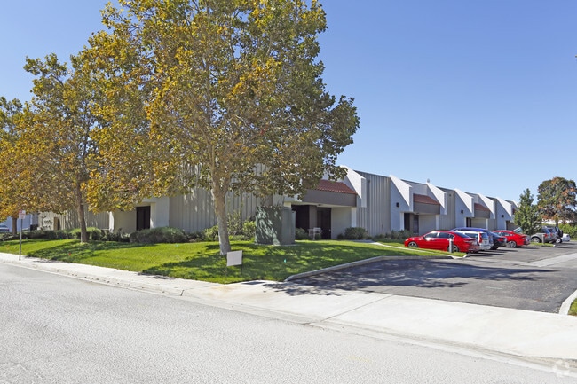
Property Record
2919 Union Rd, Paso Robles, CA 93446

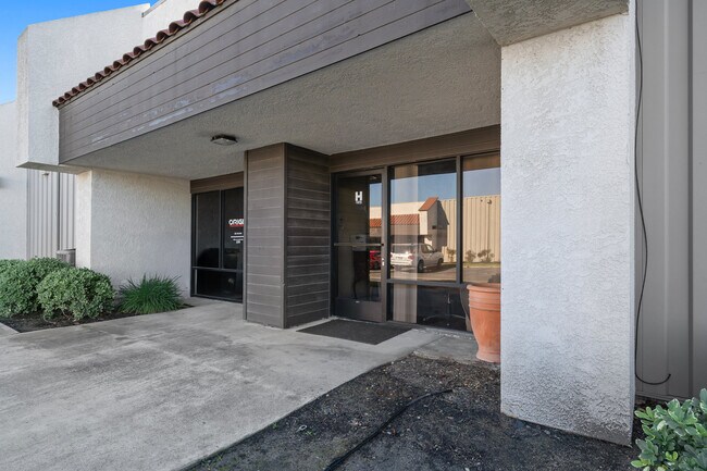

Current Lease Availabilities
Property Detail
2919 Union Rd
025-403-045
PM 43-58 PAR 3
Multipleuses
San Luis Obispo
C3
California
B and X Area of moderate flood hazard, usually the area between the limits of the 100-year and 500-year floods.
3
2024
1.12 AC
2025
North 101 Corridor
010207
San Luis Obispo/Paso Robles
20,000 SF
San Luis Obispo-Paso Robles, CA
NEARBY LISTINGS FOR SALE OR LEASE
DEMOGRAPHICS near 2919 Union Rd
1 mile
3 mile
5 mile
2024 Total Population
1,953
31,208
36,038
2029 Population
1,950
30,954
35,689
Pop Growth 2024-2029
(0.15%)
(0.81%)
(0.97%)
Average Age
43
40
40
2024 Total Households
700
11,467
13,222
HH Growth 2024-2029
(0.43%)
(0.99%)
(1.15%)
Median Household Inc
$121,110
$89,860
$93,765
Avg Household Size
2.70
2.70
2.70
2024 Avg HH Vehicles
2.00
2.00
2.00
Median Home Value
$771,570
$719,610
$731,564
Median Year Built
1997
1986
1987
Nearby Places
Map Layers
Map Styles
 Street
 Aerial
Transit
 Traffic
 Biking
Places
Listings with unknown addresses are not visible on the map
- Restaurants
- Banks
- Shops
- Fitness
- Groceries
PUBLIC TRANSPORTATION
COMMUTER RAIL
Drive
Walk
Distance
6 min
2.8 mi
AIRPORT
San Luis County Regional
Drive
Walk
Distance
San Luis County Regional
50 min
37.2 mi
Nearby Properties
Address
Land Use
TOTAL SIZE
Lot Size
Zoning
Address
Land Use
TOTAL SIZE
Lot Size
Zoning
197,140 SF
11.87 AC
R3
Address
Land Use
TOTAL SIZE
Lot Size
Zoning
115,054 SF
18.78 AC
PM
Address
Land Use
TOTAL SIZE
Lot Size
Zoning
282,906 SF
10 AC
R4
Address
Land Use
TOTAL SIZE
Lot Size
Zoning
129,241 SF
18.91 AC
POS
Address
Land Use
TOTAL SIZE
Lot Size
Zoning
18,400 SF
2.42 AC
TC1
Address
Land Use
TOTAL SIZE
Lot Size
Zoning
72,406 SF
4.87 AC
OP
Address
Land Use
TOTAL SIZE
Lot Size
Zoning
77,710 SF
44 AC
AG
Address
Land Use
TOTAL SIZE
Lot Size
Zoning
63.59 AC
POS
Address
Land Use
TOTAL SIZE
Lot Size
Zoning
4.27 AC
PM
Address
Land Use
TOTAL SIZE
Lot Size
Zoning
330,848 SF
30.24 AC
R315
Address
Land Use
TOTAL SIZE
Lot Size
Zoning
152,938 SF
13.60 AC
M
Address
Land Use
TOTAL SIZE
Lot Size
Zoning
42,617 SF
4.79 AC
PM
Address
Land Use
TOTAL SIZE
Lot Size
Zoning
34.76 AC
Address
Land Use
TOTAL SIZE
Lot Size
Zoning
91,903 SF
5.10 AC
POS
Address
Land Use
TOTAL SIZE
Lot Size
Zoning
4.25 AC
Address
Land Use
TOTAL SIZE
Lot Size
Zoning
11,224 SF
4.21 AC
RC
Address
Land Use
TOTAL SIZE
Lot Size
Zoning
48.88 AC
R1
Address
Land Use
TOTAL SIZE
Lot Size
Zoning
92,102 SF
2.79 AC
R4
Address
Land Use
TOTAL SIZE
Lot Size
Zoning
2,557 SF
9.70 AC
M
Address
Land Use
TOTAL SIZE
Lot Size
Zoning
11.53 AC
C3
Address
Land Use
TOTAL SIZE
Lot Size
Zoning
73,236 SF
2.45 AC
TC2
Address
Land Use
TOTAL SIZE
Lot Size
Zoning
82,249 SF
6.67 AC
Address
Land Use
TOTAL SIZE
Lot Size
Zoning
Address
Land Use
TOTAL SIZE
Lot Size
Zoning
3.01 AC
Address
Land Use
TOTAL SIZE
Lot Size
Zoning
58,884 SF
2.34 AC
T4N
Address
Land Use
TOTAL SIZE
Lot Size
Zoning
65,931 SF
3.16 AC
PM
Address
Land Use
TOTAL SIZE
Lot Size
Zoning
89,417 SF
3.13 AC
T4N
Address
Land Use
TOTAL SIZE
Lot Size
Zoning
12.56 AC
CR
Address
Land Use
TOTAL SIZE
Lot Size
Zoning
1.59 AC
C3
Address
Land Use
TOTAL SIZE
Lot Size
Zoning
14,995 SF
10.74 AC
The World's #1 Commercial Real Estate Marketplace
Connect with us
© 2026 CoStar Group
The information above has been obtained from sources believed reliable. While we do not doubt its accuracy we have not verified it and make no guarantee, warranty or representation about it. It is your responsibility to independently confirm its accuracy and completeness. Any projections, opinions, assumptions, or estimates used are for example only and do not represent the current or future performance of the property. The value of this transaction to you depends on tax and other factors which should be evaluated by your tax, financial, and legal advisors. You and your advisors should conduct a careful, independent investigation of the property to determine to your satisfaction the suitability of the property for your needs.