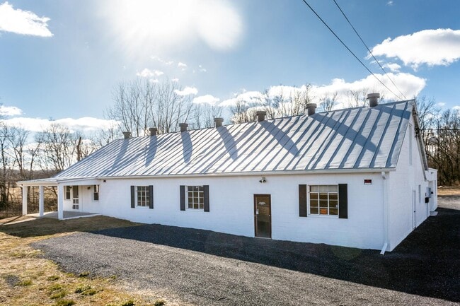
Property Record
292 Brocks Gap Rd, Broadway, VA 22815

Save to a Folder
{{folder.Name}}
{{folder.ListingIds.length}} Properties
{{folder.ListingIds.length}} Property
Create a New Folder
Property Detail
292 Brocks Gap Rd
51-A-L84
BROADWAY
Warehouse
Rockingham
B1
Virginia
AE The base floodplain where base flood elevations are provided. AE Zones are now used on new format FIRMs instead of A1-A30 Zones.
0.63 AC
2026
Staunton & Harrisonburg
2026
Other Market Areas
010700
Harrisonburg, VA
8,833 SF
NEARBY LISTINGS FOR SALE OR LEASE
-
-
View all Broadway listings for sale on LoopNet.com
DEMOGRAPHICS near 292 Brocks Gap Rd
1 mile
3 mile
5 mile
2025 Total Population
2,825
9,509
12,966
2030 Population
2,928
9,801
13,371
Pop Growth 2025-2030
+ 3.65%
+ 3.07%
+ 3.12%
Average Age
41
41
41
2025 Total Households
1,118
3,738
5,073
HH Growth 2025-2030
+ 3.67%
+ 3.10%
+ 3.17%
Median Household Inc
$69,797
$68,827
$69,831
Avg Household Size
2.50
2.50
2.50
2025 Avg HH Vehicles
2.00
2.00
2.00
Median Home Value
$291,131
$267,670
$264,974
Median Year Built
1988
1982
1981
Nearby Places
Map Layers
Map Styles
 Street
 Aerial
Layers
 Traffic
 Biking
Places
Listings with unknown addresses are not visible on the map
- Restaurants
- Banks
- Shops
- Fitness
- Groceries
SALE & LEASE HISTORY
LISTING DATE
SALE/LEASE

Feb 03, 2021
For Sale
Dec 14, 2021
For Lease
Apr 29, 2022
For Sale
Nearby Properties
Address
Land Use
TOTAL SIZE
Lot Size
Zoning
Address
Land Use
TOTAL SIZE
Lot Size
Zoning
225,000 SF
53.75 AC
R1
Address
Land Use
TOTAL SIZE
Lot Size
Zoning
204,203 SF
25 AC
R3
Address
Land Use
TOTAL SIZE
Lot Size
Zoning
61.33 AC
I1
Address
Land Use
TOTAL SIZE
Lot Size
Zoning
71,905 SF
20 AC
R5
Address
Land Use
TOTAL SIZE
Lot Size
Zoning
127,785 SF
14.84 AC
B1
Address
Land Use
TOTAL SIZE
Lot Size
Zoning
1,800 SF
187.24 AC
S1
Address
Land Use
TOTAL SIZE
Lot Size
Zoning
99,168 SF
20 AC
R3
Address
Land Use
TOTAL SIZE
Lot Size
Zoning
98,057 SF
8.67 AC
B1
Address
Land Use
TOTAL SIZE
Lot Size
Zoning
1.97 AC
I1
Address
Land Use
TOTAL SIZE
Lot Size
Zoning
28,412 SF
8.02 AC
R5
Address
Land Use
TOTAL SIZE
Lot Size
Zoning
23,660 SF
14.13 AC
B1
Address
Land Use
TOTAL SIZE
Lot Size
Zoning
7,926 SF
4 AC
R3
Address
Land Use
TOTAL SIZE
Lot Size
Zoning
14,401 SF
7.24 AC
I2
Address
Land Use
TOTAL SIZE
Lot Size
Zoning
26,199 SF
1.24 AC
B1
Address
Land Use
TOTAL SIZE
Lot Size
Zoning
60,170 SF
2.42 AC
B1
Address
Land Use
TOTAL SIZE
Lot Size
Zoning
38,383 SF
1.69 AC
R3
Address
Land Use
TOTAL SIZE
Lot Size
Zoning
2,166 SF
6.31 AC
R5
Address
Land Use
TOTAL SIZE
Lot Size
Zoning
2,957 SF
1.82 AC
M1
Address
Land Use
TOTAL SIZE
Lot Size
Zoning
21,834 SF
6.95 AC
R1
Address
Land Use
TOTAL SIZE
Lot Size
Zoning
4.83 AC
TOWN
Address
Land Use
TOTAL SIZE
Lot Size
Zoning
4 AC
R3
Address
Land Use
TOTAL SIZE
Lot Size
Zoning
7,206 SF
5.88 AC
R5
Address
Land Use
TOTAL SIZE
Lot Size
Zoning
30,693 SF
0.69 AC
R1
Address
Land Use
TOTAL SIZE
Lot Size
Zoning
43,349 SF
4.49 AC
TOWN
Address
Land Use
TOTAL SIZE
Lot Size
Zoning
18,521 SF
8.65 AC
I1
Address
Land Use
TOTAL SIZE
Lot Size
Zoning
38,622 SF
0.81 AC
R2
Address
Land Use
TOTAL SIZE
Lot Size
Zoning
11,501 SF
1.29 AC
B1
Address
Land Use
TOTAL SIZE
Lot Size
Zoning
5,633 SF
7.62 AC
TOWN
Address
Land Use
TOTAL SIZE
Lot Size
Zoning
11,057 SF
1.14 AC
R1
Address
Land Use
TOTAL SIZE
Lot Size
Zoning
90,555 SF
0.67 AC
TOWN
The World's #1 Commercial Real Estate Marketplace
Connect with us
© 2026 CoStar Group
The information above has been obtained from sources believed reliable. While we do not doubt its accuracy we have not verified it and make no guarantee, warranty or representation about it. It is your responsibility to independently confirm its accuracy and completeness. Any projections, opinions, assumptions, or estimates used are for example only and do not represent the current or future performance of the property. The value of this transaction to you depends on tax and other factors which should be evaluated by your tax, financial, and legal advisors. You and your advisors should conduct a careful, independent investigation of the property to determine to your satisfaction the suitability of the property for your needs.