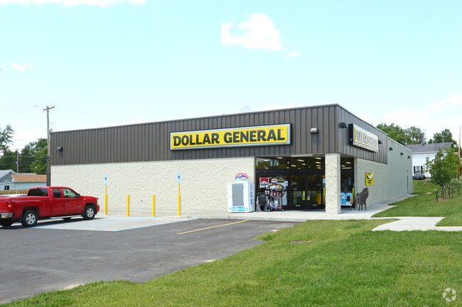
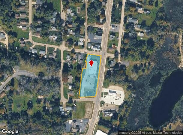
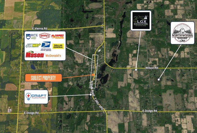
Property Record
292 S State Rd, Otisville, MI 48463
NEARBY LISTINGS FOR SALE OR LEASE
-
-
View all Otisville listings for sale on LoopNet.com
Property Detail
292 S State Rd
Flint, MI
Roger's Addition
09-28-528-044
LOTS 29, 30, 31 & PART OF LOT 32 VILLAGE OF OTISVILLE & PART OF LOT 59 ROGER'S ADDITION TO OTISVILLE DESC AS BEG AT THE
Commercialnec
Genesee
X
Michigan
26157C0650E
29,30,3
2024
1.36 AC
2025
Flint
012402
Detroit
9,156 SF
DEMOGRAPHICS near 292 S State Rd
1 Mile
3 Mile
5 Mile
2024 Total Population
1,005
3,540
9,072
2029 Population
980
3,432
8,849
Pop Growth 2024-2029
(2.49%)
(3.05%)
(2.46%)
Average Age
44
45
44
2024 Total Households
438
1,477
3,643
HH Growth 2024-2029
(2.28%)
(3.11%)
(2.53%)
Median Household Inc
$59,666
$65,287
$65,039
Avg Household Size
2.30
2.40
2.50
2024 Avg HH Vehicles
2.00
2.00
2.00
Median Home Value
$133,625
$172,635
$178,035
Median Year Built
1960
1970
1971
Nearby Places
Map Layers
Map Styles
 Street
 Aerial
- Restaurants
- Banks
- Shops
- Fitness
- Groceries
PUBLIC TRANSPORTATION
AIRPORT
Bishop International
DRIVE
WALK
Distance
Bishop International
44 min
27.5 mi
Freight Ports
Port of Toledo
DRIVE
WALK
Distance
Port of Toledo
159 min
117.3 mi
SALE & LEASE HISTORY
LISTING DATE
SALE/LEASE

Oct 05, 2016
For Sale
Nov 16, 2022
For Sale
Nearby Properties
Address
Land Use
TOTAL SIZE
Lot Size
Zoning
Address
Land Use
TOTAL SIZE
Lot Size
Zoning
68.19 AC
Address
Land Use
TOTAL SIZE
Lot Size
Zoning
38,265 SF
7 AC
Address
Land Use
TOTAL SIZE
Lot Size
Zoning
16,522 SF
20 AC
LI LGT/IND
Address
Land Use
TOTAL SIZE
Lot Size
Zoning
10,177 SF
3.21 AC
Address
Land Use
TOTAL SIZE
Lot Size
Zoning
1,304 SF
145.21 AC
RA-RES/AG
Address
Land Use
TOTAL SIZE
Lot Size
Zoning
1,792 SF
215.16 AC
RA-RES/AG
Address
Land Use
TOTAL SIZE
Lot Size
Zoning
8,320 SF
0.66 AC
Address
Land Use
TOTAL SIZE
Lot Size
Zoning
3,480 SF
40 AC
RA
Address
Land Use
TOTAL SIZE
Lot Size
Zoning
43 AC
MH
Address
Land Use
TOTAL SIZE
Lot Size
Zoning
10,520 SF
9.93 AC
Address
Land Use
TOTAL SIZE
Lot Size
Zoning
174.53 AC
RRA
Address
Land Use
TOTAL SIZE
Lot Size
Zoning
1,404 SF
156.20 AC
RA-RES/AG
Address
Land Use
TOTAL SIZE
Lot Size
Zoning
3,162 SF
80.45 AC
RA-RES/AG
Address
Land Use
TOTAL SIZE
Lot Size
Zoning
2,992 SF
126.56 AC
Address
Land Use
TOTAL SIZE
Lot Size
Zoning
2,352 SF
3.60 AC
Address
Land Use
TOTAL SIZE
Lot Size
Zoning
3,500 SF
1.43 AC
GC GEN/COM
Address
Land Use
TOTAL SIZE
Lot Size
Zoning
12.99 AC
RA-RES/AG
Address
Land Use
TOTAL SIZE
Lot Size
Zoning
1,668 SF
80 AC
Address
Land Use
TOTAL SIZE
Lot Size
Zoning
1,005 SF
151.88 AC
Address
Land Use
TOTAL SIZE
Lot Size
Zoning
1,798 SF
70.03 AC
RRA
Address
Land Use
TOTAL SIZE
Lot Size
Zoning
1,812 SF
79.40 AC
RA-RES/AG
Address
Land Use
TOTAL SIZE
Lot Size
Zoning
5,756 SF
0.50 AC
Address
Land Use
TOTAL SIZE
Lot Size
Zoning
2,857 SF
3.44 AC
Address
Land Use
TOTAL SIZE
Lot Size
Zoning
1,312 SF
80 AC
RA-RES/AG
Address
Land Use
TOTAL SIZE
Lot Size
Zoning
5,328 SF
3.39 AC
CB
Address
Land Use
TOTAL SIZE
Lot Size
Zoning
2,204 SF
29.34 AC
GC GEN/COM
Address
Land Use
TOTAL SIZE
Lot Size
Zoning
Address
Land Use
TOTAL SIZE
Lot Size
Zoning
2,518 SF
80 AC
RA-RES/AG
Address
Land Use
TOTAL SIZE
Lot Size
Zoning
2,170 SF
80 AC
RA-RES/AG
The World's #1 Commercial Real Estate Marketplace
Connect with us
© 2025 CoStar Group
The information above has been obtained from sources believed reliable. While we do not doubt its accuracy we have not verified it and make no guarantee, warranty or representation about it. It is your responsibility to independently confirm its accuracy and completeness. Any projections, opinions, assumptions, or estimates used are for example only and do not represent the current or future performance of the property. The value of this transaction to you depends on tax and other factors which should be evaluated by your tax, financial, and legal advisors. You and your advisors should conduct a careful, independent investigation of the property to determine to your satisfaction the suitability of the property for your needs.