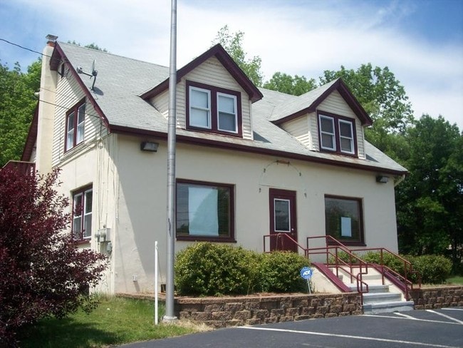
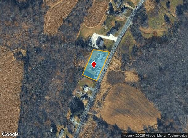
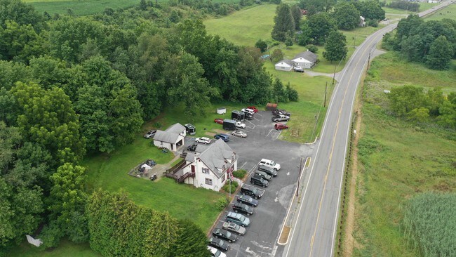
Property Record
292 State Route 565, Wantage, NJ 07461
NEARBY LISTINGS FOR SALE OR LEASE
Property Detail
292 State Route 565
24-00117-0000-00031
Sussex
Retailwithmorethanonenonretailuse
New Jersey
X
31
34037C0170E
0.95 AC
2024
Sussex County
2025
Northern New Jersey
371100
Newark, NJ-PA
1,554 SF
DEMOGRAPHICS near 292 State Route 565
1 Mile
3 Mile
5 Mile
2024 Total Population
171
7,491
21,742
2029 Population
169
7,496
21,891
Pop Growth 2024-2029
(1.17%)
+ 0.07%
+ 0.69%
Average Age
44
43
43
2024 Total Households
64
2,975
8,582
HH Growth 2024-2029
(1.56%)
+ 0.07%
+ 0.76%
Median Household Inc
$57,142
$69,889
$88,025
Avg Household Size
2.70
2.50
2.50
2024 Avg HH Vehicles
2.00
2.00
2.00
Median Home Value
$386,841
$321,020
$306,561
Median Year Built
1984
1971
1978
Nearby Places
Map Layers
Map Styles
 Street
 Aerial
- Restaurants
- Banks
- Shops
- Fitness
- Groceries
PUBLIC TRANSPORTATION
AIRPORT
New York Stewart International
DRIVE
WALK
Distance
New York Stewart International
68 min
47.3 mi
Freight Ports
Maher Terminal
DRIVE
WALK
Distance
Maher Terminal
80 min
55.9 mi
SALE & LEASE HISTORY
LISTING DATE
SALE/LEASE

Aug 07, 2019
For Sale
Nearby Properties
Address
Land Use
TOTAL SIZE
Lot Size
Zoning
Address
Land Use
TOTAL SIZE
Lot Size
Zoning
56 AC
R-5
Address
Land Use
TOTAL SIZE
Lot Size
Zoning
5.73 AC
LI&U
Address
Land Use
TOTAL SIZE
Lot Size
Zoning
7.57 AC
NHCO
Address
Land Use
TOTAL SIZE
Lot Size
Zoning
Address
Land Use
TOTAL SIZE
Lot Size
Zoning
10,920 SF
12.47 AC
R-3
Address
Land Use
TOTAL SIZE
Lot Size
Zoning
1,860 SF
51.68 AC
I-1
Address
Land Use
TOTAL SIZE
Lot Size
Zoning
8,008 SF
6.88 AC
R-3
Address
Land Use
TOTAL SIZE
Lot Size
Zoning
61,795 SF
7.79 AC
P
Address
Land Use
TOTAL SIZE
Lot Size
Zoning
0.36 AC
R-1
Address
Land Use
TOTAL SIZE
Lot Size
Zoning
5.88 AC
HWCO
Address
Land Use
TOTAL SIZE
Lot Size
Zoning
19,388 SF
6.05 AC
HWCO
Address
Land Use
TOTAL SIZE
Lot Size
Zoning
35,191 SF
12.72 AC
R-1
Address
Land Use
TOTAL SIZE
Lot Size
Zoning
16,989 SF
11.66 AC
R-5
Address
Land Use
TOTAL SIZE
Lot Size
Zoning
5,424 SF
2.74 AC
Address
Land Use
TOTAL SIZE
Lot Size
Zoning
15,180 SF
9.04 AC
HWCO
Address
Land Use
TOTAL SIZE
Lot Size
Zoning
21,250 SF
2.66 AC
C-2
Address
Land Use
TOTAL SIZE
Lot Size
Zoning
18,548 SF
21.73 AC
LTI
Address
Land Use
TOTAL SIZE
Lot Size
Zoning
Address
Land Use
TOTAL SIZE
Lot Size
Zoning
63,528 SF
1.36 AC
INST
Address
Land Use
TOTAL SIZE
Lot Size
Zoning
8,756 SF
1 AC
MID2
Address
Land Use
TOTAL SIZE
Lot Size
Zoning
720 SF
10.70 AC
MID2
Address
Land Use
TOTAL SIZE
Lot Size
Zoning
10,000 SF
2.57 AC
HWCO
Address
Land Use
TOTAL SIZE
Lot Size
Zoning
19,920 SF
0.14 AC
C-1
Address
Land Use
TOTAL SIZE
Lot Size
Zoning
6,064 SF
1 AC
R-5
Address
Land Use
TOTAL SIZE
Lot Size
Zoning
1,243 SF
3.85 AC
R-5
Address
Land Use
TOTAL SIZE
Lot Size
Zoning
41.50 AC
R01
Address
Land Use
TOTAL SIZE
Lot Size
Zoning
10,836 SF
1.55 AC
Address
Land Use
TOTAL SIZE
Lot Size
Zoning
95.76 AC
LTI
Address
Land Use
TOTAL SIZE
Lot Size
Zoning
5,489 SF
1 AC
MID2
Address
Land Use
TOTAL SIZE
Lot Size
Zoning
20,100 SF
5.90 AC
HWCO
The World's #1 Commercial Real Estate Marketplace
Connect with us
© 2025 CoStar Group
The information above has been obtained from sources believed reliable. While we do not doubt its accuracy we have not verified it and make no guarantee, warranty or representation about it. It is your responsibility to independently confirm its accuracy and completeness. Any projections, opinions, assumptions, or estimates used are for example only and do not represent the current or future performance of the property. The value of this transaction to you depends on tax and other factors which should be evaluated by your tax, financial, and legal advisors. You and your advisors should conduct a careful, independent investigation of the property to determine to your satisfaction the suitability of the property for your needs.