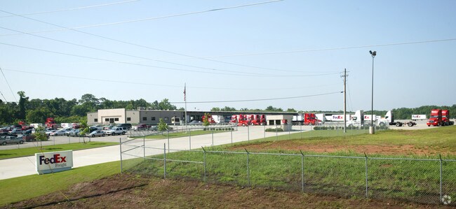
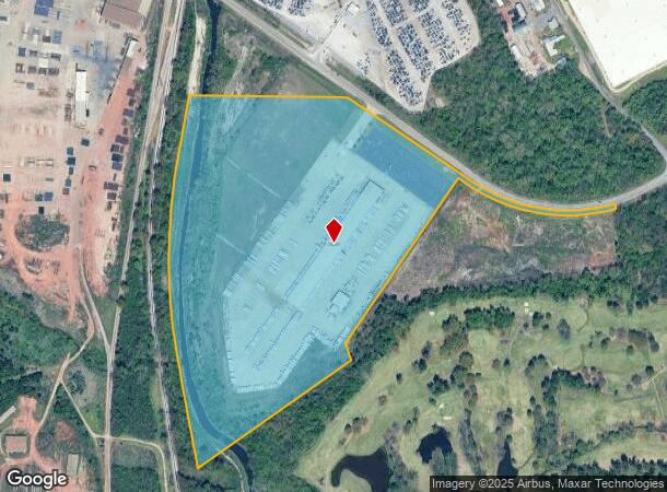
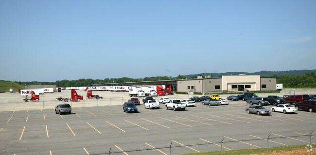
Property Record
2920 Davey Allison Blvd, Bessemer, AL 35020
NEARBY LISTINGS FOR SALE OR LEASE
Property Detail
2920 Davey Allison Blvd
Birmingham, AL
M D G Subdivision
30-00-33-2-001-001.000
PT LOT 1-A MDG SUBDIVISION PB 37 PG 74 LYING IN NW 1/4 SEC 33 TP 18 R 4W DESC AS FOLS COM NW COR OF SD 1/4 TH E 110 FT TO POB TH SLY ALG E/L OF RR RW 2260 FTTH NE 1330(D) 1120(S) TH NW 108.1 FT TH NW 1213.7 FT TH NW 835 FT TH W 965 FT TO POB
Warehouse
Jefferson
AE
Alabama
01073C0537H
1-a
2023
44 AC
2024
Bessemer
013801
Birmingham
77,902 SF
DEMOGRAPHICS near 2920 Davey Allison Blvd
1 Mile
3 Mile
5 Mile
2024 Total Population
1,680
39,673
77,774
2029 Population
1,658
39,269
76,928
Pop Growth 2024-2029
(1.31%)
(1.02%)
(1.09%)
Average Age
40
40
40
2024 Total Households
655
15,719
30,949
HH Growth 2024-2029
(1.37%)
(1.12%)
(1.21%)
Median Household Inc
$61,647
$43,192
$45,569
Avg Household Size
2.50
2.40
2.40
2024 Avg HH Vehicles
2.00
2.00
2.00
Median Home Value
$119,628
$118,574
$124,695
Median Year Built
1959
1964
1966
Nearby Places
Map Layers
Map Styles
 Street
 Aerial
- Restaurants
- Banks
- Shops
- Fitness
- Groceries
PUBLIC TRANSPORTATION
AIRPORT
Birmingham-Shuttlesworth International
DRIVE
WALK
Distance
Birmingham-Shuttlesworth International
30 min
18.3 mi
Nearby Properties
Address
Land Use
TOTAL SIZE
Lot Size
Zoning
Address
Land Use
TOTAL SIZE
Lot Size
Zoning
460,483 SF
20 AC
I3
Address
Land Use
TOTAL SIZE
Lot Size
Zoning
195,495 SF
28.97 AC
B3
Address
Land Use
TOTAL SIZE
Lot Size
Zoning
553,137 SF
87 AC
I2
Address
Land Use
TOTAL SIZE
Lot Size
Zoning
191,664 SF
14.73 AC
R4
Address
Land Use
TOTAL SIZE
Lot Size
Zoning
136,115 SF
14.90 AC
C3
Address
Land Use
TOTAL SIZE
Lot Size
Zoning
145,300 SF
25 AC
R3
Address
Land Use
TOTAL SIZE
Lot Size
Zoning
219,210 SF
19.40 AC
M2
Address
Land Use
TOTAL SIZE
Lot Size
Zoning
230,088 SF
I3
Address
Land Use
TOTAL SIZE
Lot Size
Zoning
66,928 SF
5.70 AC
B2-R
Address
Land Use
TOTAL SIZE
Lot Size
Zoning
1,090,237 SF
28.10 AC
I4
Address
Land Use
TOTAL SIZE
Lot Size
Zoning
66,900 SF
3.78 AC
I4
Address
Land Use
TOTAL SIZE
Lot Size
Zoning
58,822 SF
7.80 AC
B3
Address
Land Use
TOTAL SIZE
Lot Size
Zoning
1,200 SF
13.40 AC
R3
Address
Land Use
TOTAL SIZE
Lot Size
Zoning
69,344 SF
2.30 AC
B-1
Address
Land Use
TOTAL SIZE
Lot Size
Zoning
26,234 SF
3.30 AC
B2
Address
Land Use
TOTAL SIZE
Lot Size
Zoning
366,421 SF
21 AC
I3
Address
Land Use
TOTAL SIZE
Lot Size
Zoning
80,043 SF
10.89 AC
B3-C
Address
Land Use
TOTAL SIZE
Lot Size
Zoning
163,056 SF
I-3
Address
Land Use
TOTAL SIZE
Lot Size
Zoning
49,022 SF
5.50 AC
R2
Address
Land Use
TOTAL SIZE
Lot Size
Zoning
43,674 SF
0.44 AC
C3
Address
Land Use
TOTAL SIZE
Lot Size
Zoning
80,220 SF
6.68 AC
M2
Address
Land Use
TOTAL SIZE
Lot Size
Zoning
172,253 SF
20 AC
C1
Address
Land Use
TOTAL SIZE
Lot Size
Zoning
40,098 SF
0.48 AC
C1
Address
Land Use
TOTAL SIZE
Lot Size
Zoning
52,810 SF
3.44 AC
B-3
Address
Land Use
TOTAL SIZE
Lot Size
Zoning
65,232 SF
3.60 AC
R-5
Address
Land Use
TOTAL SIZE
Lot Size
Zoning
59,554 SF
1.37 AC
R2
Address
Land Use
TOTAL SIZE
Lot Size
Zoning
32,606 SF
2.18 AC
B2-R
Address
Land Use
TOTAL SIZE
Lot Size
Zoning
51,920 SF
1.70 AC
01
Address
Land Use
TOTAL SIZE
Lot Size
Zoning
81,831 SF
4.69 AC
R2
The World's #1 Commercial Real Estate Marketplace
Connect with us
© 2026 CoStar Group
The information above has been obtained from sources believed reliable. While we do not doubt its accuracy we have not verified it and make no guarantee, warranty or representation about it. It is your responsibility to independently confirm its accuracy and completeness. Any projections, opinions, assumptions, or estimates used are for example only and do not represent the current or future performance of the property. The value of this transaction to you depends on tax and other factors which should be evaluated by your tax, financial, and legal advisors. You and your advisors should conduct a careful, independent investigation of the property to determine to your satisfaction the suitability of the property for your needs.