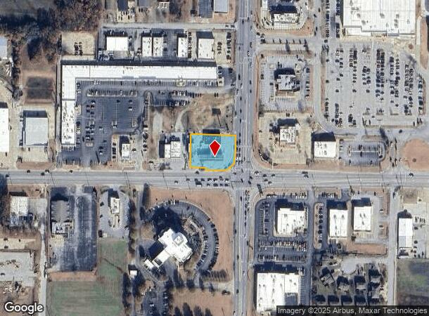
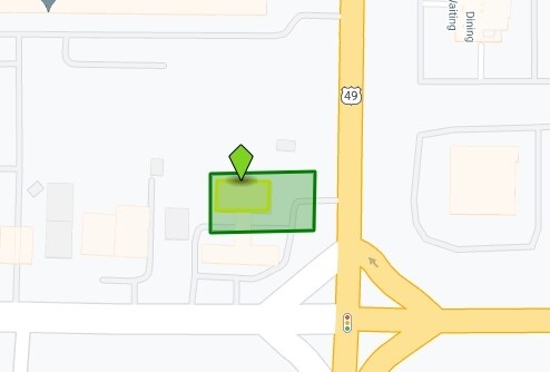
Property Record
2920 E Highland Dr, Jonesboro, AR 72401
NEARBY LISTINGS FOR SALE OR LEASE
Property Detail
2920 E Highland Dr
Jonesboro, AR
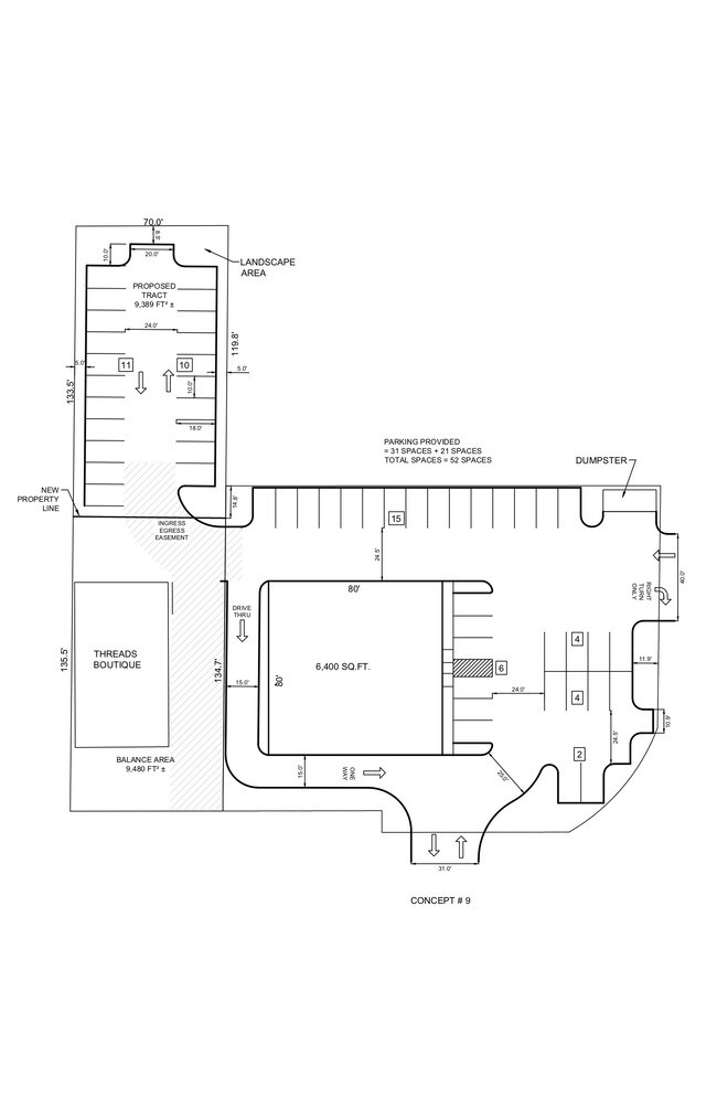
Flash Market Minor Plat
01-144213-04100
FLASH MARKET MINOR PLAT PT SE SW
Storebuilding
Craighead
X
Arkansas
05031C0258D
1
2024
0.67 AC
2025
Arkansas North Area
000102
Other Market Areas
3,958 SF
DEMOGRAPHICS near 2920 E Highland Dr
1 Mile
3 Mile
5 Mile
2024 Total Population
5,580
49,643
77,521
2029 Population
5,956
53,057
82,750
Pop Growth 2024-2029
+ 6.74%
+ 6.88%
+ 6.75%
Average Age
36
36
37
2024 Total Households
2,290
20,487
30,663
HH Growth 2024-2029
+ 6.64%
+ 7.01%
+ 6.80%
Median Household Inc
$25,654
$39,391
$45,481
Avg Household Size
2.30
2.20
2.40
2024 Avg HH Vehicles
2.00
2.00
2.00
Median Home Value
$158,115
$171,029
$183,434
Median Year Built
1985
1991
1992
Nearby Places
Map Layers
Map Styles
 Street
 Aerial
- Restaurants
- Banks
- Shops
- Fitness
- Groceries
SALE & LEASE HISTORY
LISTING DATE
SALE/LEASE

Dec 12, 2019
For Sale
Apr 22, 2021
For Sale
Nearby Properties
Address
Land Use
TOTAL SIZE
Lot Size
Zoning
Address
Land Use
TOTAL SIZE
Lot Size
Zoning
38,357 SF
5.41 AC
Address
Land Use
TOTAL SIZE
Lot Size
Zoning
353,512 SF
15.01 AC
Address
Land Use
TOTAL SIZE
Lot Size
Zoning
45,783 SF
346.92 AC
Address
Land Use
TOTAL SIZE
Lot Size
Zoning
61,868 SF
15.69 AC
Address
Land Use
TOTAL SIZE
Lot Size
Zoning
56,279 SF
8.37 AC
Address
Land Use
TOTAL SIZE
Lot Size
Zoning
219,080 SF
10.93 AC
Address
Land Use
TOTAL SIZE
Lot Size
Zoning
141,878 SF
8.30 AC
Address
Land Use
TOTAL SIZE
Lot Size
Zoning
19,078 SF
55.47 AC
Address
Land Use
TOTAL SIZE
Lot Size
Zoning
18,470 SF
1.54 AC
Address
Land Use
TOTAL SIZE
Lot Size
Zoning
99,212 SF
7.49 AC
Address
Land Use
TOTAL SIZE
Lot Size
Zoning
120,208 SF
10.21 AC
Address
Land Use
TOTAL SIZE
Lot Size
Zoning
152,814 SF
13.62 AC
Address
Land Use
TOTAL SIZE
Lot Size
Zoning
6.89 AC
Address
Land Use
TOTAL SIZE
Lot Size
Zoning
60,180 SF
10.23 AC
Address
Land Use
TOTAL SIZE
Lot Size
Zoning
403,826 SF
73.09 AC
Address
Land Use
TOTAL SIZE
Lot Size
Zoning
Address
Land Use
TOTAL SIZE
Lot Size
Zoning
24,719 SF
24.88 AC
Address
Land Use
TOTAL SIZE
Lot Size
Zoning
39,399 SF
11.23 AC
Address
Land Use
TOTAL SIZE
Lot Size
Zoning
65,020 SF
0.30 AC
Address
Land Use
TOTAL SIZE
Lot Size
Zoning
29,766 SF
2.41 AC
Address
Land Use
TOTAL SIZE
Lot Size
Zoning
313,488 SF
34.95 AC
Address
Land Use
TOTAL SIZE
Lot Size
Zoning
86,075 SF
4.82 AC
Address
Land Use
TOTAL SIZE
Lot Size
Zoning
79,649 SF
2.71 AC
Address
Land Use
TOTAL SIZE
Lot Size
Zoning
62,735 SF
5.05 AC
Address
Land Use
TOTAL SIZE
Lot Size
Zoning
17,155 SF
16.91 AC
Address
Land Use
TOTAL SIZE
Lot Size
Zoning
104,717 SF
8.70 AC
Address
Land Use
TOTAL SIZE
Lot Size
Zoning
144,936 SF
10.40 AC
Address
Land Use
TOTAL SIZE
Lot Size
Zoning
68,081 SF
1.90 AC
The World's #1 Commercial Real Estate Marketplace
Connect with us
© 2025 CoStar Group
The information above has been obtained from sources believed reliable. While we do not doubt its accuracy we have not verified it and make no guarantee, warranty or representation about it. It is your responsibility to independently confirm its accuracy and completeness. Any projections, opinions, assumptions, or estimates used are for example only and do not represent the current or future performance of the property. The value of this transaction to you depends on tax and other factors which should be evaluated by your tax, financial, and legal advisors. You and your advisors should conduct a careful, independent investigation of the property to determine to your satisfaction the suitability of the property for your needs.