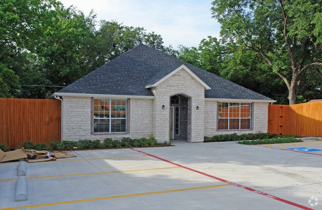
Property Record
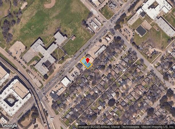
2920 Inwood Rd, Dallas, TX 75235
Current Lease Availabilities
NEARBY LISTINGS FOR SALE OR LEASE
Property Detail
2920 Inwood Rd
Dallas-Fort Worth-Arlington, TX
Cherrywood
00000332158000000
CHERRYWOOD BLK 1/4624 LT 8 INT202200323089 DD12162022 CO-DC 4624 001 00800 1004624 001
Officebuilding
Dallas
X
Texas
48113C0330J
8
2024
0.18 AC
2025
Preston Center
000407
Dallas/Ft Worth
2,064 SF
DEMOGRAPHICS near 2920 Inwood Rd
1 Mile
3 Mile
5 Mile
2024 Total Population
22,401
140,806
364,714
2029 Population
22,828
142,036
367,973
Pop Growth 2024-2029
+ 1.91%
+ 0.87%
+ 0.89%
Average Age
37
37
37
2024 Total Households
12,198
75,456
175,704
HH Growth 2024-2029
+ 1.63%
+ 0.87%
+ 1.04%
Median Household Inc
$57,882
$86,478
$76,051
Avg Household Size
1.70
1.80
2.00
2024 Avg HH Vehicles
1.00
1.00
2.00
Median Home Value
$358,676
$575,750
$525,272
Median Year Built
2002
2000
1992
Nearby Places
- Restaurants
- Banks
- Shops
- Fitness
- Groceries
PUBLIC TRANSPORTATION
TRANSIT/SUBWAY
Inwood/Love Field Station (DART LIGHT RAIL - GREEN LINE - Dallas Area Rapid Transit (DART), DART LIGHT RAIL - ORANGE LINE - Dallas Area Rapid Transit (DART), Green Line - Dallas Area Rapid Transit (DART), Orange Line - Dallas Area Rapid Transit (DART))
DRIVE
WALK
Distance
Inwood/Love Field Station (DART LIGHT RAIL - GREEN LINE - Dallas Area Rapid Transit (DART), DART LIGHT RAIL - ORANGE LINE - Dallas Area Rapid Transit (DART), Green Line - Dallas Area Rapid Transit (DART), Orange Line - Dallas Area Rapid Transit (DART))
2 min
4 min
0.2 mi
Southwestern Medical District/Parkland Station (DART LIGHT RAIL - GREEN LINE - Dallas Area Rapid Transit (DART), DART LIGHT RAIL - ORANGE LINE - Dallas Area Rapid Transit (DART), Green Line - Dallas Area Rapid Transit (DART), Orange Line - Dallas Area Rapid Transit (DART))
DRIVE
WALK
Distance
Southwestern Medical District/Parkland Station (DART LIGHT RAIL - GREEN LINE - Dallas Area Rapid Transit (DART), DART LIGHT RAIL - ORANGE LINE - Dallas Area Rapid Transit (DART), Green Line - Dallas Area Rapid Transit (DART), Orange Line - Dallas Area Rapid Transit (DART))
3 min
16 min
0.8 mi
COMMUTER RAIL
Medical/Market Ctr Station (TRINITY RAILWAY - Dallas Area Rapid Transit (DART))
DRIVE
WALK
Distance
Medical/Market Ctr Station (TRINITY RAILWAY - Dallas Area Rapid Transit (DART))
4 min
1.9 mi
Medical/Market Center (Trinity Railway Express - Dallas Area Rapid Transit (DART))
DRIVE
WALK
Distance
Medical/Market Center (Trinity Railway Express - Dallas Area Rapid Transit (DART))
4 min
1.9 mi
AIRPORT
Dallas Love Field
DRIVE
WALK
Distance
Dallas Love Field
4 min
1.9 mi
Dallas-Fort Worth International
DRIVE
WALK
Distance
Dallas-Fort Worth International
24 min
18.0 mi
Freight Ports
Port of Shreveport
DRIVE
WALK
Distance
Port of Shreveport
219 min
199.3 mi
Nearby Properties
Address
Land Use
TOTAL SIZE
Lot Size
Zoning
Address
Land Use
TOTAL SIZE
Lot Size
Zoning
2,658,374 SF
37.70 AC
Z116
Address
Land Use
TOTAL SIZE
Lot Size
Zoning
1,634,356 SF
92.90 AC
Z421
Address
Land Use
TOTAL SIZE
Lot Size
Zoning
2,476 SF
1,203.03 AC
Z116
Address
Land Use
TOTAL SIZE
Lot Size
Zoning
2,271,924 SF
Address
Land Use
TOTAL SIZE
Lot Size
Zoning
3,713,071 SF
9.94 AC
Address
Land Use
TOTAL SIZE
Lot Size
Zoning
4,407,366 SF
1,300 AC
IR
Address
Land Use
TOTAL SIZE
Lot Size
Zoning
815,000 SF
7.20 AC
Z239
Address
Land Use
TOTAL SIZE
Lot Size
Zoning
906,730 SF
3.09 AC
Z239
Address
Land Use
TOTAL SIZE
Lot Size
Zoning
1,003,498 SF
22.15 AC
Z116
Address
Land Use
TOTAL SIZE
Lot Size
Zoning
299,170 SF
9.71 AC
Z97
Address
Land Use
TOTAL SIZE
Lot Size
Zoning
731,849 SF
3.13 AC
Z239
Address
Land Use
TOTAL SIZE
Lot Size
Zoning
1,896,570 SF
18.08 AC
Z151
Address
Land Use
TOTAL SIZE
Lot Size
Zoning
1,291,660 SF
2.56 AC
Z248
Address
Land Use
TOTAL SIZE
Lot Size
Zoning
1,026,046 SF
2.89 AC
Z248
Address
Land Use
TOTAL SIZE
Lot Size
Zoning
864,909 SF
3.02 AC
Z248
Address
Land Use
TOTAL SIZE
Lot Size
Zoning
504,533 SF
9.95 AC
Z151
Address
Land Use
TOTAL SIZE
Lot Size
Zoning
1,001,504 SF
3.37 AC
Z151
Address
Land Use
TOTAL SIZE
Lot Size
Zoning
1,228,418 SF
24.51 AC
Z151
Address
Land Use
TOTAL SIZE
Lot Size
Zoning
724,979 SF
1.05 AC
Z239
Address
Land Use
TOTAL SIZE
Lot Size
Zoning
857,292 SF
1.47 AC
Z239
Address
Land Use
TOTAL SIZE
Lot Size
Zoning
602,716 SF
11.21 AC
Z239
Address
Land Use
TOTAL SIZE
Lot Size
Zoning
763,198 SF
3.01 AC
Z248
Address
Land Use
TOTAL SIZE
Lot Size
Zoning
638,046 SF
2.11 AC
Z239
Address
Land Use
TOTAL SIZE
Lot Size
Zoning
906,627 SF
3.83 AC
Z239
Address
Land Use
TOTAL SIZE
Lot Size
Zoning
812,701 SF
3.73 AC
Address
Land Use
TOTAL SIZE
Lot Size
Zoning
653,557 SF
0.68 AC
Z248
Address
Land Use
TOTAL SIZE
Lot Size
Zoning
676,930 SF
1.38 AC
Z248
Address
Land Use
TOTAL SIZE
Lot Size
Zoning
525,016 SF
6.51 AC
Z151
Address
Land Use
TOTAL SIZE
Lot Size
Zoning
512,667 SF
16.10 AC
Z151
Address
Land Use
TOTAL SIZE
Lot Size
Zoning
784,725 SF
2.33 AC
Z239
The World's #1 Commercial Real Estate Marketplace
Connect with us
© 2025 CoStar Group
The information above has been obtained from sources believed reliable. While we do not doubt its accuracy we have not verified it and make no guarantee, warranty or representation about it. It is your responsibility to independently confirm its accuracy and completeness. Any projections, opinions, assumptions, or estimates used are for example only and do not represent the current or future performance of the property. The value of this transaction to you depends on tax and other factors which should be evaluated by your tax, financial, and legal advisors. You and your advisors should conduct a careful, independent investigation of the property to determine to your satisfaction the suitability of the property for your needs.