Property Record
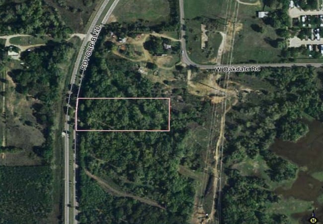
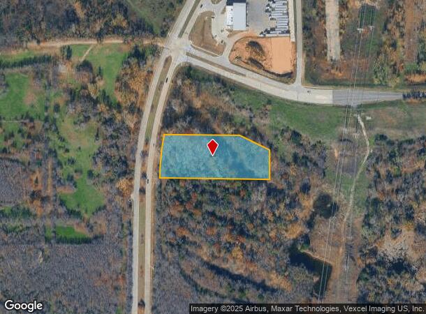
2920 Roy Orr Blvd, Grand Prairie, TX 75050

NEARBY LISTINGS FOR SALE OR LEASE
Property Detail
2920 Roy Orr Blvd
Dallas-Fort Worth-Arlington, TX
H P Crocker
65170347010020200
H P CROCKER ABST 1703 PG 470 TR 2.2 ACS 2.35 108900 SQ VOL91150/1671 EX072991 CO-DALLAS 1703470100202 5CP17034701
Agriculturalland
Dallas
AE
Texas
48439C0245L
2.35 AC
2024
Grand Prairie
2025
Dallas/Ft Worth
015304
DEMOGRAPHICS near 2920 Roy Orr Blvd
1 Mile
3 Mile
5 Mile
2024 Total Population
2,779
67,588
250,436
2029 Population
2,746
68,938
255,289
Pop Growth 2024-2029
(1.19%)
+ 2.00%
+ 1.94%
Average Age
37
35
35
2024 Total Households
927
28,314
94,977
HH Growth 2024-2029
(1.40%)
+ 2.24%
+ 2.29%
Median Household Inc
$67,405
$58,526
$55,906
Avg Household Size
3.00
2.30
2.60
2024 Avg HH Vehicles
2.00
2.00
2.00
Median Home Value
$197,221
$249,055
$229,472
Median Year Built
1983
1987
1982
Nearby Places
Map Layers
Map Styles
 Street
 Aerial
- Restaurants
- Banks
- Shops
- Fitness
- Groceries
PUBLIC TRANSPORTATION
COMMUTER RAIL
DRIVE
WALK
Distance
7 min
2.4 mi
DRIVE
WALK
Distance
5 min
2.6 mi
AIRPORT
Dallas-Fort Worth International
DRIVE
WALK
Distance
Dallas-Fort Worth International
16 min
8.7 mi
Dallas Love Field
DRIVE
WALK
Distance
Dallas Love Field
26 min
16.1 mi
SALE & LEASE HISTORY
LISTING DATE
SALE/LEASE

Sep 24, 2016
For Sale
Mar 28, 2018
For Sale
Nearby Properties
Address
Land Use
TOTAL SIZE
Lot Size
Zoning
Address
Land Use
TOTAL SIZE
Lot Size
Zoning
467,694 SF
24.03 AC
Address
Land Use
TOTAL SIZE
Lot Size
Zoning
516,974 SF
23.81 AC
Address
Land Use
TOTAL SIZE
Lot Size
Zoning
485,911 SF
54.76 AC
Address
Land Use
TOTAL SIZE
Lot Size
Zoning
522,294 SF
18.35 AC
Address
Land Use
TOTAL SIZE
Lot Size
Zoning
703,500 SF
47.38 AC
Z236
Address
Land Use
TOTAL SIZE
Lot Size
Zoning
501,933 SF
16.25 AC
Address
Land Use
TOTAL SIZE
Lot Size
Zoning
496,283 SF
246.29 AC
Z236
Address
Land Use
TOTAL SIZE
Lot Size
Zoning
422,880 SF
20.06 AC
Z177
Address
Land Use
TOTAL SIZE
Lot Size
Zoning
294,296 SF
12.08 AC
Address
Land Use
TOTAL SIZE
Lot Size
Zoning
738,276 SF
40.57 AC
Z243
Address
Land Use
TOTAL SIZE
Lot Size
Zoning
450,535 SF
27.23 AC
Address
Land Use
TOTAL SIZE
Lot Size
Zoning
680,900 SF
32.25 AC
Z236
Address
Land Use
TOTAL SIZE
Lot Size
Zoning
683,300 SF
40.23 AC
Z01
Address
Land Use
TOTAL SIZE
Lot Size
Zoning
266,586 SF
11.47 AC
Address
Land Use
TOTAL SIZE
Lot Size
Zoning
342,583 SF
23.87 AC
Address
Land Use
TOTAL SIZE
Lot Size
Zoning
334,057 SF
20.05 AC
Z312
Address
Land Use
TOTAL SIZE
Lot Size
Zoning
339,965 SF
15.59 AC
Address
Land Use
TOTAL SIZE
Lot Size
Zoning
358,350 SF
13.15 AC
Address
Land Use
TOTAL SIZE
Lot Size
Zoning
576,000 SF
55.36 AC
Z123
Address
Land Use
TOTAL SIZE
Lot Size
Zoning
413,524 SF
24.70 AC
Z198
Address
Land Use
TOTAL SIZE
Lot Size
Zoning
285,194 SF
15.91 AC
Address
Land Use
TOTAL SIZE
Lot Size
Zoning
531,072 SF
26.50 AC
Z236
Address
Land Use
TOTAL SIZE
Lot Size
Zoning
585,000 SF
27.06 AC
Z123
Address
Land Use
TOTAL SIZE
Lot Size
Zoning
520,000 SF
28.92 AC
Z123
Address
Land Use
TOTAL SIZE
Lot Size
Zoning
563,300 SF
27.40 AC
Z128
Address
Land Use
TOTAL SIZE
Lot Size
Zoning
253,710 SF
11.50 AC
Address
Land Use
TOTAL SIZE
Lot Size
Zoning
500,256 SF
25.64 AC
Z123
Address
Land Use
TOTAL SIZE
Lot Size
Zoning
267,684 SF
11.01 AC
Address
Land Use
TOTAL SIZE
Lot Size
Zoning
266,448 SF
17 AC
Z97
Address
Land Use
TOTAL SIZE
Lot Size
Zoning
209,751 SF
6.65 AC
The World's #1 Commercial Real Estate Marketplace
Connect with us
© 2025 CoStar Group
The information above has been obtained from sources believed reliable. While we do not doubt its accuracy we have not verified it and make no guarantee, warranty or representation about it. It is your responsibility to independently confirm its accuracy and completeness. Any projections, opinions, assumptions, or estimates used are for example only and do not represent the current or future performance of the property. The value of this transaction to you depends on tax and other factors which should be evaluated by your tax, financial, and legal advisors. You and your advisors should conduct a careful, independent investigation of the property to determine to your satisfaction the suitability of the property for your needs.