Property Record
2920 S Mall Rd Ne, Knoxville, TN 37917
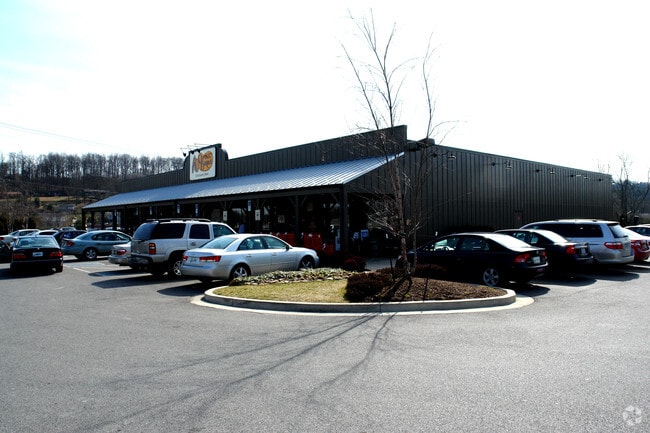


Property Detail
2920 S Mall Rd Ne
Knoxville, TN
SUBDIVISIONNAME ISAIAHS LANDING MAPPLATB 20020529 MAPPL ATP 0098061 DIMENSIONS 364.67 X 294.99 X IRR
059LG-001
KNOX
Restaurantbuilding
Tennessee
B and X Area of moderate flood hazard, usually the area between the limits of the 100-year and 500-year floods.
1
2025
1.82 AC
2025
North/Broadway
003100
Knoxville
10,062 SF
NEARBY LISTINGS FOR SALE OR LEASE
DEMOGRAPHICS near 2920 S Mall Rd Ne
1 mile
3 mile
5 mile
2025 Total Population
4,411
41,253
108,160
2030 Population
4,615
43,136
113,440
Pop Growth 2025-2030
+ 4.62%
+ 4.56%
+ 4.88%
Average Age
41
41
40
2025 Total Households
1,997
17,577
47,208
HH Growth 2025-2030
+ 4.61%
+ 4.51%
+ 4.91%
Median Household Inc
$59,560
$62,384
$54,219
Avg Household Size
2.10
2.30
2.20
2025 Avg HH Vehicles
2.00
2.00
2.00
Median Home Value
$264,652
$281,806
$271,335
Median Year Built
1989
1973
1973
Nearby Places
Map Layers
Map Styles
 Street
 Aerial
Layers
 Traffic
 Biking
Places
Listings with unknown addresses are not visible on the map
- Restaurants
- Banks
- Shops
- Fitness
- Groceries
PUBLIC TRANSPORTATION
AIRPORT
McGhee Tyson
Drive
Walk
Distance
McGhee Tyson
40 min
24.1 mi
Nearby Properties
Address
Land Use
TOTAL SIZE
Lot Size
Zoning
Address
Land Use
TOTAL SIZE
Lot Size
Zoning
224,536 SF
81.84 AC
Address
Land Use
TOTAL SIZE
Lot Size
Zoning
3,196 SF
28.14 AC
Address
Land Use
TOTAL SIZE
Lot Size
Zoning
1,134 SF
6.97 AC
Address
Land Use
TOTAL SIZE
Lot Size
Zoning
2,700 SF
22.24 AC
Address
Land Use
TOTAL SIZE
Lot Size
Zoning
1,822 SF
6.85 AC
Address
Land Use
TOTAL SIZE
Lot Size
Zoning
3,550 SF
8 AC
Address
Land Use
TOTAL SIZE
Lot Size
Zoning
27,420 SF
1.16 AC
Address
Land Use
TOTAL SIZE
Lot Size
Zoning
105,408 SF
9.33 AC
Address
Land Use
TOTAL SIZE
Lot Size
Zoning
89,492 SF
5.88 AC
Address
Land Use
TOTAL SIZE
Lot Size
Zoning
227,592 SF
22.25 AC
Address
Land Use
TOTAL SIZE
Lot Size
Zoning
2,922 SF
10.94 AC
Address
Land Use
TOTAL SIZE
Lot Size
Zoning
23,927 SF
1.91 AC
Address
Land Use
TOTAL SIZE
Lot Size
Zoning
160,000 SF
39.50 AC
Address
Land Use
TOTAL SIZE
Lot Size
Zoning
26,484 SF
6.77 AC
Address
Land Use
TOTAL SIZE
Lot Size
Zoning
6,120 SF
16.39 AC
Address
Land Use
TOTAL SIZE
Lot Size
Zoning
106,946 SF
12.57 AC
Address
Land Use
TOTAL SIZE
Lot Size
Zoning
59,410 SF
6 AC
Address
Land Use
TOTAL SIZE
Lot Size
Zoning
142,092 SF
13.90 AC
Address
Land Use
TOTAL SIZE
Lot Size
Zoning
128,639 SF
12.39 AC
Address
Land Use
TOTAL SIZE
Lot Size
Zoning
100 SF
423.35 AC
Address
Land Use
TOTAL SIZE
Lot Size
Zoning
87,256 SF
21.45 AC
Address
Land Use
TOTAL SIZE
Lot Size
Zoning
30,956 SF
8.31 AC
Address
Land Use
TOTAL SIZE
Lot Size
Zoning
4,740 SF
90.57 AC
Address
Land Use
TOTAL SIZE
Lot Size
Zoning
275,775 SF
11.50 AC
Address
Land Use
TOTAL SIZE
Lot Size
Zoning
107,290 SF
8.03 AC
Address
Land Use
TOTAL SIZE
Lot Size
Zoning
114,636 SF
10.89 AC
Address
Land Use
TOTAL SIZE
Lot Size
Zoning
63,149 SF
6.30 AC
Address
Land Use
TOTAL SIZE
Lot Size
Zoning
92,592 SF
1.89 AC
Address
Land Use
TOTAL SIZE
Lot Size
Zoning
61,575 SF
6.43 AC
Address
Land Use
TOTAL SIZE
Lot Size
Zoning
93,427 SF
15.54 AC
The World's #1 Commercial Real Estate Marketplace
Connect with us
© 2026 CoStar Group
The information above has been obtained from sources believed reliable. While we do not doubt its accuracy we have not verified it and make no guarantee, warranty or representation about it. It is your responsibility to independently confirm its accuracy and completeness. Any projections, opinions, assumptions, or estimates used are for example only and do not represent the current or future performance of the property. The value of this transaction to you depends on tax and other factors which should be evaluated by your tax, financial, and legal advisors. You and your advisors should conduct a careful, independent investigation of the property to determine to your satisfaction the suitability of the property for your needs.