Property Record
2920 Shotts St, Fort Worth, TX 76107


Save to a Folder
{{folder.Name}}
{{folder.ListingIds.length}} Properties
{{folder.ListingIds.length}} Property
Create a New Folder
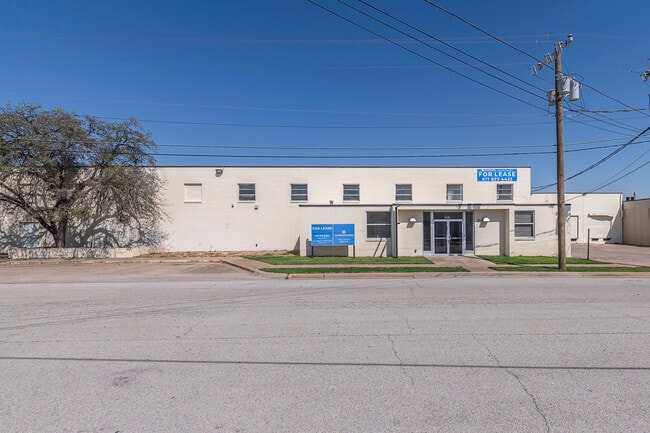
Property Detail
2920 Shotts St
Dallas-Fort Worth-Arlington, TX
BAILEYS INDUSTRIAL ADDITION BLOCK B LOT 2B
00111619
TARRANT
Commercialnec
Texas
B and X Area of moderate flood hazard, usually the area between the limits of the 100-year and 500-year floods.
2b
2025
0.57 AC
2025
N Central Ft Worth
102000
Dallas/Ft Worth
23,801 SF
NEARBY LISTINGS FOR SALE OR LEASE
DEMOGRAPHICS near 2920 Shotts St
1 mile
3 mile
5 mile
2025 Total Population
12,589
105,215
269,495
2030 Population
13,467
112,266
287,304
Pop Growth 2025-2030
+ 6.97%
+ 6.70%
+ 6.61%
Average Age
38
38
37
2025 Total Households
7,159
42,107
98,147
HH Growth 2025-2030
+ 7.53%
+ 7.24%
+ 6.97%
Median Household Inc
$75,480
$71,882
$63,922
Avg Household Size
1.80
2.30
2.50
2025 Avg HH Vehicles
1.00
2.00
2.00
Median Home Value
$500,595
$321,889
$283,678
Median Year Built
2008
1973
1969
Nearby Places
Map Layers
Map Styles
 Street
 Aerial
Layers
 Traffic
 Biking
Places
Listings with unknown addresses are not visible on the map
- Restaurants
- Banks
- Shops
- Fitness
- Groceries
PUBLIC TRANSPORTATION
COMMUTER RAIL
Drive
Walk
Distance
7 min
2.8 mi
Drive
Walk
Distance
7 min
2.8 mi
AIRPORT
Dallas-Fort Worth International
Drive
Walk
Distance
Dallas-Fort Worth International
37 min
26.5 mi
Dallas Love Field
Drive
Walk
Distance
Dallas Love Field
48 min
35.1 mi
SALE & LEASE HISTORY
LISTING DATE
SALE/LEASE

Dec 29, 2022
For Lease
Nearby Properties
Address
Land Use
TOTAL SIZE
Lot Size
Zoning
Address
Land Use
TOTAL SIZE
Lot Size
Zoning
802,865 SF
17.38 AC
Address
Land Use
TOTAL SIZE
Lot Size
Zoning
1,135,360 SF
7.30 AC
Address
Land Use
TOTAL SIZE
Lot Size
Zoning
2,168,050 SF
16.28 AC
Address
Land Use
TOTAL SIZE
Lot Size
Zoning
1,545,212 SF
8.90 AC
Address
Land Use
TOTAL SIZE
Lot Size
Zoning
133,700 SF
6.29 AC
Address
Land Use
TOTAL SIZE
Lot Size
Zoning
738,487 SF
2.11 AC
Address
Land Use
TOTAL SIZE
Lot Size
Zoning
1,009,233 SF
0.92 AC
Address
Land Use
TOTAL SIZE
Lot Size
Zoning
616,686 SF
2.82 AC
Address
Land Use
TOTAL SIZE
Lot Size
Zoning
773,033 SF
2.11 AC
Address
Land Use
TOTAL SIZE
Lot Size
Zoning
1,281,000 SF
1.15 AC
Address
Land Use
TOTAL SIZE
Lot Size
Zoning
551,198 SF
3.12 AC
Address
Land Use
TOTAL SIZE
Lot Size
Zoning
508,378 SF
6.02 AC
Address
Land Use
TOTAL SIZE
Lot Size
Zoning
650,744 SF
15.68 AC
Address
Land Use
TOTAL SIZE
Lot Size
Zoning
884,928 SF
1.01 AC
Address
Land Use
TOTAL SIZE
Lot Size
Zoning
205,807 SF
3.19 AC
Address
Land Use
TOTAL SIZE
Lot Size
Zoning
1,024,627 SF
0.83 AC
Address
Land Use
TOTAL SIZE
Lot Size
Zoning
764,691 SF
0.92 AC
Address
Land Use
TOTAL SIZE
Lot Size
Zoning
914,300 SF
3.46 AC
Address
Land Use
TOTAL SIZE
Lot Size
Zoning
774,327 SF
11.86 AC
Address
Land Use
TOTAL SIZE
Lot Size
Zoning
1,719,136 SF
18.18 AC
Address
Land Use
TOTAL SIZE
Lot Size
Zoning
1,054,538 SF
6.23 AC
Address
Land Use
TOTAL SIZE
Lot Size
Zoning
537,395 SF
2.82 AC
Address
Land Use
TOTAL SIZE
Lot Size
Zoning
788,621 SF
6.39 AC
Address
Land Use
TOTAL SIZE
Lot Size
Zoning
498,381 SF
5.26 AC
Address
Land Use
TOTAL SIZE
Lot Size
Zoning
750,215 SF
0.69 AC
Address
Land Use
TOTAL SIZE
Lot Size
Zoning
765,141 SF
56.28 AC
Address
Land Use
TOTAL SIZE
Lot Size
Zoning
336,310 SF
2.85 AC
Address
Land Use
TOTAL SIZE
Lot Size
Zoning
487,426 SF
4.18 AC
Address
Land Use
TOTAL SIZE
Lot Size
Zoning
469,191 SF
4.20 AC
Address
Land Use
TOTAL SIZE
Lot Size
Zoning
386,125 SF
3.54 AC
The World's #1 Commercial Real Estate Marketplace
Connect with us
© 2026 CoStar Group
The information above has been obtained from sources believed reliable. While we do not doubt its accuracy we have not verified it and make no guarantee, warranty or representation about it. It is your responsibility to independently confirm its accuracy and completeness. Any projections, opinions, assumptions, or estimates used are for example only and do not represent the current or future performance of the property. The value of this transaction to you depends on tax and other factors which should be evaluated by your tax, financial, and legal advisors. You and your advisors should conduct a careful, independent investigation of the property to determine to your satisfaction the suitability of the property for your needs.