Property Record
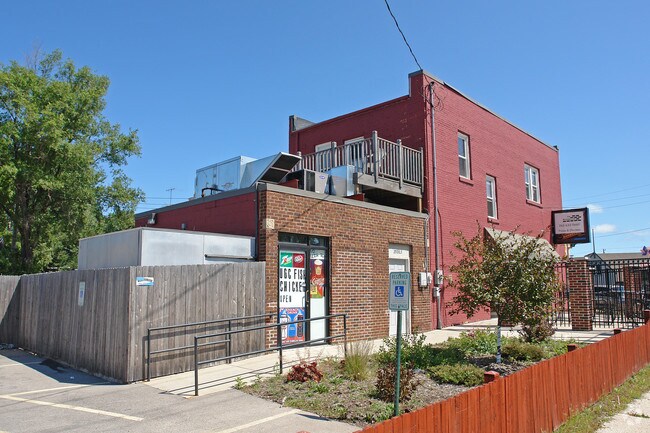
2920 Taylor Ave, Racine, WI 53405


Property Detail
2920 Taylor Ave
276-000013472000
BLK 1 BOULEVARD ADD LOT 17 EXC PT TO R/W AS DESC IN DOC #2479227
Commercialnec
Racine
B2
Wisconsin
B and X Area of moderate flood hazard, usually the area between the limits of the 100-year and 500-year floods.
17
2025
0.12 AC
2025
Racine East
000901
Milwaukee/Madison
2,000 SF
Racine-Mount Pleasant, WI
NEARBY LISTINGS FOR SALE OR LEASE
DEMOGRAPHICS near 2920 Taylor Ave
1 mile
3 mile
5 mile
2025 Total Population
15,433
69,626
121,359
2030 Population
15,485
70,111
122,252
Pop Growth 2025-2030
+ 0.34%
+ 0.70%
+ 0.74%
Average Age
40
39
40
2025 Total Households
6,268
28,347
49,263
HH Growth 2025-2030
+ 0.30%
+ 0.69%
+ 0.72%
Median Household Inc
$61,926
$62,923
$65,903
Avg Household Size
2.40
2.30
2.30
2025 Avg HH Vehicles
2.00
2.00
2.00
Median Home Value
$168,241
$176,786
$195,958
Median Year Built
1956
1957
1963
Nearby Places
Map Layers
Map Styles
 Street
 Aerial
Layers
 Traffic
 Biking
Places
Listings with unknown addresses are not visible on the map
- Restaurants
- Banks
- Shops
- Fitness
- Groceries
PUBLIC TRANSPORTATION
COMMUTER RAIL
Drive
Walk
Distance
13 min
6.6 mi
Kenosha Station (Union Pacific North Line - Northeast Illinois Regional Commuter Railroad (Metra))
Drive
Walk
Distance
Kenosha Station (Union Pacific North Line - Northeast Illinois Regional Commuter Railroad (Metra))
17 min
9.3 mi
AIRPORT
General Mitchell International
Drive
Walk
Distance
General Mitchell International
37 min
25.6 mi
Freight Ports
Port Milwaukee
Drive
Walk
Distance
Port Milwaukee
41 min
29.5 mi
SALE & LEASE HISTORY
LISTING DATE
SALE/LEASE

Mar 03, 2024
For Sale
Nearby Properties
Address
Land Use
TOTAL SIZE
Lot Size
Zoning
Address
Land Use
TOTAL SIZE
Lot Size
Zoning
22.34 AC
Address
Land Use
TOTAL SIZE
Lot Size
Zoning
Address
Land Use
TOTAL SIZE
Lot Size
Zoning
47.01 AC
M-1
Address
Land Use
TOTAL SIZE
Lot Size
Zoning
61,744 SF
42.23 AC
OI
Address
Land Use
TOTAL SIZE
Lot Size
Zoning
14.11 AC
I2
Address
Land Use
TOTAL SIZE
Lot Size
Zoning
180,831 SF
1.49 AC
B4
Address
Land Use
TOTAL SIZE
Lot Size
Zoning
22.98 AC
M-1
Address
Land Use
TOTAL SIZE
Lot Size
Zoning
19.77 AC
B-3
Address
Land Use
TOTAL SIZE
Lot Size
Zoning
9,982 SF
0.39 AC
B4
Address
Land Use
TOTAL SIZE
Lot Size
Zoning
15.81 AC
Address
Land Use
TOTAL SIZE
Lot Size
Zoning
6.77 AC
PUL
Address
Land Use
TOTAL SIZE
Lot Size
Zoning
33.40 AC
I2
Address
Land Use
TOTAL SIZE
Lot Size
Zoning
27.11 AC
B-3
Address
Land Use
TOTAL SIZE
Lot Size
Zoning
164,201 SF
17 AC
B2
Address
Land Use
TOTAL SIZE
Lot Size
Zoning
3.54 AC
B4
Address
Land Use
TOTAL SIZE
Lot Size
Zoning
98.81 AC
Address
Land Use
TOTAL SIZE
Lot Size
Zoning
Address
Land Use
TOTAL SIZE
Lot Size
Zoning
Address
Land Use
TOTAL SIZE
Lot Size
Zoning
Address
Land Use
TOTAL SIZE
Lot Size
Zoning
Address
Land Use
TOTAL SIZE
Lot Size
Zoning
Address
Land Use
TOTAL SIZE
Lot Size
Zoning
58,485 SF
19.71 AC
I2
Address
Land Use
TOTAL SIZE
Lot Size
Zoning
22.72 AC
Address
Land Use
TOTAL SIZE
Lot Size
Zoning
76.18 AC
Address
Land Use
TOTAL SIZE
Lot Size
Zoning
Address
Land Use
TOTAL SIZE
Lot Size
Zoning
Address
Land Use
TOTAL SIZE
Lot Size
Zoning
11.70 AC
M-1
Address
Land Use
TOTAL SIZE
Lot Size
Zoning
18.93 AC
Address
Land Use
TOTAL SIZE
Lot Size
Zoning
Address
Land Use
TOTAL SIZE
Lot Size
Zoning
23.15 AC
I2
The World's #1 Commercial Real Estate Marketplace
Connect with us
© 2026 CoStar Group
The information above has been obtained from sources believed reliable. While we do not doubt its accuracy we have not verified it and make no guarantee, warranty or representation about it. It is your responsibility to independently confirm its accuracy and completeness. Any projections, opinions, assumptions, or estimates used are for example only and do not represent the current or future performance of the property. The value of this transaction to you depends on tax and other factors which should be evaluated by your tax, financial, and legal advisors. You and your advisors should conduct a careful, independent investigation of the property to determine to your satisfaction the suitability of the property for your needs.