Property Record
29202 Ralph Fair Rd, Boerne, TX 78015
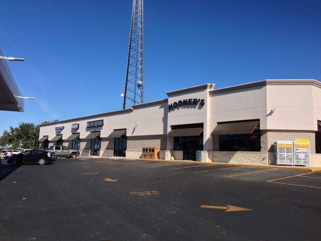

Property Detail
29202 Ralph Fair Rd
San Antonio-New Braunfels, TX
CB 4741C BLK 1 LOT 1 (RFR SUBD)
04741-301-0010
Bexar
Servicestation
Texas
B and X Area of moderate flood hazard, usually the area between the limits of the 100-year and 500-year floods.
1
2025
1.89 AC
2025
Far North Central
182101
San Antonio
35,876 SF
NEARBY LISTINGS FOR SALE OR LEASE
DEMOGRAPHICS near 29202 Ralph Fair Rd
1 mile
3 mile
5 mile
2025 Total Population
1,816
20,505
43,382
2030 Population
1,916
22,107
46,845
Pop Growth 2025-2030
+ 5.51%
+ 7.81%
+ 7.98%
Average Age
47
40
40
2025 Total Households
678
7,143
15,109
HH Growth 2025-2030
+ 5.75%
+ 8.04%
+ 8.19%
Median Household Inc
$176,315
$143,616
$142,354
Avg Household Size
2.60
2.90
2.90
2025 Avg HH Vehicles
2.00
2.00
2.00
Median Home Value
$545,389
$487,402
$511,338
Median Year Built
1995
2010
2010
Nearby Places
Map Layers
Map Styles
 Street
 Aerial
Layers
 Traffic
 Biking
Places
Listings with unknown addresses are not visible on the map
- Restaurants
- Banks
- Shops
- Fitness
- Groceries
PUBLIC TRANSPORTATION
AIRPORT
San Antonio International
Drive
Walk
Distance
San Antonio International
30 min
22.6 mi
SALE & LEASE HISTORY
LISTING DATE
SALE/LEASE

Sep 25, 2016
For Lease
Oct 11, 2016
For Lease
Nearby Properties
Address
Land Use
TOTAL SIZE
Lot Size
Zoning
Address
Land Use
TOTAL SIZE
Lot Size
Zoning
Address
Land Use
TOTAL SIZE
Lot Size
Zoning
282,991 SF
26.41 AC
Address
Land Use
TOTAL SIZE
Lot Size
Zoning
265,093 SF
12.55 AC
Address
Land Use
TOTAL SIZE
Lot Size
Zoning
255,907 SF
19.93 AC
Address
Land Use
TOTAL SIZE
Lot Size
Zoning
215,736 SF
10.06 AC
Address
Land Use
TOTAL SIZE
Lot Size
Zoning
49,164 SF
11.98 AC
Address
Land Use
TOTAL SIZE
Lot Size
Zoning
46,562 SF
3.02 AC
Address
Land Use
TOTAL SIZE
Lot Size
Zoning
91,013 SF
6.45 AC
Address
Land Use
TOTAL SIZE
Lot Size
Zoning
43,422 SF
6.38 AC
Address
Land Use
TOTAL SIZE
Lot Size
Zoning
71,658 SF
16.58 AC
Address
Land Use
TOTAL SIZE
Lot Size
Zoning
930.30 AC
Address
Land Use
TOTAL SIZE
Lot Size
Zoning
159.74 AC
Address
Land Use
TOTAL SIZE
Lot Size
Zoning
103,963 SF
1.98 AC
Address
Land Use
TOTAL SIZE
Lot Size
Zoning
42,442 SF
119.10 AC
Address
Land Use
TOTAL SIZE
Lot Size
Zoning
30,900 SF
3.20 AC
Address
Land Use
TOTAL SIZE
Lot Size
Zoning
20,558 SF
3.50 AC
Address
Land Use
TOTAL SIZE
Lot Size
Zoning
12,840 SF
30.16 AC
Address
Land Use
TOTAL SIZE
Lot Size
Zoning
16,700 SF
3.21 AC
Address
Land Use
TOTAL SIZE
Lot Size
Zoning
12,091 SF
2.10 AC
Address
Land Use
TOTAL SIZE
Lot Size
Zoning
13,434 SF
16.98 AC
Address
Land Use
TOTAL SIZE
Lot Size
Zoning
6,847 SF
39.56 AC
Address
Land Use
TOTAL SIZE
Lot Size
Zoning
5,000 SF
13.37 AC
Address
Land Use
TOTAL SIZE
Lot Size
Zoning
97.16 AC
Address
Land Use
TOTAL SIZE
Lot Size
Zoning
11,508 SF
1.02 AC
Address
Land Use
TOTAL SIZE
Lot Size
Zoning
12,694 SF
1.75 AC
Address
Land Use
TOTAL SIZE
Lot Size
Zoning
48.38 AC
Address
Land Use
TOTAL SIZE
Lot Size
Zoning
29,289 SF
8.91 AC
Address
Land Use
TOTAL SIZE
Lot Size
Zoning
51,460 SF
5 AC
Address
Land Use
TOTAL SIZE
Lot Size
Zoning
44,840 SF
1.83 AC
The World's #1 Commercial Real Estate Marketplace
Connect with us
© 2026 CoStar Group
The information above has been obtained from sources believed reliable. While we do not doubt its accuracy we have not verified it and make no guarantee, warranty or representation about it. It is your responsibility to independently confirm its accuracy and completeness. Any projections, opinions, assumptions, or estimates used are for example only and do not represent the current or future performance of the property. The value of this transaction to you depends on tax and other factors which should be evaluated by your tax, financial, and legal advisors. You and your advisors should conduct a careful, independent investigation of the property to determine to your satisfaction the suitability of the property for your needs.