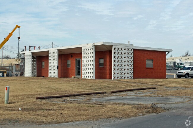
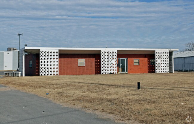
Property Record
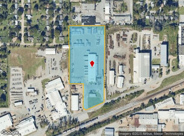
2921 Dawson Rd, Tulsa, OK 74110
NEARBY LISTINGS FOR SALE OR LEASE
Property Detail
2921 Dawson Rd
90332-03-32-20710
Unplatted
Warehouse
BEG 456.5S NWC NE NE TH S197.86 E8.37 S406.24 E150.88 S227.50 TO PT ON CRV LF51.58 NE206.41 N785.21 W369.06 POB SEC 32 20 13 6.261ACS
X
Tulsa
40143C0240L
Oklahoma
2025
6.26 AC
2025
Northeast
001400
Tulsa
14,825 SF
Tulsa, OK
DEMOGRAPHICS near 2921 Dawson Rd
1 mile
3 mile
5 mile
2024 Total Population
15,069
84,034
172,720
2029 Population
15,744
88,079
180,179
Pop Growth 2024-2029
+ 4.48%
+ 4.81%
+ 4.32%
Average Age
34
36
38
2024 Total Households
5,231
32,713
72,081
HH Growth 2024-2029
+ 4.53%
+ 5.09%
+ 4.48%
Median Household Inc
$35,151
$41,583
$46,429
Avg Household Size
2.70
2.30
2.20
2024 Avg HH Vehicles
2.00
2.00
2.00
Median Home Value
$59,961
$97,258
$141,385
Median Year Built
1952
1953
1957
Nearby Places
Map Layers
Map Styles
 Street
 Aerial
Transit
 Traffic
 Biking
Places
Listings with unknown addresses are not visible on the map
- Restaurants
- Banks
- Shops
- Fitness
- Groceries
PUBLIC TRANSPORTATION
AIRPORT
Tulsa International
Drive
Walk
Distance
Tulsa International
13 min
6.0 mi
Freight Ports
Drive
Walk
Distance
23 min
14.2 mi
Nearby Properties
Address
Land Use
TOTAL SIZE
Lot Size
Zoning
Address
Land Use
TOTAL SIZE
Lot Size
Zoning
1,604,892 SF
208.96 AC
AG
Address
Land Use
TOTAL SIZE
Lot Size
Zoning
1,673,798 SF
90.26 AC
NCU
Address
Land Use
TOTAL SIZE
Lot Size
Zoning
692,068 SF
1.03 AC
CBD
Address
Land Use
TOTAL SIZE
Lot Size
Zoning
528,432 SF
0.01 AC
CBD
Address
Land Use
TOTAL SIZE
Lot Size
Zoning
110,922 SF
1.59 AC
RM2
Address
Land Use
TOTAL SIZE
Lot Size
Zoning
254,800 SF
2.07 AC
CBD
Address
Land Use
TOTAL SIZE
Lot Size
Zoning
87,606 SF
8.25 AC
CBD
Address
Land Use
TOTAL SIZE
Lot Size
Zoning
92,407 SF
6.02 AC
CS
Address
Land Use
TOTAL SIZE
Lot Size
Zoning
175,176 SF
1.57 AC
RM2
Address
Land Use
TOTAL SIZE
Lot Size
Zoning
230,620 SF
16.72 AC
RM2
Address
Land Use
TOTAL SIZE
Lot Size
Zoning
266,944 SF
2.07 AC
CBD
Address
Land Use
TOTAL SIZE
Lot Size
Zoning
94,115 SF
15.18 AC
IM
Address
Land Use
TOTAL SIZE
Lot Size
Zoning
56,049 SF
1.14 AC
CBD
Address
Land Use
TOTAL SIZE
Lot Size
Zoning
161,670 SF
8.57 AC
IL
Address
Land Use
TOTAL SIZE
Lot Size
Zoning
1,264,325 SF
10.72 AC
CH
Address
Land Use
TOTAL SIZE
Lot Size
Zoning
106,579 SF
6.76 AC
RM1
Address
Land Use
TOTAL SIZE
Lot Size
Zoning
53,337 SF
3.34 AC
FBC
Address
Land Use
TOTAL SIZE
Lot Size
Zoning
60,320 SF
5.23 AC
NCU
Address
Land Use
TOTAL SIZE
Lot Size
Zoning
1,298,531 SF
2.49 AC
CBD
Address
Land Use
TOTAL SIZE
Lot Size
Zoning
163,321 SF
10.74 AC
RS3
Address
Land Use
TOTAL SIZE
Lot Size
Zoning
63,384 SF
0.56 AC
OH
Address
Land Use
TOTAL SIZE
Lot Size
Zoning
195,492 SF
17.11 AC
RM1
Address
Land Use
TOTAL SIZE
Lot Size
Zoning
54,684 SF
0.96 AC
CBD
Address
Land Use
TOTAL SIZE
Lot Size
Zoning
51,539 SF
0.96 AC
RM2
Address
Land Use
TOTAL SIZE
Lot Size
Zoning
333,000 SF
1.32 AC
CBD
Address
Land Use
TOTAL SIZE
Lot Size
Zoning
56,476 SF
2.89 AC
RM2
Address
Land Use
TOTAL SIZE
Lot Size
Zoning
105,620 SF
2.55 AC
RM2
Address
Land Use
TOTAL SIZE
Lot Size
Zoning
342,608 SF
2.58 AC
CBD
Address
Land Use
TOTAL SIZE
Lot Size
Zoning
194,615 SF
18.68 AC
RS3
Address
Land Use
TOTAL SIZE
Lot Size
Zoning
38,908 SF
2.39 AC
IM
The World's #1 Commercial Real Estate Marketplace
Connect with us
© 2026 CoStar Group
The information above has been obtained from sources believed reliable. While we do not doubt its accuracy we have not verified it and make no guarantee, warranty or representation about it. It is your responsibility to independently confirm its accuracy and completeness. Any projections, opinions, assumptions, or estimates used are for example only and do not represent the current or future performance of the property. The value of this transaction to you depends on tax and other factors which should be evaluated by your tax, financial, and legal advisors. You and your advisors should conduct a careful, independent investigation of the property to determine to your satisfaction the suitability of the property for your needs.