Property Record
2921 Mcbride Ct, Hamilton, OH 45011
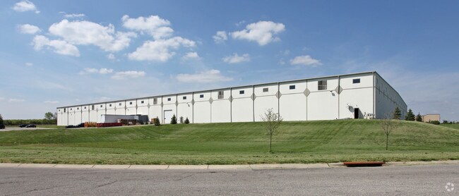
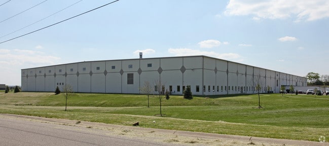

Property Detail
2921 Mcbride Ct
P6461-056-000-036
32441 ENT
Warehouse
BUTLER
B and X Area of moderate flood hazard, usually the area between the limits of the 100-year and 500-year floods.
Ohio
2024
28.23 AC
2025
Tri-County
011004
Cincinnati/Dayton
310,200 SF
Cincinnati, OH-KY-IN
NEARBY LISTINGS FOR SALE OR LEASE
DEMOGRAPHICS near 2921 Mcbride Ct
1 mile
3 mile
5 mile
2025 Total Population
5,687
66,604
165,683
2030 Population
5,908
68,551
170,708
Pop Growth 2025-2030
+ 3.89%
+ 2.92%
+ 3.03%
Average Age
37
39
40
2025 Total Households
2,258
24,282
63,251
HH Growth 2025-2030
+ 3.94%
+ 3.03%
+ 3.14%
Median Household Inc
$44,901
$66,776
$78,380
Avg Household Size
2.40
2.60
2.50
2025 Avg HH Vehicles
2.00
2.00
2.00
Median Home Value
$214,338
$229,915
$254,115
Median Year Built
1998
1970
1976
Nearby Places
Map Layers
Map Styles
 Street
 Aerial
Layers
 Traffic
 Biking
Places
Listings with unknown addresses are not visible on the map
- Restaurants
- Banks
- Shops
- Fitness
- Groceries
PUBLIC TRANSPORTATION
AIRPORT
Cincinnati/Northern Kentucky International
Drive
Walk
Distance
Cincinnati/Northern Kentucky International
59 min
37.8 mi
Nearby Properties
Address
Land Use
TOTAL SIZE
Lot Size
Zoning
Address
Land Use
TOTAL SIZE
Lot Size
Zoning
14.65 AC
Address
Land Use
TOTAL SIZE
Lot Size
Zoning
14,559 SF
27.50 AC
Address
Land Use
TOTAL SIZE
Lot Size
Zoning
510,080 SF
60.87 AC
Address
Land Use
TOTAL SIZE
Lot Size
Zoning
112,027 SF
0.78 AC
Address
Land Use
TOTAL SIZE
Lot Size
Zoning
283,527 SF
28.17 AC
Address
Land Use
TOTAL SIZE
Lot Size
Zoning
54.77 AC
Address
Land Use
TOTAL SIZE
Lot Size
Zoning
629,044 SF
35.83 AC
Address
Land Use
TOTAL SIZE
Lot Size
Zoning
28.47 AC
Address
Land Use
TOTAL SIZE
Lot Size
Zoning
319,568 SF
23.73 AC
Address
Land Use
TOTAL SIZE
Lot Size
Zoning
357,452 SF
26.77 AC
Address
Land Use
TOTAL SIZE
Lot Size
Zoning
287,433 SF
23.36 AC
Address
Land Use
TOTAL SIZE
Lot Size
Zoning
Address
Land Use
TOTAL SIZE
Lot Size
Zoning
1,602,242 SF
53.34 AC
Address
Land Use
TOTAL SIZE
Lot Size
Zoning
30.51 AC
Address
Land Use
TOTAL SIZE
Lot Size
Zoning
2.75 AC
Address
Land Use
TOTAL SIZE
Lot Size
Zoning
50,753 SF
19.74 AC
Address
Land Use
TOTAL SIZE
Lot Size
Zoning
0.37 AC
Address
Land Use
TOTAL SIZE
Lot Size
Zoning
215,969 SF
16.08 AC
ADV
Address
Land Use
TOTAL SIZE
Lot Size
Zoning
178,152 SF
63.48 AC
Address
Land Use
TOTAL SIZE
Lot Size
Zoning
147,898 SF
15.34 AC
Address
Land Use
TOTAL SIZE
Lot Size
Zoning
22.02 AC
Address
Land Use
TOTAL SIZE
Lot Size
Zoning
412,814 SF
23.92 AC
Address
Land Use
TOTAL SIZE
Lot Size
Zoning
124,549 SF
9.75 AC
Address
Land Use
TOTAL SIZE
Lot Size
Zoning
462,994 SF
25.63 AC
Address
Land Use
TOTAL SIZE
Lot Size
Zoning
32,000 SF
10.24 AC
Address
Land Use
TOTAL SIZE
Lot Size
Zoning
333,379 SF
22.22 AC
Address
Land Use
TOTAL SIZE
Lot Size
Zoning
162,982 SF
16.96 AC
Address
Land Use
TOTAL SIZE
Lot Size
Zoning
446,660 SF
30.51 AC
Address
Land Use
TOTAL SIZE
Lot Size
Zoning
15.61 AC
Address
Land Use
TOTAL SIZE
Lot Size
Zoning
The World's #1 Commercial Real Estate Marketplace
Connect with us
© 2026 CoStar Group
The information above has been obtained from sources believed reliable. While we do not doubt its accuracy we have not verified it and make no guarantee, warranty or representation about it. It is your responsibility to independently confirm its accuracy and completeness. Any projections, opinions, assumptions, or estimates used are for example only and do not represent the current or future performance of the property. The value of this transaction to you depends on tax and other factors which should be evaluated by your tax, financial, and legal advisors. You and your advisors should conduct a careful, independent investigation of the property to determine to your satisfaction the suitability of the property for your needs.