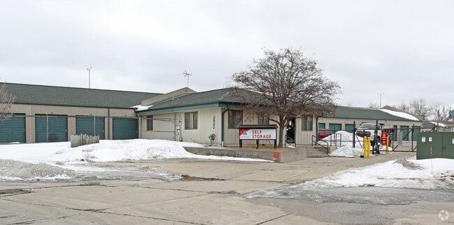
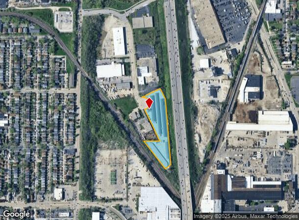
Property Record
2922 S 5Th Ct, Milwaukee, WI 53207

NEARBY LISTINGS FOR SALE OR LEASE
Property Detail
2922 S 5Th Ct
Milwaukee-Waukesha-West Allis, WI
Freeway Industrial Park
506-0110-122
FREEWAY INDUSTRIAL PARK IN SE 1/4 SEC 8-6-22 BLOCK 3 LOTS 9 & 10 & VAC ST ADJ & LANDS ADJ ON S COM SE COR SD LOT 9-TH W 290 TO PT ON NELY RR ROW LI-TH SELY ALG SD RR ROW LI 414 TO WLY LI X-WAY ROW-TH NELY 79.45 TO WLY LI X-WAY ROW-TH NLY 282 ALG SD X
Publicstorage
Milwaukee
X
Wisconsin
55079C0156E
9,10
2024
3.75 AC
2024
Milwaukee Near SW
018500
Milwaukee/Madison
59,900 SF
DEMOGRAPHICS near 2922 S 5Th Ct
1 Mile
3 Mile
5 Mile
2024 Total Population
27,603
159,347
351,307
2029 Population
26,874
155,416
343,668
Pop Growth 2024-2029
(2.64%)
(2.47%)
(2.17%)
Average Age
34
36
37
2024 Total Households
10,285
61,723
151,116
HH Growth 2024-2029
(2.76%)
(2.48%)
(2.11%)
Median Household Inc
$56,171
$51,411
$53,065
Avg Household Size
2.60
2.50
2.20
2024 Avg HH Vehicles
2.00
2.00
1.00
Median Home Value
$161,614
$170,552
$181,675
Median Year Built
1946
1948
1952
Nearby Places
Map Layers
Map Styles
 Street
 Aerial
- Restaurants
- Banks
- Shops
- Fitness
- Groceries
PUBLIC TRANSPORTATION
COMMUTER RAIL
DRIVE
WALK
Distance
10 min
4.1 mi
DRIVE
WALK
Distance
12 min
4.2 mi
AIRPORT
General Mitchell International
DRIVE
WALK
Distance
General Mitchell International
12 min
4.2 mi
Nearby Properties
Address
Land Use
TOTAL SIZE
Lot Size
Zoning
Address
Land Use
TOTAL SIZE
Lot Size
Zoning
41.05 AC
IO2
Address
Land Use
TOTAL SIZE
Lot Size
Zoning
523,726 SF
0.79 AC
C9B(B)
Address
Land Use
TOTAL SIZE
Lot Size
Zoning
607,577 SF
1.67 AC
PD
Address
Land Use
TOTAL SIZE
Lot Size
Zoning
173,610 SF
1.70 AC
IM
Address
Land Use
TOTAL SIZE
Lot Size
Zoning
319,559 SF
6.29 AC
PD
Address
Land Use
TOTAL SIZE
Lot Size
Zoning
179 AC
IH
Address
Land Use
TOTAL SIZE
Lot Size
Zoning
204,809 SF
1.04 AC
IM
Address
Land Use
TOTAL SIZE
Lot Size
Zoning
245,485 SF
6.30 AC
IM
Address
Land Use
TOTAL SIZE
Lot Size
Zoning
1,709,128 SF
9.32 AC
PD
Address
Land Use
TOTAL SIZE
Lot Size
Zoning
12.02 AC
IO2
Address
Land Use
TOTAL SIZE
Lot Size
Zoning
15.43 AC
PD
Address
Land Use
TOTAL SIZE
Lot Size
Zoning
48.34 AC
IO1
Address
Land Use
TOTAL SIZE
Lot Size
Zoning
122,695 SF
0.39 AC
C9G
Address
Land Use
TOTAL SIZE
Lot Size
Zoning
2.85 AC
C9G
Address
Land Use
TOTAL SIZE
Lot Size
Zoning
110,000 SF
7.59 AC
TL
Address
Land Use
TOTAL SIZE
Lot Size
Zoning
2,610 SF
1.04 AC
IM
Address
Land Use
TOTAL SIZE
Lot Size
Zoning
86.13 AC
IH
Address
Land Use
TOTAL SIZE
Lot Size
Zoning
11.38 AC
TL
Address
Land Use
TOTAL SIZE
Lot Size
Zoning
120,000 SF
1.10 AC
IM
Address
Land Use
TOTAL SIZE
Lot Size
Zoning
222,100 SF
1.29 AC
PD
Address
Land Use
TOTAL SIZE
Lot Size
Zoning
197,354 SF
18 AC
CS
Address
Land Use
TOTAL SIZE
Lot Size
Zoning
0.43 AC
RT3
Address
Land Use
TOTAL SIZE
Lot Size
Zoning
183,291 SF
11.48 AC
IM
Address
Land Use
TOTAL SIZE
Lot Size
Zoning
95,788 SF
1.04 AC
IM
Address
Land Use
TOTAL SIZE
Lot Size
Zoning
Address
Land Use
TOTAL SIZE
Lot Size
Zoning
188,328 SF
22.41 AC
PD
Address
Land Use
TOTAL SIZE
Lot Size
Zoning
17.47 AC
R2
Address
Land Use
TOTAL SIZE
Lot Size
Zoning
39.81 AC
Address
Land Use
TOTAL SIZE
Lot Size
Zoning
122,602 SF
0.89 AC
IM
Address
Land Use
TOTAL SIZE
Lot Size
Zoning
216,289 SF
1.06 AC
IM
The World's #1 Commercial Real Estate Marketplace
Connect with us
© 2025 CoStar Group
The information above has been obtained from sources believed reliable. While we do not doubt its accuracy we have not verified it and make no guarantee, warranty or representation about it. It is your responsibility to independently confirm its accuracy and completeness. Any projections, opinions, assumptions, or estimates used are for example only and do not represent the current or future performance of the property. The value of this transaction to you depends on tax and other factors which should be evaluated by your tax, financial, and legal advisors. You and your advisors should conduct a careful, independent investigation of the property to determine to your satisfaction the suitability of the property for your needs.