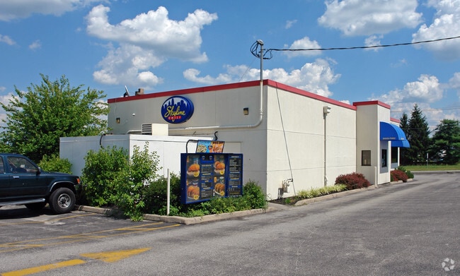
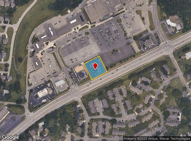
Property Record
2922 W Us Highway 22 And 3, Maineville, OH 45039
NEARBY LISTINGS FOR SALE OR LEASE
Property Detail
2922 W Us Highway 22 And 3
Cincinnati, OH-KY-IN
Landen Square 1
16-15-301-023
LANDEN SQUARE 1 LOT PT.1
Restaurantdrivein
Warren
X
Ohio
39165C0217F
1
2024
0.68 AC
2024
Mason/Montgomery
032203
Cincinnati/Dayton
2,253 SF
DEMOGRAPHICS near 2922 W Us Highway 22 And 3
1 Mile
3 Mile
5 Mile
2024 Total Population
10,310
55,974
141,819
2029 Population
11,201
59,778
150,356
Pop Growth 2024-2029
+ 8.64%
+ 6.80%
+ 6.02%
Average Age
41
40
40
2024 Total Households
4,180
22,122
53,332
HH Growth 2024-2029
+ 8.68%
+ 6.84%
+ 5.96%
Median Household Inc
$102,148
$101,322
$107,522
Avg Household Size
2.40
2.50
2.60
2024 Avg HH Vehicles
2.00
2.00
2.00
Median Home Value
$258,352
$301,176
$303,194
Median Year Built
1985
1993
1992
Nearby Places
Map Layers
Map Styles
 Street
 Aerial
- Restaurants
- Banks
- Shops
- Fitness
- Groceries
PUBLIC TRANSPORTATION
AIRPORT
Cincinnati/Northern Kentucky International
DRIVE
WALK
Distance
Cincinnati/Northern Kentucky International
57 min
35.9 mi
Freight Ports
Port of Toledo
DRIVE
WALK
Distance
Port of Toledo
228 min
191.6 mi
Nearby Properties
Address
Land Use
TOTAL SIZE
Lot Size
Zoning
Address
Land Use
TOTAL SIZE
Lot Size
Zoning
232.72 AC
Address
Land Use
TOTAL SIZE
Lot Size
Zoning
232.72 AC
Address
Land Use
TOTAL SIZE
Lot Size
Zoning
274,436 SF
27.12 AC
Address
Land Use
TOTAL SIZE
Lot Size
Zoning
590.28 AC
Address
Land Use
TOTAL SIZE
Lot Size
Zoning
219,265 SF
41.57 AC
Address
Land Use
TOTAL SIZE
Lot Size
Zoning
10.25 AC
Address
Land Use
TOTAL SIZE
Lot Size
Zoning
126,400 SF
31.44 AC
Address
Land Use
TOTAL SIZE
Lot Size
Zoning
17,484 SF
35.55 AC
Address
Land Use
TOTAL SIZE
Lot Size
Zoning
168,776 SF
63 AC
Address
Land Use
TOTAL SIZE
Lot Size
Zoning
80,767 SF
7.31 AC
Address
Land Use
TOTAL SIZE
Lot Size
Zoning
4,190 SF
36 AC
Address
Land Use
TOTAL SIZE
Lot Size
Zoning
47,424 SF
32.35 AC
Address
Land Use
TOTAL SIZE
Lot Size
Zoning
67,636 SF
8.74 AC
Address
Land Use
TOTAL SIZE
Lot Size
Zoning
12,761 SF
47.72 AC
Address
Land Use
TOTAL SIZE
Lot Size
Zoning
71,866 SF
14.33 AC
Address
Land Use
TOTAL SIZE
Lot Size
Zoning
42,906 SF
23.76 AC
Address
Land Use
TOTAL SIZE
Lot Size
Zoning
40.92 AC
Address
Land Use
TOTAL SIZE
Lot Size
Zoning
140,876 SF
64.04 AC
Address
Land Use
TOTAL SIZE
Lot Size
Zoning
25,339 SF
14.59 AC
Address
Land Use
TOTAL SIZE
Lot Size
Zoning
12,102 SF
8.17 AC
Address
Land Use
TOTAL SIZE
Lot Size
Zoning
211,734 SF
18.14 AC
Address
Land Use
TOTAL SIZE
Lot Size
Zoning
37,906 SF
8.94 AC
Address
Land Use
TOTAL SIZE
Lot Size
Zoning
45,435 SF
22.94 AC
Address
Land Use
TOTAL SIZE
Lot Size
Zoning
26.04 AC
DD
Address
Land Use
TOTAL SIZE
Lot Size
Zoning
1,248 SF
21.67 AC
Address
Land Use
TOTAL SIZE
Lot Size
Zoning
116,775 SF
12.37 AC
Address
Land Use
TOTAL SIZE
Lot Size
Zoning
41,329 SF
22.94 AC
Address
Land Use
TOTAL SIZE
Lot Size
Zoning
2,173 SF
22 AC
E
Address
Land Use
TOTAL SIZE
Lot Size
Zoning
85,759 SF
13.80 AC
Address
Land Use
TOTAL SIZE
Lot Size
Zoning
30,844 SF
15.87 AC
The World's #1 Commercial Real Estate Marketplace
Connect with us
© 2025 CoStar Group
The information above has been obtained from sources believed reliable. While we do not doubt its accuracy we have not verified it and make no guarantee, warranty or representation about it. It is your responsibility to independently confirm its accuracy and completeness. Any projections, opinions, assumptions, or estimates used are for example only and do not represent the current or future performance of the property. The value of this transaction to you depends on tax and other factors which should be evaluated by your tax, financial, and legal advisors. You and your advisors should conduct a careful, independent investigation of the property to determine to your satisfaction the suitability of the property for your needs.