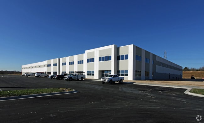
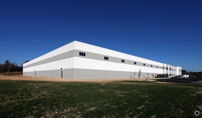
Property Record
2925 Chief Ct, Dallas, NC 28034

Property Detail
2925 Chief Ct
220177
GASTONIA TECHNOLOGY PARK L 6 13 099 003 02 000
Industrialgeneral
Gaston
B and X Area of moderate flood hazard, usually the area between the limits of the 100-year and 500-year floods.
North Carolina
2025
16.19 AC
2025
Gaston County
030404
Charlotte
176,657 SF
Charlotte-Concord-Gastonia, NC-SC
NEARBY LISTINGS FOR SALE OR LEASE
DEMOGRAPHICS near 2925 Chief Ct
1 mile
3 mile
5 mile
2025 Total Population
703
28,192
78,285
2030 Population
748
29,843
82,391
Pop Growth 2025-2030
+ 6.40%
+ 5.86%
+ 5.24%
Average Age
41
38
39
2025 Total Households
238
10,830
30,881
HH Growth 2025-2030
+ 6.72%
+ 6.09%
+ 5.41%
Median Household Inc
$59,545
$51,922
$55,438
Avg Household Size
2.50
2.50
2.40
2025 Avg HH Vehicles
3.00
2.00
2.00
Median Home Value
$328,767
$239,057
$234,927
Median Year Built
1971
1976
1972
Nearby Places
Map Layers
Map Styles
 Street
 Aerial
Transit
 Traffic
 Biking
Places
Listings with unknown addresses are not visible on the map
- Restaurants
- Banks
- Shops
- Fitness
- Groceries
PUBLIC TRANSPORTATION
COMMUTER RAIL
Gastonia Amtrak Station (Crescent - Amtrak)
Drive
Walk
Distance
Gastonia Amtrak Station (Crescent - Amtrak)
12 min
5.4 mi
AIRPORT
Charlotte/Douglas International
Drive
Walk
Distance
Charlotte/Douglas International
37 min
20.1 mi
Concord-Padgett Regional
Drive
Walk
Distance
Concord-Padgett Regional
51 min
36.5 mi
Freight Ports
North Charleston Terminal
Drive
Walk
Distance
North Charleston Terminal
251 min
216.2 mi
Nearby Properties
Address
Land Use
TOTAL SIZE
Lot Size
Zoning
Address
Land Use
TOTAL SIZE
Lot Size
Zoning
56,000 SF
23.22 AC
GOV01
Address
Land Use
TOTAL SIZE
Lot Size
Zoning
11,696 SF
159.68 AC
Address
Land Use
TOTAL SIZE
Lot Size
Zoning
159,263 SF
9.83 AC
GOV01
Address
Land Use
TOTAL SIZE
Lot Size
Zoning
17.37 AC
Address
Land Use
TOTAL SIZE
Lot Size
Zoning
312,465 SF
35.23 AC
Address
Land Use
TOTAL SIZE
Lot Size
Zoning
192,315 SF
44.12 AC
INDS1
Address
Land Use
TOTAL SIZE
Lot Size
Zoning
2,688 SF
22.48 AC
OFF01
Address
Land Use
TOTAL SIZE
Lot Size
Zoning
2,250 SF
27.79 AC
OFF01
Address
Land Use
TOTAL SIZE
Lot Size
Zoning
539,988 SF
36.32 AC
STOR6
Address
Land Use
TOTAL SIZE
Lot Size
Zoning
Address
Land Use
TOTAL SIZE
Lot Size
Zoning
123,948 SF
6.94 AC
GOV05
Address
Land Use
TOTAL SIZE
Lot Size
Zoning
0.79 AC
RET01
Address
Land Use
TOTAL SIZE
Lot Size
Zoning
411,076 SF
67.01 AC
INDS2
Address
Land Use
TOTAL SIZE
Lot Size
Zoning
154,681 SF
63.07 AC
INDS1
Address
Land Use
TOTAL SIZE
Lot Size
Zoning
1,760 SF
3.51 AC
Address
Land Use
TOTAL SIZE
Lot Size
Zoning
163,100 SF
41.60 AC
INDS1
Address
Land Use
TOTAL SIZE
Lot Size
Zoning
57,880 SF
5.99 AC
GOV05
Address
Land Use
TOTAL SIZE
Lot Size
Zoning
16,776 SF
49.87 AC
PUB01
Address
Land Use
TOTAL SIZE
Lot Size
Zoning
148,300 SF
12.59 AC
INDS2
Address
Land Use
TOTAL SIZE
Lot Size
Zoning
1,914 SF
15.78 AC
MRKT1
Address
Land Use
TOTAL SIZE
Lot Size
Zoning
12.25 AC
Address
Land Use
TOTAL SIZE
Lot Size
Zoning
514,404 SF
27.84 AC
INDS2
Address
Land Use
TOTAL SIZE
Lot Size
Zoning
33,134 SF
6.80 AC
Address
Land Use
TOTAL SIZE
Lot Size
Zoning
3,328 SF
10.16 AC
APT02
Address
Land Use
TOTAL SIZE
Lot Size
Zoning
20,160 SF
18.47 AC
PUB01
Address
Land Use
TOTAL SIZE
Lot Size
Zoning
44,224 SF
3.32 AC
Address
Land Use
TOTAL SIZE
Lot Size
Zoning
4,228 SF
11.39 AC
APT02
Address
Land Use
TOTAL SIZE
Lot Size
Zoning
2,776 SF
57.41 AC
R1
Address
Land Use
TOTAL SIZE
Lot Size
Zoning
3,832 SF
36.55 AC
The World's #1 Commercial Real Estate Marketplace
Connect with us
© 2026 CoStar Group
The information above has been obtained from sources believed reliable. While we do not doubt its accuracy we have not verified it and make no guarantee, warranty or representation about it. It is your responsibility to independently confirm its accuracy and completeness. Any projections, opinions, assumptions, or estimates used are for example only and do not represent the current or future performance of the property. The value of this transaction to you depends on tax and other factors which should be evaluated by your tax, financial, and legal advisors. You and your advisors should conduct a careful, independent investigation of the property to determine to your satisfaction the suitability of the property for your needs.