Property Record
2925 E State Highway 76, Branson, MO 65616
NEARBY LISTINGS FOR SALE OR LEASE
-
-
View all Branson listings for sale on LoopNet.com
Property Detail
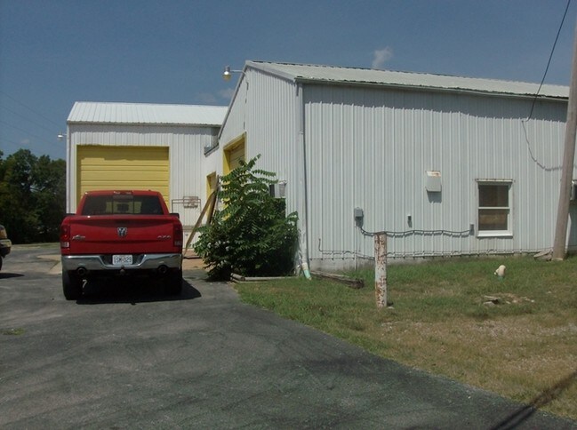
2925 E State Highway 76
17-1.0-02-002-001-030.001
Country Club Heights
Commercialnec
COUNTRY CLUB HEIGHTS- LT 3A, BLK 5, AMDED PLAT OF
X
Taney
29213C0170E
Missouri
2024
3a
2025
0.74 AC
480301
Other Market Areas
4,080 SF
Branson, MO
DEMOGRAPHICS near 2925 E State Highway 76
1 Mile
3 Mile
5 Mile
2024 Total Population
1,262
12,856
27,400
2029 Population
1,299
13,097
27,889
Pop Growth 2024-2029
+ 2.93%
+ 1.87%
+ 1.78%
Average Age
42
39
40
2024 Total Households
524
4,757
10,700
HH Growth 2024-2029
+ 3.24%
+ 1.79%
+ 1.63%
Median Household Inc
$55,181
$51,589
$51,056
Avg Household Size
2.40
2.30
2.30
2024 Avg HH Vehicles
2.00
2.00
2.00
Median Home Value
$179,779
$163,443
$172,117
Median Year Built
1994
1991
1993
Nearby Places
Map Layers
Map Styles
 Street
 Aerial
- Restaurants
- Banks
- Shops
- Fitness
- Groceries
Nearby Properties
Address
Land Use
TOTAL SIZE
Lot Size
Zoning
Address
Land Use
TOTAL SIZE
Lot Size
Zoning
66,272 SF
7.83 AC
Address
Land Use
TOTAL SIZE
Lot Size
Zoning
59,939 SF
15.76 AC
Address
Land Use
TOTAL SIZE
Lot Size
Zoning
Address
Land Use
TOTAL SIZE
Lot Size
Zoning
19,872 SF
2.97 AC
Address
Land Use
TOTAL SIZE
Lot Size
Zoning
63,169 SF
22.17 AC
Address
Land Use
TOTAL SIZE
Lot Size
Zoning
24,176 SF
10.28 AC
Address
Land Use
TOTAL SIZE
Lot Size
Zoning
34,856 SF
15.68 AC
Address
Land Use
TOTAL SIZE
Lot Size
Zoning
47,021 SF
5.20 AC
Address
Land Use
TOTAL SIZE
Lot Size
Zoning
24,578 SF
16.15 AC
Address
Land Use
TOTAL SIZE
Lot Size
Zoning
46,797 SF
1.67 AC
Address
Land Use
TOTAL SIZE
Lot Size
Zoning
Address
Land Use
TOTAL SIZE
Lot Size
Zoning
11.46 AC
Address
Land Use
TOTAL SIZE
Lot Size
Zoning
Address
Land Use
TOTAL SIZE
Lot Size
Zoning
17,228 SF
2.24 AC
Address
Land Use
TOTAL SIZE
Lot Size
Zoning
31,513 SF
2.93 AC
Address
Land Use
TOTAL SIZE
Lot Size
Zoning
27,951 SF
0.91 AC
Address
Land Use
TOTAL SIZE
Lot Size
Zoning
32,312 SF
1.03 AC
Address
Land Use
TOTAL SIZE
Lot Size
Zoning
19,984 SF
2.59 AC
Address
Land Use
TOTAL SIZE
Lot Size
Zoning
29,471 SF
Address
Land Use
TOTAL SIZE
Lot Size
Zoning
3,374 SF
0.95 AC
Address
Land Use
TOTAL SIZE
Lot Size
Zoning
27,431 SF
Address
Land Use
TOTAL SIZE
Lot Size
Zoning
27,514 SF
2.82 AC
Address
Land Use
TOTAL SIZE
Lot Size
Zoning
Address
Land Use
TOTAL SIZE
Lot Size
Zoning
3,522 SF
6.72 AC
Address
Land Use
TOTAL SIZE
Lot Size
Zoning
19,120 SF
0.88 AC
Address
Land Use
TOTAL SIZE
Lot Size
Zoning
23,703 SF
0.61 AC
Address
Land Use
TOTAL SIZE
Lot Size
Zoning
22,315 SF
0.56 AC
Address
Land Use
TOTAL SIZE
Lot Size
Zoning
14,400 SF
2.97 AC
The World's #1 Commercial Real Estate Marketplace
Connect with us
© 2026 CoStar Group
The information above has been obtained from sources believed reliable. While we do not doubt its accuracy we have not verified it and make no guarantee, warranty or representation about it. It is your responsibility to independently confirm its accuracy and completeness. Any projections, opinions, assumptions, or estimates used are for example only and do not represent the current or future performance of the property. The value of this transaction to you depends on tax and other factors which should be evaluated by your tax, financial, and legal advisors. You and your advisors should conduct a careful, independent investigation of the property to determine to your satisfaction the suitability of the property for your needs.