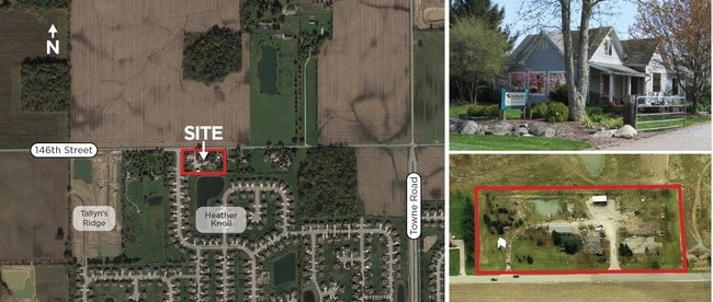
Property Record
2925 W 146Th St, Carmel, IN 46074

NEARBY LISTINGS FOR SALE OR LEASE
Property Detail
2925 W 146Th St
29-09-20-000-009.001-018
ACREAGE 2.62, SECTION 20, TOWNSHIP 18, RANGE 3
Officebuilding
Hamilton
X
Indiana
18057C0205G
2.62 AC
2023
Far North Hamilton Cnty
2024
Indianapolis
110910
Indianapolis-Carmel-Anderson, IN
6,591 SF
DEMOGRAPHICS near 2925 W 146Th St
1 Mile
3 Mile
5 Mile
2024 Total Population
4,256
45,059
103,967
2029 Population
5,162
51,314
118,102
Pop Growth 2024-2029
+ 21.29%
+ 13.88%
+ 13.60%
Average Age
39
37
38
2024 Total Households
1,502
15,342
38,062
HH Growth 2024-2029
+ 21.44%
+ 13.98%
+ 13.69%
Median Household Inc
$125,116
$123,784
$113,813
Avg Household Size
2.70
2.90
2.70
2024 Avg HH Vehicles
2.00
2.00
2.00
Median Home Value
$464,620
$376,949
$398,361
Median Year Built
2011
2006
2005
Nearby Places
Map Layers
Map Styles
 Street
 Aerial
- Restaurants
- Banks
- Shops
- Fitness
- Groceries
PUBLIC TRANSPORTATION
AIRPORT
Indianapolis International
DRIVE
WALK
Distance
Indianapolis International
52 min
28.5 mi
Freight Ports
Port of Toledo
DRIVE
WALK
Distance
Port of Toledo
267 min
219.4 mi
SALE & LEASE HISTORY
LISTING DATE
SALE/LEASE

Mar 14, 2017
For Sale
Nearby Properties
Address
Land Use
TOTAL SIZE
Lot Size
Zoning
Address
Land Use
TOTAL SIZE
Lot Size
Zoning
504,699 SF
40 AC
Address
Land Use
TOTAL SIZE
Lot Size
Zoning
383,016 SF
16.62 AC
Address
Land Use
TOTAL SIZE
Lot Size
Zoning
402,521 SF
153.38 AC
Address
Land Use
TOTAL SIZE
Lot Size
Zoning
257,957 SF
9.06 AC
Address
Land Use
TOTAL SIZE
Lot Size
Zoning
351,756 SF
8.38 AC
Address
Land Use
TOTAL SIZE
Lot Size
Zoning
75,036 SF
22.39 AC
ZO01
Address
Land Use
TOTAL SIZE
Lot Size
Zoning
87,040 SF
24.23 AC
Address
Land Use
TOTAL SIZE
Lot Size
Zoning
114,658 SF
12.66 AC
Address
Land Use
TOTAL SIZE
Lot Size
Zoning
7,843 SF
3.38 AC
ZO01
Address
Land Use
TOTAL SIZE
Lot Size
Zoning
111,176 SF
30 AC
Address
Land Use
TOTAL SIZE
Lot Size
Zoning
58,024 SF
2.31 AC
Address
Land Use
TOTAL SIZE
Lot Size
Zoning
91,837 SF
19.40 AC
Address
Land Use
TOTAL SIZE
Lot Size
Zoning
35,939 SF
4.51 AC
Address
Land Use
TOTAL SIZE
Lot Size
Zoning
3,473 SF
1.13 AC
ZO01
Address
Land Use
TOTAL SIZE
Lot Size
Zoning
26,001 SF
16.91 AC
Address
Land Use
TOTAL SIZE
Lot Size
Zoning
10,730 SF
1.23 AC
ZO01
Address
Land Use
TOTAL SIZE
Lot Size
Zoning
20,240 SF
8.39 AC
Address
Land Use
TOTAL SIZE
Lot Size
Zoning
10,326 SF
1.23 AC
Address
Land Use
TOTAL SIZE
Lot Size
Zoning
34,177 SF
4.10 AC
Address
Land Use
TOTAL SIZE
Lot Size
Zoning
19,306 SF
5.57 AC
Address
Land Use
TOTAL SIZE
Lot Size
Zoning
11,520 SF
66.99 AC
Address
Land Use
TOTAL SIZE
Lot Size
Zoning
15,888 SF
14.32 AC
Address
Land Use
TOTAL SIZE
Lot Size
Zoning
13,908 SF
36.84 AC
Address
Land Use
TOTAL SIZE
Lot Size
Zoning
10,059 SF
2.74 AC
Address
Land Use
TOTAL SIZE
Lot Size
Zoning
1.51 AC
ZO01
Address
Land Use
TOTAL SIZE
Lot Size
Zoning
10,769 SF
1.35 AC
Address
Land Use
TOTAL SIZE
Lot Size
Zoning
11,367 SF
1.30 AC
Address
Land Use
TOTAL SIZE
Lot Size
Zoning
15,066 SF
1.96 AC
Address
Land Use
TOTAL SIZE
Lot Size
Zoning
14,131 SF
1.67 AC
Address
Land Use
TOTAL SIZE
Lot Size
Zoning
13,054 SF
0.48 AC
The World's #1 Commercial Real Estate Marketplace
Connect with us
© 2026 CoStar Group
The information above has been obtained from sources believed reliable. While we do not doubt its accuracy we have not verified it and make no guarantee, warranty or representation about it. It is your responsibility to independently confirm its accuracy and completeness. Any projections, opinions, assumptions, or estimates used are for example only and do not represent the current or future performance of the property. The value of this transaction to you depends on tax and other factors which should be evaluated by your tax, financial, and legal advisors. You and your advisors should conduct a careful, independent investigation of the property to determine to your satisfaction the suitability of the property for your needs.