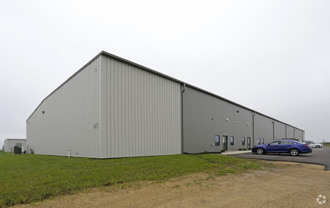
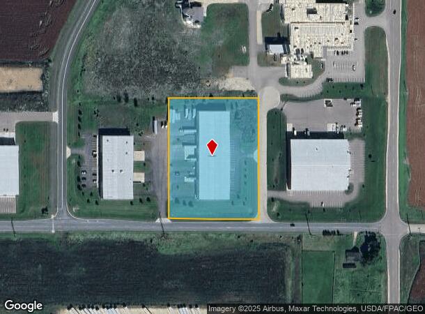
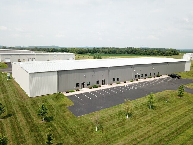
Property Record
2927 61St St, Menomonie, WI 54751

NEARBY LISTINGS FOR SALE OR LEASE
-
-
View all Menomonie listings for lease on LoopNet.com
Property Detail
2927 61St St
Menomonie, WI
PT. SE SE NOW KNOWN AS LOT 8 CSM 4376 VOLUME 21 PAGE 146 RECORDED AS DOCUMENT NUMBER 625856
1725122812084400011
Dunn
Commercialnec
Wisconsin
X
8
55033C0336C
3.99 AC
2024
Eau Claire/Menomonie
2024
Other Market Areas
970500
DEMOGRAPHICS near 2927 61St St
1 Mile
3 Mile
5 Mile
2024 Total Population
13
3,511
20,798
2029 Population
13
3,586
21,447
Pop Growth 2024-2029
0.00%
+ 2.14%
+ 3.12%
Average Age
37
41
37
2024 Total Households
6
1,411
7,775
HH Growth 2024-2029
0.00%
+ 2.27%
+ 3.55%
Median Household Inc
$67,500
$72,831
$59,053
Avg Household Size
1.80
2.30
2.20
2024 Avg HH Vehicles
2.00
2.00
2.00
Median Home Value
$150,000
$231,231
$199,866
Median Year Built
1994
1986
1981
Nearby Places
Map Layers
Map Styles
 Street
 Aerial
- Restaurants
- Banks
- Shops
- Fitness
- Groceries
SALE & LEASE HISTORY
LISTING DATE
SALE/LEASE

Aug 08, 2023
For Lease
Nearby Properties
Address
Land Use
TOTAL SIZE
Lot Size
Zoning
Address
Land Use
TOTAL SIZE
Lot Size
Zoning
124.80 AC
I1
Address
Land Use
TOTAL SIZE
Lot Size
Zoning
50.09 AC
I3
Address
Land Use
TOTAL SIZE
Lot Size
Zoning
70.28 AC
I3
Address
Land Use
TOTAL SIZE
Lot Size
Zoning
20.75 AC
I1
Address
Land Use
TOTAL SIZE
Lot Size
Zoning
22.74 AC
I3
Address
Land Use
TOTAL SIZE
Lot Size
Zoning
30.01 AC
I1
Address
Land Use
TOTAL SIZE
Lot Size
Zoning
16.09 AC
Address
Land Use
TOTAL SIZE
Lot Size
Zoning
21.37 AC
I1
Address
Land Use
TOTAL SIZE
Lot Size
Zoning
16 AC
A3
Address
Land Use
TOTAL SIZE
Lot Size
Zoning
Address
Land Use
TOTAL SIZE
Lot Size
Zoning
40 AC
T1
Address
Land Use
TOTAL SIZE
Lot Size
Zoning
7.13 AC
Address
Land Use
TOTAL SIZE
Lot Size
Zoning
9.21 AC
I2
Address
Land Use
TOTAL SIZE
Lot Size
Zoning
6.61 AC
Address
Land Use
TOTAL SIZE
Lot Size
Zoning
10 AC
I1
Address
Land Use
TOTAL SIZE
Lot Size
Zoning
36.91 AC
A3
Address
Land Use
TOTAL SIZE
Lot Size
Zoning
Address
Land Use
TOTAL SIZE
Lot Size
Zoning
4.51 AC
Address
Land Use
TOTAL SIZE
Lot Size
Zoning
Address
Land Use
TOTAL SIZE
Lot Size
Zoning
5.54 AC
Address
Land Use
TOTAL SIZE
Lot Size
Zoning
11.26 AC
I1
Address
Land Use
TOTAL SIZE
Lot Size
Zoning
2.22 AC
I2
Address
Land Use
TOTAL SIZE
Lot Size
Zoning
5.66 AC
R3
Address
Land Use
TOTAL SIZE
Lot Size
Zoning
Address
Land Use
TOTAL SIZE
Lot Size
Zoning
5.94 AC
Address
Land Use
TOTAL SIZE
Lot Size
Zoning
8.37 AC
I1
Address
Land Use
TOTAL SIZE
Lot Size
Zoning
17.90 AC
I3
Address
Land Use
TOTAL SIZE
Lot Size
Zoning
1.68 AC
B2
The World's #1 Commercial Real Estate Marketplace
Connect with us
© 2025 CoStar Group
The information above has been obtained from sources believed reliable. While we do not doubt its accuracy we have not verified it and make no guarantee, warranty or representation about it. It is your responsibility to independently confirm its accuracy and completeness. Any projections, opinions, assumptions, or estimates used are for example only and do not represent the current or future performance of the property. The value of this transaction to you depends on tax and other factors which should be evaluated by your tax, financial, and legal advisors. You and your advisors should conduct a careful, independent investigation of the property to determine to your satisfaction the suitability of the property for your needs.