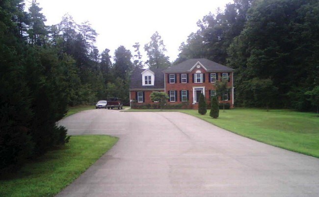
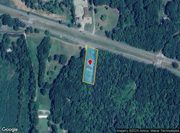
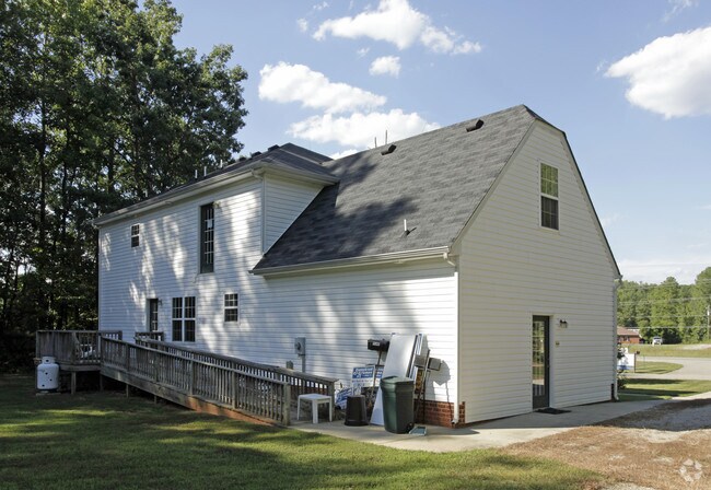
Property Record
2927 Anderson Hwy, Powhatan, VA 23139
NEARBY LISTINGS FOR SALE OR LEASE
Property Detail
2927 Anderson Hwy
040-38A
ROUTE 60
Multipleuses
Powhatan
X
Virginia
51145C0150C
38a
2025
1 AC
2025
Powhatan
500202
Richmond VA
2,778 SF
Richmond, VA
DEMOGRAPHICS near 2927 Anderson Hwy
1 Mile
3 Mile
5 Mile
2024 Total Population
727
6,513
15,126
2029 Population
792
7,109
16,578
Pop Growth 2024-2029
+ 8.94%
+ 9.15%
+ 9.60%
Average Age
42
42
42
2024 Total Households
274
2,443
5,629
HH Growth 2024-2029
+ 9.12%
+ 9.46%
+ 9.91%
Median Household Inc
$97,135
$100,682
$106,776
Avg Household Size
2.60
2.60
2.70
2024 Avg HH Vehicles
3.00
3.00
3.00
Median Home Value
$305,833
$321,271
$342,293
Median Year Built
1987
1989
1992
Nearby Places
Map Layers
Map Styles
 Street
 Aerial
- Restaurants
- Banks
- Shops
- Fitness
- Groceries
PUBLIC TRANSPORTATION
AIRPORT
Richmond International
DRIVE
WALK
Distance
Richmond International
55 min
36.6 mi
Freight Ports
Virginia Port Authority - Richmond
DRIVE
WALK
Distance
Virginia Port Authority - Richmond
45 min
26.7 mi
Nearby Properties
Address
Land Use
TOTAL SIZE
Lot Size
Zoning
Address
Land Use
TOTAL SIZE
Lot Size
Zoning
291,788 SF
61.70 AC
A-10
Address
Land Use
TOTAL SIZE
Lot Size
Zoning
51,431 SF
7.31 AC
CC
Address
Land Use
TOTAL SIZE
Lot Size
Zoning
40.15 AC
A-10
Address
Land Use
TOTAL SIZE
Lot Size
Zoning
2,309 SF
10.79 AC
A-10
Address
Land Use
TOTAL SIZE
Lot Size
Zoning
19,045 SF
2.60 AC
CC
Address
Land Use
TOTAL SIZE
Lot Size
Zoning
21,914 SF
6.95 AC
CC
Address
Land Use
TOTAL SIZE
Lot Size
Zoning
55,489 SF
10.09 AC
CC
Address
Land Use
TOTAL SIZE
Lot Size
Zoning
12,817 SF
4 AC
A-10
Address
Land Use
TOTAL SIZE
Lot Size
Zoning
17,740 SF
2.95 AC
A-10
Address
Land Use
TOTAL SIZE
Lot Size
Zoning
10,890 SF
14.22 AC
A-10
Address
Land Use
TOTAL SIZE
Lot Size
Zoning
5,331 SF
2 AC
CC
Address
Land Use
TOTAL SIZE
Lot Size
Zoning
2,805 SF
5.42 AC
CC
Address
Land Use
TOTAL SIZE
Lot Size
Zoning
12,125 SF
2.19 AC
CC
Address
Land Use
TOTAL SIZE
Lot Size
Zoning
9,710 SF
1.68 AC
CC
Address
Land Use
TOTAL SIZE
Lot Size
Zoning
11,121 SF
6.22 AC
CC
Address
Land Use
TOTAL SIZE
Lot Size
Zoning
14,640 SF
19.37 AC
I-1
Address
Land Use
TOTAL SIZE
Lot Size
Zoning
3,989 SF
2.16 AC
CC
Address
Land Use
TOTAL SIZE
Lot Size
Zoning
7,295 SF
1.24 AC
CC
Address
Land Use
TOTAL SIZE
Lot Size
Zoning
2,112 SF
324.72 AC
A-10
Address
Land Use
TOTAL SIZE
Lot Size
Zoning
1,680 SF
6.48 AC
CC
Address
Land Use
TOTAL SIZE
Lot Size
Zoning
3,047 SF
16.51 AC
CC
Address
Land Use
TOTAL SIZE
Lot Size
Zoning
14,750 SF
2.64 AC
CC
Address
Land Use
TOTAL SIZE
Lot Size
Zoning
315.84 AC
A-10
Address
Land Use
TOTAL SIZE
Lot Size
Zoning
12,552 SF
3 AC
CC
Address
Land Use
TOTAL SIZE
Lot Size
Zoning
6,056 SF
1.19 AC
CC
Address
Land Use
TOTAL SIZE
Lot Size
Zoning
1,084 SF
3.50 AC
CC
Address
Land Use
TOTAL SIZE
Lot Size
Zoning
19,150 SF
1.91 AC
CC
Address
Land Use
TOTAL SIZE
Lot Size
Zoning
6,120 SF
9.54 AC
R-2
Address
Land Use
TOTAL SIZE
Lot Size
Zoning
3,883 SF
2.50 AC
CC
The World's #1 Commercial Real Estate Marketplace
Connect with us
© 2026 CoStar Group
The information above has been obtained from sources believed reliable. While we do not doubt its accuracy we have not verified it and make no guarantee, warranty or representation about it. It is your responsibility to independently confirm its accuracy and completeness. Any projections, opinions, assumptions, or estimates used are for example only and do not represent the current or future performance of the property. The value of this transaction to you depends on tax and other factors which should be evaluated by your tax, financial, and legal advisors. You and your advisors should conduct a careful, independent investigation of the property to determine to your satisfaction the suitability of the property for your needs.