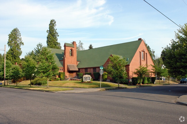
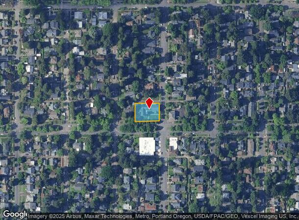
Property Record
2927 Ne Ainsworth St, Portland, OR 97211
NEARBY LISTINGS FOR SALE OR LEASE
Property Detail
2927 Ne Ainsworth St
Portland-Vancouver-Hillsboro, OR-WA
Irvington Pk
R190284
IRVINGTON PK, BLOCK 36, LOT 3-8 TL 10700
Commercialnec
Multnomah
ARE
Oregon
41067C0400E
3-8
0
0.31 AC
2025
NE Close-In
003602
Portland
8,320 SF
DEMOGRAPHICS near 2927 Ne Ainsworth St
1 mile
3 mile
5 mile
2024 Total Population
19,991
138,981
374,158
2029 Population
19,436
136,506
372,270
Pop Growth 2024-2029
(2.78%)
(1.78%)
(0.50%)
Average Age
39
40
40
2024 Total Households
8,076
60,854
175,898
HH Growth 2024-2029
(3.15%)
(1.92%)
(0.47%)
Median Household Inc
$105,223
$93,018
$79,735
Avg Household Size
2.30
2.20
2.00
2024 Avg HH Vehicles
2.00
2.00
1.00
Median Home Value
$663,574
$646,287
$600,402
Median Year Built
1947
1948
1960
Nearby Places
Map Layers
Map Styles
 Street
 Aerial
Transit
 Traffic
 Biking
Places
Listings with unknown addresses are not visible on the map
- Restaurants
- Banks
- Shops
- Fitness
- Groceries
PUBLIC TRANSPORTATION
COMMUTER RAIL
Drive
Walk
Distance
14 min
4.6 mi
Drive
Walk
Distance
17 min
7.3 mi
AIRPORT
Portland International
Drive
Walk
Distance
Portland International
14 min
5.4 mi
Freight Ports
Port of Portland
Drive
Walk
Distance
Port of Portland
15 min
5.7 mi
Nearby Properties
Address
Land Use
TOTAL SIZE
Lot Size
Zoning
Address
Land Use
TOTAL SIZE
Lot Size
Zoning
1,405,000 SF
16.51 AC
IG2
Address
Land Use
TOTAL SIZE
Lot Size
Zoning
395,815 SF
2.66 AC
IRD
Address
Land Use
TOTAL SIZE
Lot Size
Zoning
627,500 SF
16.60 AC
CX
Address
Land Use
TOTAL SIZE
Lot Size
Zoning
15,473 SF
192.67 AC
IG2
Address
Land Use
TOTAL SIZE
Lot Size
Zoning
417,324 SF
0.68 AC
CX
Address
Land Use
TOTAL SIZE
Lot Size
Zoning
257,700 SF
2.89 AC
EX
Address
Land Use
TOTAL SIZE
Lot Size
Zoning
178,785 SF
10.20 AC
R5
Address
Land Use
TOTAL SIZE
Lot Size
Zoning
817,845 SF
22.54 AC
IG2
Address
Land Use
TOTAL SIZE
Lot Size
Zoning
7.78 AC
EX
Address
Land Use
TOTAL SIZE
Lot Size
Zoning
Address
Land Use
TOTAL SIZE
Lot Size
Zoning
243,371 SF
0.67 AC
CI2
Address
Land Use
TOTAL SIZE
Lot Size
Zoning
645,294 SF
5.64 AC
CO2D
Address
Land Use
TOTAL SIZE
Lot Size
Zoning
247,520 SF
7.74 AC
CX
Address
Land Use
TOTAL SIZE
Lot Size
Zoning
193,898 SF
2.50 AC
IRD
Address
Land Use
TOTAL SIZE
Lot Size
Zoning
134,398 SF
3.17 AC
CG
Address
Land Use
TOTAL SIZE
Lot Size
Zoning
23.95 AC
IG2
Address
Land Use
TOTAL SIZE
Lot Size
Zoning
126.43 AC
IG2
Address
Land Use
TOTAL SIZE
Lot Size
Zoning
1,660,710 SF
110.33 AC
IG2
Address
Land Use
TOTAL SIZE
Lot Size
Zoning
2,218,439 SF
21.88 AC
CX
Address
Land Use
TOTAL SIZE
Lot Size
Zoning
105.72 AC
IG2
Address
Land Use
TOTAL SIZE
Lot Size
Zoning
85,000 SF
1.65 AC
CI2
Address
Land Use
TOTAL SIZE
Lot Size
Zoning
97,000 SF
NULL
Address
Land Use
TOTAL SIZE
Lot Size
Zoning
107,958 SF
2.48 AC
IG2
Address
Land Use
TOTAL SIZE
Lot Size
Zoning
40,595 SF
1.99 AC
IRD
Address
Land Use
TOTAL SIZE
Lot Size
Zoning
96,554 SF
2.02 AC
CM3
Address
Land Use
TOTAL SIZE
Lot Size
Zoning
320,732 SF
1.14 AC
CX
Address
Land Use
TOTAL SIZE
Lot Size
Zoning
440,000 SF
1.80 AC
CX
Address
Land Use
TOTAL SIZE
Lot Size
Zoning
11,375 SF
1.46 AC
CI2
Address
Land Use
TOTAL SIZE
Lot Size
Zoning
785,000 SF
4 AC
NULL
Address
Land Use
TOTAL SIZE
Lot Size
Zoning
133.11 AC
IG2
The World's #1 Commercial Real Estate Marketplace
Connect with us
© 2026 CoStar Group
The information above has been obtained from sources believed reliable. While we do not doubt its accuracy we have not verified it and make no guarantee, warranty or representation about it. It is your responsibility to independently confirm its accuracy and completeness. Any projections, opinions, assumptions, or estimates used are for example only and do not represent the current or future performance of the property. The value of this transaction to you depends on tax and other factors which should be evaluated by your tax, financial, and legal advisors. You and your advisors should conduct a careful, independent investigation of the property to determine to your satisfaction the suitability of the property for your needs.