Property Record
2928 State Highway 16 S, Graham, TX 76450
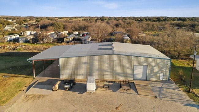
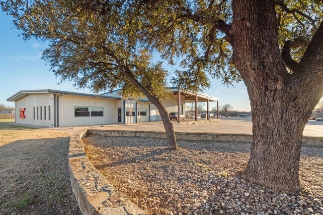
Property Detail
2928 State Highway 16 S
784285
BUNGER HWY - TR 22A - LOT 1,11,12 - A-0144
Commercialnec
YOUNG
B and X Area of moderate flood hazard, usually the area between the limits of the 100-year and 500-year floods.
Texas
2025
1,11
2025
1.02 AC
950402
Texas North Area
2,528 SF
Other Market Areas
NEARBY LISTINGS FOR SALE OR LEASE
DEMOGRAPHICS near 2928 State Highway 16 S
1 mile
3 mile
5 mile
2025 Total Population
1,051
8,568
10,744
2030 Population
1,052
8,726
10,922
Pop Growth 2025-2030
+ 0.10%
+ 1.84%
+ 1.66%
Average Age
44
41
41
2025 Total Households
443
3,401
4,265
HH Growth 2025-2030
+ 0.45%
+ 1.97%
+ 1.81%
Median Household Inc
$105,921
$66,140
$65,343
Avg Household Size
2.30
2.50
2.50
2025 Avg HH Vehicles
2.00
2.00
2.00
Median Home Value
$207,895
$181,003
$184,619
Median Year Built
1987
1977
1976
Nearby Places
Map Layers
Map Styles
 Street
 Aerial
Layers
 Traffic
 Biking
Places
Listings with unknown addresses are not visible on the map
- Restaurants
- Banks
- Shops
- Fitness
- Groceries
SALE & LEASE HISTORY
LISTING DATE
SALE/LEASE

Mar 20, 2025
For Sale
Nearby Properties
Address
Land Use
TOTAL SIZE
Lot Size
Zoning
Address
Land Use
TOTAL SIZE
Lot Size
Zoning
50,700 SF
22.38 AC
Address
Land Use
TOTAL SIZE
Lot Size
Zoning
562,428 SF
31.37 AC
Address
Land Use
TOTAL SIZE
Lot Size
Zoning
54,666 SF
5.34 AC
Address
Land Use
TOTAL SIZE
Lot Size
Zoning
100,000 SF
6.56 AC
Address
Land Use
TOTAL SIZE
Lot Size
Zoning
42,278 SF
Address
Land Use
TOTAL SIZE
Lot Size
Zoning
51,574 SF
3.08 AC
Address
Land Use
TOTAL SIZE
Lot Size
Zoning
32,443 SF
0.59 AC
Address
Land Use
TOTAL SIZE
Lot Size
Zoning
26,667 SF
0.43 AC
Address
Land Use
TOTAL SIZE
Lot Size
Zoning
29,833 SF
0.75 AC
Address
Land Use
TOTAL SIZE
Lot Size
Zoning
40,170 SF
3.35 AC
Address
Land Use
TOTAL SIZE
Lot Size
Zoning
26,024 SF
0.52 AC
Address
Land Use
TOTAL SIZE
Lot Size
Zoning
25,232 SF
3.72 AC
Address
Land Use
TOTAL SIZE
Lot Size
Zoning
10,040 SF
3.08 AC
Address
Land Use
TOTAL SIZE
Lot Size
Zoning
118,358 SF
18.50 AC
Address
Land Use
TOTAL SIZE
Lot Size
Zoning
666.18 AC
Address
Land Use
TOTAL SIZE
Lot Size
Zoning
91,941 SF
3 AC
Address
Land Use
TOTAL SIZE
Lot Size
Zoning
19,808 SF
2.15 AC
Address
Land Use
TOTAL SIZE
Lot Size
Zoning
128,972 SF
2.32 AC
Address
Land Use
TOTAL SIZE
Lot Size
Zoning
548.70 AC
Address
Land Use
TOTAL SIZE
Lot Size
Zoning
16,215 SF
1.38 AC
Address
Land Use
TOTAL SIZE
Lot Size
Zoning
18,960 SF
1.84 AC
Address
Land Use
TOTAL SIZE
Lot Size
Zoning
38,134 SF
1.03 AC
Address
Land Use
TOTAL SIZE
Lot Size
Zoning
5,120 SF
2.59 AC
Address
Land Use
TOTAL SIZE
Lot Size
Zoning
14,620 SF
1.34 AC
Address
Land Use
TOTAL SIZE
Lot Size
Zoning
15,846 SF
9.50 AC
Address
Land Use
TOTAL SIZE
Lot Size
Zoning
1,353.99 AC
Address
Land Use
TOTAL SIZE
Lot Size
Zoning
11,019 SF
1,353.99 AC
Address
Land Use
TOTAL SIZE
Lot Size
Zoning
32,690 SF
2.61 AC
Address
Land Use
TOTAL SIZE
Lot Size
Zoning
20,201 SF
3.75 AC
Address
Land Use
TOTAL SIZE
Lot Size
Zoning
16,800 SF
3.50 AC
The World's #1 Commercial Real Estate Marketplace
Connect with us
© 2026 CoStar Group
The information above has been obtained from sources believed reliable. While we do not doubt its accuracy we have not verified it and make no guarantee, warranty or representation about it. It is your responsibility to independently confirm its accuracy and completeness. Any projections, opinions, assumptions, or estimates used are for example only and do not represent the current or future performance of the property. The value of this transaction to you depends on tax and other factors which should be evaluated by your tax, financial, and legal advisors. You and your advisors should conduct a careful, independent investigation of the property to determine to your satisfaction the suitability of the property for your needs.