Property Record
2929 Baird Rd, Shreveport, LA 71118
NEARBY LISTINGS FOR SALE OR LEASE
Property Detail
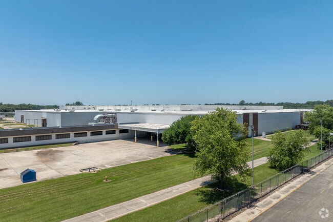
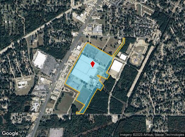
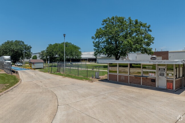
2929 Baird Rd
Shreveport/Bossier City
9595 Mansfield Industrial Subd
Shreveport-Bossier City, LA
74.577 ACS. M/L LOT 1, 9595 MANSFIELD INDUSTRIAL SUBDIVISION, 161409-086-0001
161409-086-0001-00
Caddo
Miscellaneous
Louisiana
2024
1,9595
2024
74.58 AC
024108
Caddo Parish
854,086 SF
DEMOGRAPHICS near 2929 Baird Rd
1 Mile
3 Mile
5 Mile
2024 Total Population
4,884
26,764
62,686
2029 Population
4,577
25,185
59,626
Pop Growth 2024-2029
(6.29%)
(5.90%)
(4.88%)
Average Age
41
40
39
2024 Total Households
1,958
10,789
25,121
HH Growth 2024-2029
(6.54%)
(6.00%)
(4.95%)
Median Household Inc
$58,183
$51,093
$42,437
Avg Household Size
2.30
2.40
2.40
2024 Avg HH Vehicles
2.00
2.00
2.00
Median Home Value
$161,782
$159,355
$146,768
Median Year Built
1975
1977
1976
Nearby Places
Map Layers
Map Styles
 Street
 Aerial
- Restaurants
- Banks
- Shops
- Fitness
- Groceries
PUBLIC TRANSPORTATION
AIRPORT
Shreveport Regional
DRIVE
WALK
Distance
Shreveport Regional
17 min
5.6 mi
Freight Ports
Port of Shreveport
DRIVE
WALK
Distance
Port of Shreveport
23 min
13.0 mi
SALE & LEASE HISTORY
LISTING DATE
SALE/LEASE

Sep 25, 2016
For Lease
Sep 23, 2016
For Sale
Mar 30, 2022
For Sale
Mar 09, 2020
For Lease
Jan 05, 2024
For Lease
Feb 08, 2021
For Lease
Apr 10, 2024
For Sale
Nearby Properties
Address
Land Use
TOTAL SIZE
Lot Size
Zoning
Address
Land Use
TOTAL SIZE
Lot Size
Zoning
444,895 SF
16.46 AC
Address
Land Use
TOTAL SIZE
Lot Size
Zoning
347,506 SF
59.03 AC
Address
Land Use
TOTAL SIZE
Lot Size
Zoning
310,852 SF
19.77 AC
Address
Land Use
TOTAL SIZE
Lot Size
Zoning
258,750 SF
26.89 AC
Address
Land Use
TOTAL SIZE
Lot Size
Zoning
71,819 SF
6 AC
Address
Land Use
TOTAL SIZE
Lot Size
Zoning
100,000 SF
15.25 AC
Address
Land Use
TOTAL SIZE
Lot Size
Zoning
212,938 SF
23.11 AC
Address
Land Use
TOTAL SIZE
Lot Size
Zoning
533,383 SF
62.46 AC
Address
Land Use
TOTAL SIZE
Lot Size
Zoning
185,375 SF
10.27 AC
Address
Land Use
TOTAL SIZE
Lot Size
Zoning
74,772 SF
0.43 AC
Address
Land Use
TOTAL SIZE
Lot Size
Zoning
47,486 SF
1.59 AC
Address
Land Use
TOTAL SIZE
Lot Size
Zoning
57,854 SF
4.13 AC
Address
Land Use
TOTAL SIZE
Lot Size
Zoning
42,577 SF
6.67 AC
Address
Land Use
TOTAL SIZE
Lot Size
Zoning
248,404 SF
16.91 AC
Address
Land Use
TOTAL SIZE
Lot Size
Zoning
74,195 SF
4.71 AC
Address
Land Use
TOTAL SIZE
Lot Size
Zoning
37,500 SF
5.99 AC
Address
Land Use
TOTAL SIZE
Lot Size
Zoning
46,557 SF
15.10 AC
Address
Land Use
TOTAL SIZE
Lot Size
Zoning
48,423 SF
6.43 AC
Address
Land Use
TOTAL SIZE
Lot Size
Zoning
40,363 SF
9.40 AC
Address
Land Use
TOTAL SIZE
Lot Size
Zoning
34,000 SF
4.62 AC
Address
Land Use
TOTAL SIZE
Lot Size
Zoning
92,770 SF
5.70 AC
Address
Land Use
TOTAL SIZE
Lot Size
Zoning
47,239 SF
5.62 AC
Address
Land Use
TOTAL SIZE
Lot Size
Zoning
207,214 SF
13.24 AC
Address
Land Use
TOTAL SIZE
Lot Size
Zoning
121,139 SF
Address
Land Use
TOTAL SIZE
Lot Size
Zoning
47,433 SF
3.65 AC
Address
Land Use
TOTAL SIZE
Lot Size
Zoning
64,263 SF
10.75 AC
Address
Land Use
TOTAL SIZE
Lot Size
Zoning
70,886 SF
6.20 AC
Address
Land Use
TOTAL SIZE
Lot Size
Zoning
78,822 SF
2.45 AC
Address
Land Use
TOTAL SIZE
Lot Size
Zoning
93,680 SF
12 AC
The World's #1 Commercial Real Estate Marketplace
Connect with us
© 2025 CoStar Group
The information above has been obtained from sources believed reliable. While we do not doubt its accuracy we have not verified it and make no guarantee, warranty or representation about it. It is your responsibility to independently confirm its accuracy and completeness. Any projections, opinions, assumptions, or estimates used are for example only and do not represent the current or future performance of the property. The value of this transaction to you depends on tax and other factors which should be evaluated by your tax, financial, and legal advisors. You and your advisors should conduct a careful, independent investigation of the property to determine to your satisfaction the suitability of the property for your needs.