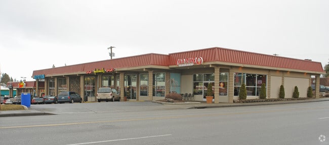
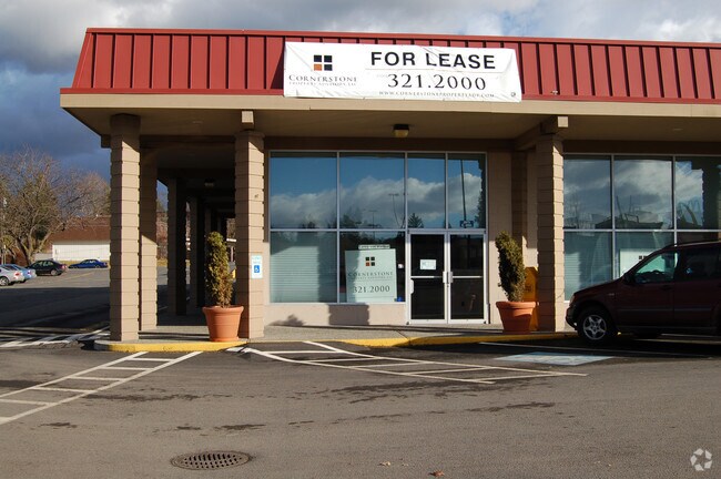
Property Record
2929 E 29Th Ave, Spokane, WA 99223


NEARBY LISTINGS FOR SALE OR LEASE
Property Detail
2929 E 29Th Ave
35273.0060
27-25-43 PTN OF SW1/4 OF SW1/4 DAF: BEG AT SW COR OF SEC, TH E ALG SLY LN OF SEC 267.FT, TH N 00DEG 30MIN 55SDS E 30FT TO NLY R/W LN OF 29TH AVE, TH E ALG NLY R/W 115FT TO POB, TH N00DEG 31MIN 00SDS E 207.06FT, TH S89DEG 55MIN 50SDS E 176.84FT, TH S0
Storebuilding
Spokane
X
Washington
53063C0563D
0.65 AC
2025
South Hill
2025
Spokane
004601
Spokane-Spokane Valley, WA
10,818 SF
DEMOGRAPHICS near 2929 E 29Th Ave
1 Mile
3 Mile
5 Mile
2024 Total Population
15,990
84,168
182,158
2029 Population
17,061
89,779
194,134
Pop Growth 2024-2029
+ 6.70%
+ 6.67%
+ 6.57%
Average Age
43
41
40
2024 Total Households
6,724
35,129
76,229
HH Growth 2024-2029
+ 6.98%
+ 6.91%
+ 6.90%
Median Household Inc
$72,104
$71,479
$60,849
Avg Household Size
2.20
2.30
2.20
2024 Avg HH Vehicles
2.00
2.00
2.00
Median Home Value
$363,303
$396,902
$346,153
Median Year Built
1978
1974
1969
Nearby Places
Map Layers
Map Styles
 Street
 Aerial
- Restaurants
- Banks
- Shops
- Fitness
- Groceries
PUBLIC TRANSPORTATION
COMMUTER RAIL
DRIVE
WALK
Distance
11 min
4.0 mi
AIRPORT
Spokane International
DRIVE
WALK
Distance
Spokane International
20 min
11.0 mi
Nearby Properties
Address
Land Use
TOTAL SIZE
Lot Size
Zoning
Address
Land Use
TOTAL SIZE
Lot Size
Zoning
763,627 SF
12.44 AC
OR
Address
Land Use
TOTAL SIZE
Lot Size
Zoning
481,348 SF
17.09 AC
DTU
Address
Land Use
TOTAL SIZE
Lot Size
Zoning
226,702 SF
49.25 AC
RSF
Address
Land Use
TOTAL SIZE
Lot Size
Zoning
365,804 SF
16.13 AC
RSF
Address
Land Use
TOTAL SIZE
Lot Size
Zoning
251,542 SF
5.78 AC
DTG
Address
Land Use
TOTAL SIZE
Lot Size
Zoning
270,262 SF
29.10 AC
Address
Land Use
TOTAL SIZE
Lot Size
Zoning
218,684 SF
13.29 AC
RMF
Address
Land Use
TOTAL SIZE
Lot Size
Zoning
124,234 SF
13.54 AC
RSF
Address
Land Use
TOTAL SIZE
Lot Size
Zoning
210,277 SF
19.18 AC
RMF
Address
Land Use
TOTAL SIZE
Lot Size
Zoning
137,503 SF
17.31 AC
GC
Address
Land Use
TOTAL SIZE
Lot Size
Zoning
107,240 SF
1.54 AC
CC1
Address
Land Use
TOTAL SIZE
Lot Size
Zoning
289,573 SF
7.73 AC
RMF
Address
Land Use
TOTAL SIZE
Lot Size
Zoning
91,310 SF
2.34 AC
Address
Land Use
TOTAL SIZE
Lot Size
Zoning
135,715 SF
4.73 AC
RMF
Address
Land Use
TOTAL SIZE
Lot Size
Zoning
108,237 SF
3.48 AC
LI
Address
Land Use
TOTAL SIZE
Lot Size
Zoning
58,522 SF
19.91 AC
HI
Address
Land Use
TOTAL SIZE
Lot Size
Zoning
91,048 SF
3.81 AC
OR
Address
Land Use
TOTAL SIZE
Lot Size
Zoning
119,933 SF
5.61 AC
Address
Land Use
TOTAL SIZE
Lot Size
Zoning
138,840 SF
2.79 AC
DTU
Address
Land Use
TOTAL SIZE
Lot Size
Zoning
159,720 SF
6.84 AC
RMF
Address
Land Use
TOTAL SIZE
Lot Size
Zoning
155,133 SF
3.76 AC
RHD
Address
Land Use
TOTAL SIZE
Lot Size
Zoning
41,890 SF
2.11 AC
OR
Address
Land Use
TOTAL SIZE
Lot Size
Zoning
66,193 SF
1.99 AC
OR
Address
Land Use
TOTAL SIZE
Lot Size
Zoning
77,694 SF
4.63 AC
RHD
Address
Land Use
TOTAL SIZE
Lot Size
Zoning
78,990 SF
5.58 AC
RSF
Address
Land Use
TOTAL SIZE
Lot Size
Zoning
79,200 SF
OR
Address
Land Use
TOTAL SIZE
Lot Size
Zoning
173,714 SF
9.98 AC
HDR
Address
Land Use
TOTAL SIZE
Lot Size
Zoning
119,910 SF
3.66 AC
OR
Address
Land Use
TOTAL SIZE
Lot Size
Zoning
142,500 SF
6.86 AC
RMF
Address
Land Use
TOTAL SIZE
Lot Size
Zoning
81,833 SF
3.97 AC
OR
The World's #1 Commercial Real Estate Marketplace
Connect with us
© 2026 CoStar Group
The information above has been obtained from sources believed reliable. While we do not doubt its accuracy we have not verified it and make no guarantee, warranty or representation about it. It is your responsibility to independently confirm its accuracy and completeness. Any projections, opinions, assumptions, or estimates used are for example only and do not represent the current or future performance of the property. The value of this transaction to you depends on tax and other factors which should be evaluated by your tax, financial, and legal advisors. You and your advisors should conduct a careful, independent investigation of the property to determine to your satisfaction the suitability of the property for your needs.