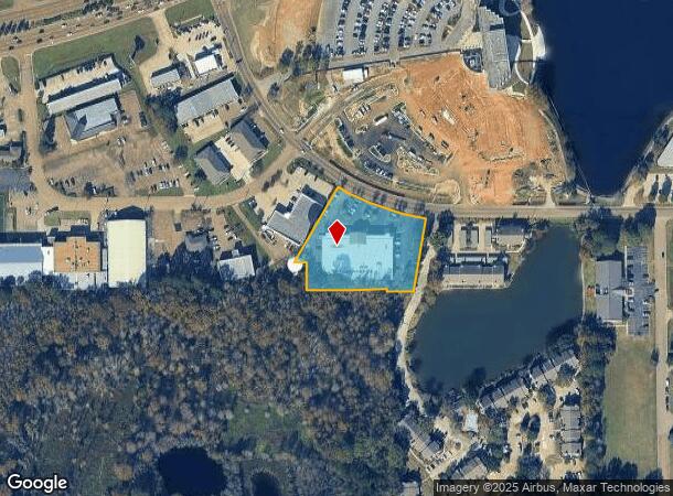
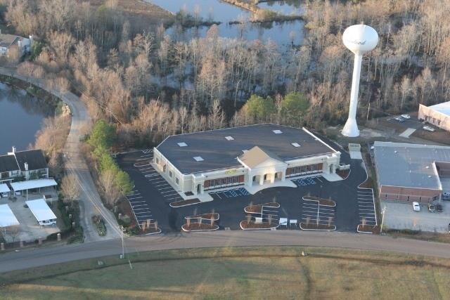
Property Record
2929 Layfair Dr, Flowood, MS 39232

NEARBY LISTINGS FOR SALE OR LEASE
Property Detail
2929 Layfair Dr
Jackson, MS
Mirror Lake Sub
E10L-000003-01070
LOTS 107 & 108 MIRROR LAKE SUB DB 608 PG 0314 0100590
Professionalbldglegalinsurancerealestateetc
Rankin
AE
Mississippi
28121C0178G
107
2024
1.96 AC
2024
Brandon/Flowood/Pearl
020304
Jackson
26,393 SF
DEMOGRAPHICS near 2929 Layfair Dr
1 Mile
3 Mile
5 Mile
2024 Total Population
1,266
15,603
85,350
2029 Population
1,288
15,377
83,567
Pop Growth 2024-2029
+ 1.74%
(1.45%)
(2.09%)
Average Age
35
39
39
2024 Total Households
778
6,691
37,304
HH Growth 2024-2029
+ 1.80%
(1.39%)
(2.32%)
Median Household Inc
$42,500
$67,156
$50,451
Avg Household Size
1.60
2.20
2.20
2024 Avg HH Vehicles
2.00
2.00
2.00
Median Home Value
$138,461
$211,909
$167,626
Median Year Built
1987
1976
1975
Nearby Places
Map Layers
Map Styles
 Street
 Aerial
- Restaurants
- Banks
- Shops
- Fitness
- Groceries
PUBLIC TRANSPORTATION
COMMUTER RAIL
Jackson (City of New Orleans - Amtrak)
DRIVE
WALK
Distance
Jackson (City of New Orleans - Amtrak)
10 min
6.8 mi
AIRPORT
Jackson-Medgar Wiley Evers International
DRIVE
WALK
Distance
Jackson-Medgar Wiley Evers International
14 min
6.8 mi
Freight Ports
Port of Greater Baton Rouge
DRIVE
WALK
Distance
Port of Greater Baton Rouge
204 min
183.1 mi
SALE & LEASE HISTORY
LISTING DATE
SALE/LEASE

May 08, 2018
For Sale
Jun 04, 2020
For Lease
Jul 14, 2017
For Lease
Jan 15, 2021
For Sale
Nearby Properties
Address
Land Use
TOTAL SIZE
Lot Size
Zoning
Address
Land Use
TOTAL SIZE
Lot Size
Zoning
14,236 SF
7.38 AC
Address
Land Use
TOTAL SIZE
Lot Size
Zoning
48,134 SF
6.62 AC
Address
Land Use
TOTAL SIZE
Lot Size
Zoning
117,983 SF
7.01 AC
Address
Land Use
TOTAL SIZE
Lot Size
Zoning
19,639 SF
4.07 AC
Address
Land Use
TOTAL SIZE
Lot Size
Zoning
236.80 AC
Address
Land Use
TOTAL SIZE
Lot Size
Zoning
33,960 SF
19,602 AC
Address
Land Use
TOTAL SIZE
Lot Size
Zoning
136,355 SF
26.65 AC
Address
Land Use
TOTAL SIZE
Lot Size
Zoning
121,590 SF
Address
Land Use
TOTAL SIZE
Lot Size
Zoning
6,639 SF
35.63 AC
Address
Land Use
TOTAL SIZE
Lot Size
Zoning
125,008 SF
18 AC
Address
Land Use
TOTAL SIZE
Lot Size
Zoning
30,925 SF
38.73 AC
Address
Land Use
TOTAL SIZE
Lot Size
Zoning
59,840 SF
2.72 AC
Address
Land Use
TOTAL SIZE
Lot Size
Zoning
64,949 SF
3 AC
Address
Land Use
TOTAL SIZE
Lot Size
Zoning
81,649 SF
5.60 AC
Address
Land Use
TOTAL SIZE
Lot Size
Zoning
1,787 SF
16.82 AC
Address
Land Use
TOTAL SIZE
Lot Size
Zoning
40.72 AC
Address
Land Use
TOTAL SIZE
Lot Size
Zoning
74,153 SF
4.52 AC
Address
Land Use
TOTAL SIZE
Lot Size
Zoning
5,354 SF
0.68 AC
Address
Land Use
TOTAL SIZE
Lot Size
Zoning
66,102 SF
6.21 AC
Address
Land Use
TOTAL SIZE
Lot Size
Zoning
15,115 SF
2.48 AC
Address
Land Use
TOTAL SIZE
Lot Size
Zoning
230,401 SF
643,381.54 AC
Address
Land Use
TOTAL SIZE
Lot Size
Zoning
90,610 SF
Address
Land Use
TOTAL SIZE
Lot Size
Zoning
15,645 SF
1.10 AC
Address
Land Use
TOTAL SIZE
Lot Size
Zoning
2,457 SF
11.42 AC
Address
Land Use
TOTAL SIZE
Lot Size
Zoning
23,589 SF
110,808.08 AC
Address
Land Use
TOTAL SIZE
Lot Size
Zoning
11,578 SF
0.89 AC
Address
Land Use
TOTAL SIZE
Lot Size
Zoning
73,795 SF
5.02 AC
Address
Land Use
TOTAL SIZE
Lot Size
Zoning
52,343 SF
3.39 AC
The World's #1 Commercial Real Estate Marketplace
Connect with us
© 2025 CoStar Group
The information above has been obtained from sources believed reliable. While we do not doubt its accuracy we have not verified it and make no guarantee, warranty or representation about it. It is your responsibility to independently confirm its accuracy and completeness. Any projections, opinions, assumptions, or estimates used are for example only and do not represent the current or future performance of the property. The value of this transaction to you depends on tax and other factors which should be evaluated by your tax, financial, and legal advisors. You and your advisors should conduct a careful, independent investigation of the property to determine to your satisfaction the suitability of the property for your needs.