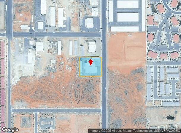
Property Record
293 N 2260 W, Hurricane, UT 84737
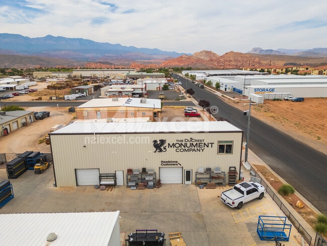

This Property Is For Sale
NEARBY LISTINGS FOR SALE OR LEASE
-
-
View all Hurricane listings for sale on LoopNet.com
Property Detail
293 N 2260 W
St. George, UT
Hurricane Industrial Park
0265861
SUBDIVISION: HURRICANE INDUSTRIAL PARK (H) LOT: 26
Commercialnec
Washington
X
Utah
49053C0840G
26
2024
1.06 AC
2025
Cedar City & St George
270904
Other Market Areas
15,000 SF
DEMOGRAPHICS near 293 N 2260 W
1 mile
3 mile
5 mile
2024 Total Population
4,118
15,910
28,248
2029 Population
4,505
17,259
30,737
Pop Growth 2024-2029
+ 9.40%
+ 8.48%
+ 8.81%
Average Age
45
41
41
2024 Total Households
1,638
5,542
9,789
HH Growth 2024-2029
+ 9.52%
+ 8.82%
+ 9.06%
Median Household Inc
$73,230
$71,660
$73,722
Avg Household Size
2.50
2.80
2.80
2024 Avg HH Vehicles
2.00
2.00
2.00
Median Home Value
$521,815
$460,375
$464,716
Median Year Built
2008
2003
2001
Nearby Places
Map Layers
Map Styles
 Street
 Aerial
Transit
 Traffic
 Biking
Places
Listings with unknown addresses are not visible on the map
- Restaurants
- Banks
- Shops
- Fitness
- Groceries
PUBLIC TRANSPORTATION
AIRPORT
St George Regional
Drive
Walk
Distance
St George Regional
27 min
18.4 mi
Freight Ports
Port of Long Beach
Drive
Walk
Distance
Port of Long Beach
459 min
417.6 mi
Nearby Properties
Address
Land Use
TOTAL SIZE
Lot Size
Zoning
Address
Land Use
TOTAL SIZE
Lot Size
Zoning
500.58 AC
Address
Land Use
TOTAL SIZE
Lot Size
Zoning
163,468 SF
19.73 AC
HC
Address
Land Use
TOTAL SIZE
Lot Size
Zoning
48,529 SF
26.71 AC
M1
Address
Land Use
TOTAL SIZE
Lot Size
Zoning
93,494 SF
23.97 AC
PF
Address
Land Use
TOTAL SIZE
Lot Size
Zoning
55,676 SF
8.90 AC
PF
Address
Land Use
TOTAL SIZE
Lot Size
Zoning
57,202 SF
2.50 AC
Address
Land Use
TOTAL SIZE
Lot Size
Zoning
48,863 SF
1.72 AC
HC
Address
Land Use
TOTAL SIZE
Lot Size
Zoning
38,940 SF
1.03 AC
Address
Land Use
TOTAL SIZE
Lot Size
Zoning
1,155 SF
68.88 AC
APO
Address
Land Use
TOTAL SIZE
Lot Size
Zoning
20,139 SF
6.46 AC
HC
Address
Land Use
TOTAL SIZE
Lot Size
Zoning
30,643 SF
26.13 AC
PDO
Address
Land Use
TOTAL SIZE
Lot Size
Zoning
7,254 SF
6.15 AC
HC
Address
Land Use
TOTAL SIZE
Lot Size
Zoning
134,714 SF
14.80 AC
M-1
Address
Land Use
TOTAL SIZE
Lot Size
Zoning
64,510 SF
4.40 AC
PDO
Address
Land Use
TOTAL SIZE
Lot Size
Zoning
83,574 SF
4.04 AC
R110
Address
Land Use
TOTAL SIZE
Lot Size
Zoning
92,646 SF
5.06 AC
R110
Address
Land Use
TOTAL SIZE
Lot Size
Zoning
42,267 SF
3.09 AC
HC
Address
Land Use
TOTAL SIZE
Lot Size
Zoning
22,080 SF
6.82 AC
HC
Address
Land Use
TOTAL SIZE
Lot Size
Zoning
49,953 SF
1.83 AC
HC
Address
Land Use
TOTAL SIZE
Lot Size
Zoning
1,708 SF
47.04 AC
RA1
Address
Land Use
TOTAL SIZE
Lot Size
Zoning
30,519 SF
5.76 AC
HC
Address
Land Use
TOTAL SIZE
Lot Size
Zoning
22,576 SF
5.35 AC
Address
Land Use
TOTAL SIZE
Lot Size
Zoning
23,586 SF
3.52 AC
HC
Address
Land Use
TOTAL SIZE
Lot Size
Zoning
48,990 SF
24.69 AC
PF
The World's #1 Commercial Real Estate Marketplace
Connect with us
© 2026 CoStar Group
The information above has been obtained from sources believed reliable. While we do not doubt its accuracy we have not verified it and make no guarantee, warranty or representation about it. It is your responsibility to independently confirm its accuracy and completeness. Any projections, opinions, assumptions, or estimates used are for example only and do not represent the current or future performance of the property. The value of this transaction to you depends on tax and other factors which should be evaluated by your tax, financial, and legal advisors. You and your advisors should conduct a careful, independent investigation of the property to determine to your satisfaction the suitability of the property for your needs.