Property Record
293 Us Highway 321 Byp S, Winnsboro, SC 29180


NEARBY LISTINGS FOR SALE OR LEASE
Property Detail
293 Us Highway 321 Byp S
1250404005000
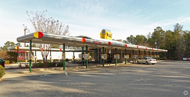
293 US HWY 321 BY PASS SONIC PLAT: 569 - 1489
Restaurantdrivein
Fairfield
X
South Carolina
45039C0351C
0.92 AC
2025
Fairfield County
2025
Columbia
960401
Columbia, SC
2,077 SF
DEMOGRAPHICS near 293 Us Highway 321 Byp S
1 Mile
3 Mile
5 Mile
2024 Total Population
2,414
6,550
7,797
2029 Population
2,349
6,367
7,573
Pop Growth 2024-2029
(2.69%)
(2.79%)
(2.87%)
Average Age
40
42
43
2024 Total Households
1,076
2,891
3,418
HH Growth 2024-2029
(2.32%)
(2.53%)
(2.60%)
Median Household Inc
$32,115
$33,177
$34,431
Avg Household Size
2.20
2.20
2.20
2024 Avg HH Vehicles
1.00
2.00
2.00
Median Home Value
$78,424
$94,203
$96,404
Median Year Built
1979
1978
1979
Nearby Places
Map Layers
Map Styles
 Street
 Aerial
- Restaurants
- Banks
- Shops
- Fitness
- Groceries
PUBLIC TRANSPORTATION
AIRPORT
Columbia Metro
DRIVE
WALK
Distance
Columbia Metro
61 min
42.8 mi
Nearby Properties
Address
Land Use
TOTAL SIZE
Lot Size
Zoning
Address
Land Use
TOTAL SIZE
Lot Size
Zoning
150.48 AC
I-1
Address
Land Use
TOTAL SIZE
Lot Size
Zoning
176,356 SF
15.23 AC
I-1
Address
Land Use
TOTAL SIZE
Lot Size
Zoning
59,472 SF
8 AC
B2
Address
Land Use
TOTAL SIZE
Lot Size
Zoning
421.71 AC
RD
Address
Land Use
TOTAL SIZE
Lot Size
Zoning
41,321 SF
8.01 AC
B2
Address
Land Use
TOTAL SIZE
Lot Size
Zoning
63,860 SF
10.39 AC
C2
Address
Land Use
TOTAL SIZE
Lot Size
Zoning
307,847 SF
38.43 AC
I-1
Address
Land Use
TOTAL SIZE
Lot Size
Zoning
12,664 SF
3 AC
B2
Address
Land Use
TOTAL SIZE
Lot Size
Zoning
9,984 SF
1.69 AC
C2
Address
Land Use
TOTAL SIZE
Lot Size
Zoning
25,496 SF
2.69 AC
C1
Address
Land Use
TOTAL SIZE
Lot Size
Zoning
16,554 SF
6 AC
C2
Address
Land Use
TOTAL SIZE
Lot Size
Zoning
116,450 SF
14.98 AC
C2
Address
Land Use
TOTAL SIZE
Lot Size
Zoning
24,077 SF
16.71 AC
I-1
Address
Land Use
TOTAL SIZE
Lot Size
Zoning
2,372 SF
0.69 AC
C2
Address
Land Use
TOTAL SIZE
Lot Size
Zoning
8,718 SF
3.46 AC
B2
Address
Land Use
TOTAL SIZE
Lot Size
Zoning
17,692 SF
3.13 AC
B2
Address
Land Use
TOTAL SIZE
Lot Size
Zoning
225 AC
I-1
Address
Land Use
TOTAL SIZE
Lot Size
Zoning
10,780 SF
2.49 AC
B2
Address
Land Use
TOTAL SIZE
Lot Size
Zoning
8,320 SF
1.55 AC
C2
Address
Land Use
TOTAL SIZE
Lot Size
Zoning
34,530 SF
6.10 AC
C2
Address
Land Use
TOTAL SIZE
Lot Size
Zoning
8,624 SF
5 AC
B2
Address
Land Use
TOTAL SIZE
Lot Size
Zoning
8,325 SF
4.55 AC
B2
Address
Land Use
TOTAL SIZE
Lot Size
Zoning
277.10 AC
RD-1
Address
Land Use
TOTAL SIZE
Lot Size
Zoning
9,020 SF
6.49 AC
R2
Address
Land Use
TOTAL SIZE
Lot Size
Zoning
6,840 SF
1.40 AC
C2
Address
Land Use
TOTAL SIZE
Lot Size
Zoning
266.21 AC
RD-1
Address
Land Use
TOTAL SIZE
Lot Size
Zoning
1,200 SF
2 AC
B2
Address
Land Use
TOTAL SIZE
Lot Size
Zoning
2,550 SF
1.55 AC
C2
Address
Land Use
TOTAL SIZE
Lot Size
Zoning
9,969 SF
1 AC
R3
The World's #1 Commercial Real Estate Marketplace
Connect with us
© 2026 CoStar Group
The information above has been obtained from sources believed reliable. While we do not doubt its accuracy we have not verified it and make no guarantee, warranty or representation about it. It is your responsibility to independently confirm its accuracy and completeness. Any projections, opinions, assumptions, or estimates used are for example only and do not represent the current or future performance of the property. The value of this transaction to you depends on tax and other factors which should be evaluated by your tax, financial, and legal advisors. You and your advisors should conduct a careful, independent investigation of the property to determine to your satisfaction the suitability of the property for your needs.