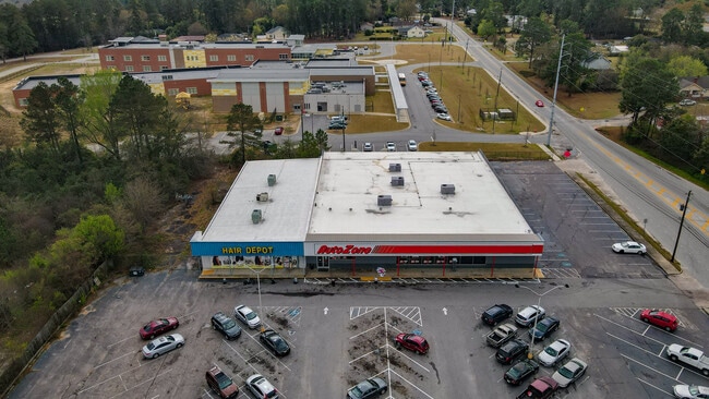
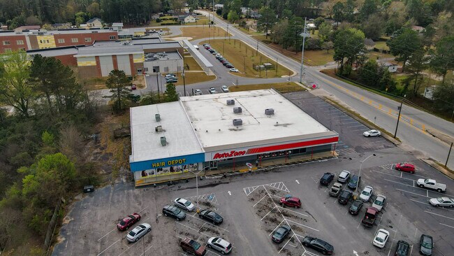
Property Record
2930 Deans Bridge Rd, Augusta, GA 30906

NEARBY LISTINGS FOR SALE OR LEASE
Property Detail
2930 Deans Bridge Rd
0971145000
2930 DEANS BRIDGE RD
Commercialacreage
Richmond
X
Georgia
13245C0120G
2.64 AC
2025
South Richmond County
2025
Augusta/Richmond County
010509
Augusta-Richmond County, GA-SC
20,658 SF
DEMOGRAPHICS near 2930 Deans Bridge Rd
1 Mile
3 Mile
5 Mile
2024 Total Population
8,371
55,305
128,825
2029 Population
8,239
54,774
128,092
Pop Growth 2024-2029
(1.58%)
(0.96%)
(0.57%)
Average Age
38
38
38
2024 Total Households
3,471
21,924
52,669
HH Growth 2024-2029
(1.50%)
(0.87%)
(0.47%)
Median Household Inc
$32,925
$33,259
$44,770
Avg Household Size
2.40
2.40
2.30
2024 Avg HH Vehicles
1.00
2.00
2.00
Median Home Value
$80,178
$84,847
$130,623
Median Year Built
1963
1968
1974
Nearby Places
Map Layers
Map Styles
 Street
 Aerial
- Restaurants
- Banks
- Shops
- Fitness
- Groceries
PUBLIC TRANSPORTATION
AIRPORT
Augusta Regional at Bush Field
DRIVE
WALK
Distance
Augusta Regional at Bush Field
13 min
8.8 mi
SALE & LEASE HISTORY
LISTING DATE
SALE/LEASE

May 22, 2017
For Sale
Mar 24, 2022
For Sale
Jun 20, 2017
For Sale
Apr 04, 2017
For Sale
Nearby Properties
Address
Land Use
TOTAL SIZE
Lot Size
Zoning
Address
Land Use
TOTAL SIZE
Lot Size
Zoning
1,100 SF
97.38 AC
R-1A
Address
Land Use
TOTAL SIZE
Lot Size
Zoning
202,994 SF
19.25 AC
P-1
Address
Land Use
TOTAL SIZE
Lot Size
Zoning
1,428 SF
75.91 AC
R-1A
Address
Land Use
TOTAL SIZE
Lot Size
Zoning
1,620 SF
21.51 AC
R-3B
Address
Land Use
TOTAL SIZE
Lot Size
Zoning
99,046 SF
29.96 AC
R-1A
Address
Land Use
TOTAL SIZE
Lot Size
Zoning
38,080 SF
19.19 AC
R-3B
Address
Land Use
TOTAL SIZE
Lot Size
Zoning
1,782 SF
26.27 AC
R-3A
Address
Land Use
TOTAL SIZE
Lot Size
Zoning
6,323 SF
25.49 AC
R-3C
Address
Land Use
TOTAL SIZE
Lot Size
Zoning
241,284 SF
20.61 AC
R-1A
Address
Land Use
TOTAL SIZE
Lot Size
Zoning
56,631 SF
11.62 AC
R-1A, B-2
Address
Land Use
TOTAL SIZE
Lot Size
Zoning
4,507 SF
56.06 AC
HI
Address
Land Use
TOTAL SIZE
Lot Size
Zoning
4,947 SF
71.24 AC
R-3B
Address
Land Use
TOTAL SIZE
Lot Size
Zoning
16,120 SF
21.38 AC
R-3A
Address
Land Use
TOTAL SIZE
Lot Size
Zoning
14,850 SF
132.49 AC
A,R
Address
Land Use
TOTAL SIZE
Lot Size
Zoning
158,192 SF
48.91 AC
R-1A
Address
Land Use
TOTAL SIZE
Lot Size
Zoning
44,160 SF
12.46 AC
R-3B
Address
Land Use
TOTAL SIZE
Lot Size
Zoning
35,263 SF
19.63 AC
B-1
Address
Land Use
TOTAL SIZE
Lot Size
Zoning
38,412 SF
22.51 AC
R-1A
Address
Land Use
TOTAL SIZE
Lot Size
Zoning
193,478 SF
24.91 AC
B-2
Address
Land Use
TOTAL SIZE
Lot Size
Zoning
24,304 SF
11 AC
R-1A
Address
Land Use
TOTAL SIZE
Lot Size
Zoning
40,824 SF
9.49 AC
R-3B
Address
Land Use
TOTAL SIZE
Lot Size
Zoning
67,713 SF
5.24 AC
LI
Address
Land Use
TOTAL SIZE
Lot Size
Zoning
86,184 SF
9.51 AC
R-3B
Address
Land Use
TOTAL SIZE
Lot Size
Zoning
21,420 SF
16.06 AC
B-2
Address
Land Use
TOTAL SIZE
Lot Size
Zoning
16,790 SF
22.07 AC
B-2
Address
Land Use
TOTAL SIZE
Lot Size
Zoning
73,226 SF
6.97 AC
R-1A
Address
Land Use
TOTAL SIZE
Lot Size
Zoning
66,528 SF
8.99 AC
R-3C
Address
Land Use
TOTAL SIZE
Lot Size
Zoning
70,251 SF
9.17 AC
R-1B
Address
Land Use
TOTAL SIZE
Lot Size
Zoning
47,410 SF
48.05 AC
B-1
Address
Land Use
TOTAL SIZE
Lot Size
Zoning
700 SF
7.12 AC
R-3C
The World's #1 Commercial Real Estate Marketplace
Connect with us
© 2026 CoStar Group
The information above has been obtained from sources believed reliable. While we do not doubt its accuracy we have not verified it and make no guarantee, warranty or representation about it. It is your responsibility to independently confirm its accuracy and completeness. Any projections, opinions, assumptions, or estimates used are for example only and do not represent the current or future performance of the property. The value of this transaction to you depends on tax and other factors which should be evaluated by your tax, financial, and legal advisors. You and your advisors should conduct a careful, independent investigation of the property to determine to your satisfaction the suitability of the property for your needs.