Property Record
2930 Stone Circle Dr, Troy, OH 45373

Property Detail
2930 Stone Circle Dr
Dayton, OH
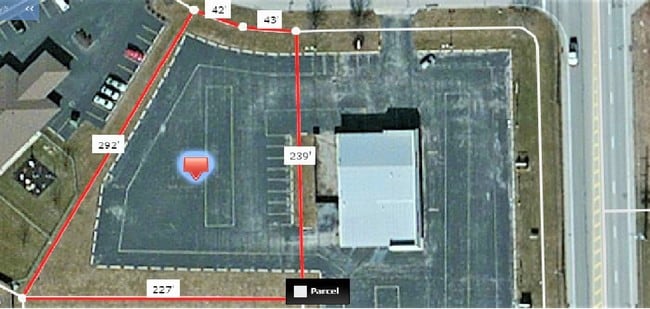
6-4-4 LOT 19 STANDING STONE DEV
C06084002
MIAMI
Vehiclerentalsvehiclesales
Ohio
B and X Area of moderate flood hazard, usually the area between the limits of the 100-year and 500-year floods.
19
2025
0.89 AC
2025
North Dayton
365302
Cincinnati/Dayton
NEARBY LISTINGS FOR SALE OR LEASE
DEMOGRAPHICS near 2930 Stone Circle Dr
1 mile
3 mile
5 mile
2025 Total Population
3,489
22,359
49,582
2030 Population
3,621
23,046
50,985
Pop Growth 2025-2030
+ 3.78%
+ 3.07%
+ 2.83%
Average Age
43
41
42
2025 Total Households
1,359
9,134
20,373
HH Growth 2025-2030
+ 3.61%
+ 3.04%
+ 2.84%
Median Household Inc
$103,178
$81,616
$80,560
Avg Household Size
2.60
2.40
2.40
2025 Avg HH Vehicles
2.00
2.00
2.00
Median Home Value
$341,082
$277,518
$279,586
Median Year Built
1984
1972
1974
Nearby Places
Map Layers
Map Styles
 Street
 Aerial
Layers
 Traffic
 Biking
Places
Listings with unknown addresses are not visible on the map
- Restaurants
- Banks
- Shops
- Fitness
- Groceries
PUBLIC TRANSPORTATION
AIRPORT
James M Cox Dayton International
Drive
Walk
Distance
James M Cox Dayton International
18 min
11.2 mi
SALE & LEASE HISTORY
LISTING DATE
SALE/LEASE

Jul 28, 2017
For Sale
Nearby Properties
Address
Land Use
TOTAL SIZE
Lot Size
Zoning
Address
Land Use
TOTAL SIZE
Lot Size
Zoning
209,484 SF
45.46 AC
Address
Land Use
TOTAL SIZE
Lot Size
Zoning
Address
Land Use
TOTAL SIZE
Lot Size
Zoning
Address
Land Use
TOTAL SIZE
Lot Size
Zoning
38,738 SF
11.39 AC
Address
Land Use
TOTAL SIZE
Lot Size
Zoning
178.04 AC
Address
Land Use
TOTAL SIZE
Lot Size
Zoning
8.94 AC
Address
Land Use
TOTAL SIZE
Lot Size
Zoning
49,496 SF
10.15 AC
Address
Land Use
TOTAL SIZE
Lot Size
Zoning
Address
Land Use
TOTAL SIZE
Lot Size
Zoning
371,869 SF
160.30 AC
Address
Land Use
TOTAL SIZE
Lot Size
Zoning
85.35 AC
Address
Land Use
TOTAL SIZE
Lot Size
Zoning
87,635 SF
6.02 AC
Address
Land Use
TOTAL SIZE
Lot Size
Zoning
85.35 AC
Address
Land Use
TOTAL SIZE
Lot Size
Zoning
Address
Land Use
TOTAL SIZE
Lot Size
Zoning
Address
Land Use
TOTAL SIZE
Lot Size
Zoning
223,905 SF
17.75 AC
Address
Land Use
TOTAL SIZE
Lot Size
Zoning
132,772 SF
15.34 AC
Address
Land Use
TOTAL SIZE
Lot Size
Zoning
198,355 SF
19.64 AC
Address
Land Use
TOTAL SIZE
Lot Size
Zoning
6,263 SF
26.04 AC
Address
Land Use
TOTAL SIZE
Lot Size
Zoning
211,925 SF
13 AC
Address
Land Use
TOTAL SIZE
Lot Size
Zoning
9,900 SF
4.24 AC
Address
Land Use
TOTAL SIZE
Lot Size
Zoning
15,193 SF
5.89 AC
Address
Land Use
TOTAL SIZE
Lot Size
Zoning
16,290 SF
1.14 AC
Address
Land Use
TOTAL SIZE
Lot Size
Zoning
9,832 SF
0.83 AC
Address
Land Use
TOTAL SIZE
Lot Size
Zoning
4,579 SF
0.54 AC
Address
Land Use
TOTAL SIZE
Lot Size
Zoning
96,200 SF
14.09 AC
Address
Land Use
TOTAL SIZE
Lot Size
Zoning
14,850 SF
1.78 AC
Address
Land Use
TOTAL SIZE
Lot Size
Zoning
52,806 SF
3.31 AC
Address
Land Use
TOTAL SIZE
Lot Size
Zoning
8,576 SF
6.19 AC
Address
Land Use
TOTAL SIZE
Lot Size
Zoning
26,250 SF
3.90 AC
Address
Land Use
TOTAL SIZE
Lot Size
Zoning
13,780 SF
1.49 AC
The World's #1 Commercial Real Estate Marketplace
Connect with us
© 2026 CoStar Group
The information above has been obtained from sources believed reliable. While we do not doubt its accuracy we have not verified it and make no guarantee, warranty or representation about it. It is your responsibility to independently confirm its accuracy and completeness. Any projections, opinions, assumptions, or estimates used are for example only and do not represent the current or future performance of the property. The value of this transaction to you depends on tax and other factors which should be evaluated by your tax, financial, and legal advisors. You and your advisors should conduct a careful, independent investigation of the property to determine to your satisfaction the suitability of the property for your needs.