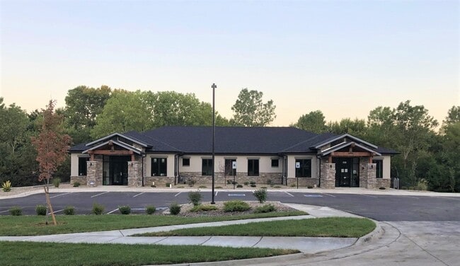
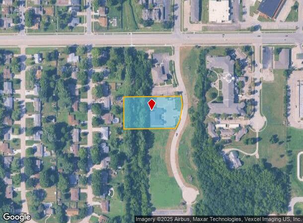
Property Record
2931 Sw Villa West Dr, Topeka, KS 66614

NEARBY LISTINGS FOR SALE OR LEASE
Property Detail
2931 Sw Villa West Dr
Topeka, KS
Sherwood Profess Pk No 2
144-17-0-10-01-006-080
SHERWOOD PROFESS PK NO 2, S17, T12, R15, BLOCK A, LOT 2, ACRES 1.55, BLK A LOT 2 SHERWOOD PROFESSIONAL PARK NO 2
Officebuilding
Shawnee
AE
Kansas
20177C0194E
2
2024
1.55 AC
2025
Topeka
003605
Kansas City
DEMOGRAPHICS near 2931 Sw Villa West Dr
1 Mile
3 Mile
5 Mile
2024 Total Population
9,722
47,352
88,073
2029 Population
9,479
46,476
87,045
Pop Growth 2024-2029
(2.50%)
(1.85%)
(1.17%)
Average Age
44
42
41
2024 Total Households
4,239
20,997
38,522
HH Growth 2024-2029
(2.62%)
(1.95%)
(1.26%)
Median Household Inc
$74,087
$64,264
$56,669
Avg Household Size
2.20
2.20
2.20
2024 Avg HH Vehicles
2.00
2.00
2.00
Median Home Value
$189,131
$169,792
$152,232
Median Year Built
1984
1979
1971
Nearby Places
Map Layers
Map Styles
 Street
 Aerial
- Restaurants
- Banks
- Shops
- Fitness
- Groceries
PUBLIC TRANSPORTATION
COMMUTER RAIL
DRIVE
WALK
Distance
15 min
9.1 mi
SALE & LEASE HISTORY
LISTING DATE
SALE/LEASE

Oct 15, 2020
For Lease
Oct 13, 2022
For Lease
Nearby Properties
Address
Land Use
TOTAL SIZE
Lot Size
Zoning
Address
Land Use
TOTAL SIZE
Lot Size
Zoning
80,630 SF
107.16 AC
R1
Address
Land Use
TOTAL SIZE
Lot Size
Zoning
43,282 SF
19.33 AC
PUD,M2
Address
Land Use
TOTAL SIZE
Lot Size
Zoning
218,962 SF
49.63 AC
R1
Address
Land Use
TOTAL SIZE
Lot Size
Zoning
208,685 SF
38.23 AC
R1
Address
Land Use
TOTAL SIZE
Lot Size
Zoning
52,375 SF
12.94 AC
RR1
Address
Land Use
TOTAL SIZE
Lot Size
Zoning
88,935 SF
20.24 AC
C4
Address
Land Use
TOTAL SIZE
Lot Size
Zoning
175,246 SF
80.42 AC
R1
Address
Land Use
TOTAL SIZE
Lot Size
Zoning
6.95 AC
PUD,OI1
Address
Land Use
TOTAL SIZE
Lot Size
Zoning
81,364 SF
19.52 AC
R1
Address
Land Use
TOTAL SIZE
Lot Size
Zoning
53,136 SF
18.28 AC
PUD,M2
Address
Land Use
TOTAL SIZE
Lot Size
Zoning
11.05 AC
PUD,C2,C4,
Address
Land Use
TOTAL SIZE
Lot Size
Zoning
38,087 SF
10.27 AC
PUD,M4
Address
Land Use
TOTAL SIZE
Lot Size
Zoning
84,510 SF
5.95 AC
M2
Address
Land Use
TOTAL SIZE
Lot Size
Zoning
71,575 SF
10.93 AC
C2,C4
Address
Land Use
TOTAL SIZE
Lot Size
Zoning
22,194 SF
3.59 AC
M4
Address
Land Use
TOTAL SIZE
Lot Size
Zoning
19,892 SF
3.51 AC
M4
Address
Land Use
TOTAL SIZE
Lot Size
Zoning
31,132 SF
111.36 AC
R1
Address
Land Use
TOTAL SIZE
Lot Size
Zoning
19.37 AC
Address
Land Use
TOTAL SIZE
Lot Size
Zoning
33,487 SF
2.65 AC
R1
Address
Land Use
TOTAL SIZE
Lot Size
Zoning
59,337 SF
6.84 AC
R1
Address
Land Use
TOTAL SIZE
Lot Size
Zoning
72,482 SF
19.53 AC
R1
Address
Land Use
TOTAL SIZE
Lot Size
Zoning
51,636 SF
3.89 AC
C4
Address
Land Use
TOTAL SIZE
Lot Size
Zoning
57,380 SF
15.03 AC
RR1
Address
Land Use
TOTAL SIZE
Lot Size
Zoning
74,659 SF
15.24 AC
RR1
Address
Land Use
TOTAL SIZE
Lot Size
Zoning
50,795 SF
7.70 AC
R1
Address
Land Use
TOTAL SIZE
Lot Size
Zoning
36,511 SF
7.05 AC
R1
Address
Land Use
TOTAL SIZE
Lot Size
Zoning
61,383 SF
8.09 AC
R1
Address
Land Use
TOTAL SIZE
Lot Size
Zoning
58,568 SF
8.73 AC
R1
Address
Land Use
TOTAL SIZE
Lot Size
Zoning
135,625 SF
23.52 AC
PUD,M2
Address
Land Use
TOTAL SIZE
Lot Size
Zoning
37,132 SF
13.48 AC
R1
The World's #1 Commercial Real Estate Marketplace
Connect with us
© 2025 CoStar Group
The information above has been obtained from sources believed reliable. While we do not doubt its accuracy we have not verified it and make no guarantee, warranty or representation about it. It is your responsibility to independently confirm its accuracy and completeness. Any projections, opinions, assumptions, or estimates used are for example only and do not represent the current or future performance of the property. The value of this transaction to you depends on tax and other factors which should be evaluated by your tax, financial, and legal advisors. You and your advisors should conduct a careful, independent investigation of the property to determine to your satisfaction the suitability of the property for your needs.