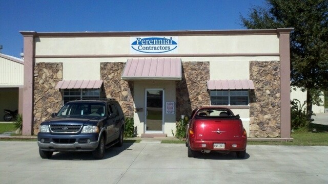
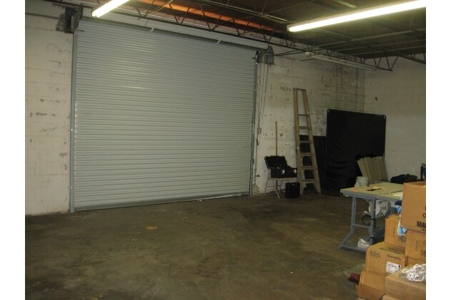
Property Record
2927 Highway 90 St E, Broussard, LA 70518

Property Detail
2927 Highway 90 St E
6072119
TR 2 SEC 52 T10S R5E (1.143 AC)
Warehouse
Lafayette
B and X Area of moderate flood hazard, usually the area between the limits of the 100-year and 500-year floods.
Louisiana
2025
1.14 AC
2025
Greater Lafayette
000606
Lafayette
3,041 SF
Lafayette, LA
NEARBY LISTINGS FOR SALE OR LEASE
DEMOGRAPHICS near 2927 Highway 90 St E
1 mile
3 mile
5 mile
2025 Total Population
360
30,510
105,353
2030 Population
392
31,944
110,066
Pop Growth 2025-2030
+ 8.89%
+ 4.70%
+ 4.47%
Average Age
40
40
40
2025 Total Households
134
13,097
44,394
HH Growth 2025-2030
+ 10.45%
+ 4.86%
+ 4.62%
Median Household Inc
$32,812
$70,052
$67,392
Avg Household Size
2.40
2.30
2.30
2025 Avg HH Vehicles
1.00
2.00
2.00
Median Home Value
$215,789
$278,328
$281,510
Median Year Built
2000
1989
1985
Nearby Places
Map Layers
Map Styles
 Street
 Aerial
Layers
 Traffic
 Biking
Places
Listings with unknown addresses are not visible on the map
- Restaurants
- Banks
- Shops
- Fitness
- Groceries
PUBLIC TRANSPORTATION
AIRPORT
Lafayette Regional/Paul Fournet Field
Drive
Walk
Distance
Lafayette Regional/Paul Fournet Field
6 min
3.4 mi
SALE & LEASE HISTORY
LISTING DATE
SALE/LEASE

Aug 06, 2024
For Lease
Nearby Properties
Address
Land Use
TOTAL SIZE
Lot Size
Zoning
Address
Land Use
TOTAL SIZE
Lot Size
Zoning
800,608 SF
6.64 AC
Address
Land Use
TOTAL SIZE
Lot Size
Zoning
82,329 SF
1 AC
Address
Land Use
TOTAL SIZE
Lot Size
Zoning
273,165 SF
15.14 AC
Address
Land Use
TOTAL SIZE
Lot Size
Zoning
141,706 SF
3.44 AC
Address
Land Use
TOTAL SIZE
Lot Size
Zoning
70,972 SF
921.26 AC
Address
Land Use
TOTAL SIZE
Lot Size
Zoning
273,675 SF
6.38 AC
Address
Land Use
TOTAL SIZE
Lot Size
Zoning
20,775 SF
11.04 AC
Address
Land Use
TOTAL SIZE
Lot Size
Zoning
158,272 SF
Address
Land Use
TOTAL SIZE
Lot Size
Zoning
145,412 SF
0.01 AC
Address
Land Use
TOTAL SIZE
Lot Size
Zoning
67,949 SF
0.92 AC
Address
Land Use
TOTAL SIZE
Lot Size
Zoning
11,778 SF
15.25 AC
Address
Land Use
TOTAL SIZE
Lot Size
Zoning
98,973 SF
9.91 AC
Address
Land Use
TOTAL SIZE
Lot Size
Zoning
900 SF
12.41 AC
Address
Land Use
TOTAL SIZE
Lot Size
Zoning
210,169 SF
20.75 AC
Address
Land Use
TOTAL SIZE
Lot Size
Zoning
84,225 SF
Address
Land Use
TOTAL SIZE
Lot Size
Zoning
194,912 SF
13.73 AC
Address
Land Use
TOTAL SIZE
Lot Size
Zoning
74,343 SF
8.88 AC
Address
Land Use
TOTAL SIZE
Lot Size
Zoning
106,686 SF
7.03 AC
Address
Land Use
TOTAL SIZE
Lot Size
Zoning
151,863 SF
1.43 AC
Address
Land Use
TOTAL SIZE
Lot Size
Zoning
205,096 SF
21.71 AC
Address
Land Use
TOTAL SIZE
Lot Size
Zoning
61,913 SF
10 AC
Address
Land Use
TOTAL SIZE
Lot Size
Zoning
83,756 SF
Address
Land Use
TOTAL SIZE
Lot Size
Zoning
9.02 AC
Address
Land Use
TOTAL SIZE
Lot Size
Zoning
5,625 SF
25.86 AC
Address
Land Use
TOTAL SIZE
Lot Size
Zoning
2,774 SF
51.89 AC
Address
Land Use
TOTAL SIZE
Lot Size
Zoning
19,424 SF
8.82 AC
Address
Land Use
TOTAL SIZE
Lot Size
Zoning
141,600 SF
24.31 AC
Address
Land Use
TOTAL SIZE
Lot Size
Zoning
122,362 SF
4.28 AC
Address
Land Use
TOTAL SIZE
Lot Size
Zoning
91,619 SF
5.48 AC
Address
Land Use
TOTAL SIZE
Lot Size
Zoning
19,041 SF
14.76 AC
The World's #1 Commercial Real Estate Marketplace
Connect with us
© 2026 CoStar Group
The information above has been obtained from sources believed reliable. While we do not doubt its accuracy we have not verified it and make no guarantee, warranty or representation about it. It is your responsibility to independently confirm its accuracy and completeness. Any projections, opinions, assumptions, or estimates used are for example only and do not represent the current or future performance of the property. The value of this transaction to you depends on tax and other factors which should be evaluated by your tax, financial, and legal advisors. You and your advisors should conduct a careful, independent investigation of the property to determine to your satisfaction the suitability of the property for your needs.