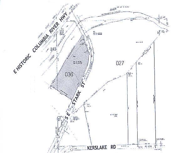
Property Record
29311 Se Stark St, Troutdale, OR 97060
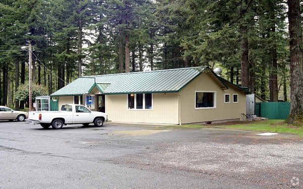

Property Detail
29311 Se Stark St
R341487
SECTION 06 1S 4E, TL 700 3.77 ACRES UPLAND 1.25 ACRES LOWLAND
Commercialnec
Multnomah
RR
Oregon
B and X Area of moderate flood hazard, usually the area between the limits of the 100-year and 500-year floods.
5.02 AC
2025
East Columbia Corridor
2025
Portland
010402
Portland-Vancouver-Hillsboro, OR-WA
5,112 SF
NEARBY LISTINGS FOR SALE OR LEASE
DEMOGRAPHICS near 29311 Se Stark St
1 mile
3 mile
5 mile
2024 Total Population
1,993
50,319
115,110
2029 Population
1,929
49,357
113,682
Pop Growth 2024-2029
(3.21%)
(1.91%)
(1.24%)
Average Age
43
40
40
2024 Total Households
697
18,030
41,931
HH Growth 2024-2029
(3.59%)
(2.27%)
(1.45%)
Median Household Inc
$109,308
$78,207
$79,622
Avg Household Size
2.80
2.70
2.70
2024 Avg HH Vehicles
3.00
2.00
2.00
Median Home Value
$480,039
$454,467
$456,314
Median Year Built
1978
1985
1984
Nearby Places
Map Layers
Map Styles
 Street
 Aerial
Transit
 Traffic
 Biking
Places
Listings with unknown addresses are not visible on the map
- Restaurants
- Banks
- Shops
- Fitness
- Groceries
PUBLIC TRANSPORTATION
AIRPORT
Portland International
Drive
Walk
Distance
Portland International
27 min
16.8 mi
Freight Ports
Port of Portland
Drive
Walk
Distance
Port of Portland
33 min
22.2 mi
Nearby Properties
Address
Land Use
TOTAL SIZE
Lot Size
Zoning
Address
Land Use
TOTAL SIZE
Lot Size
Zoning
40.81 AC
LDR-5
Address
Land Use
TOTAL SIZE
Lot Size
Zoning
3.20 AC
DEM
Address
Land Use
TOTAL SIZE
Lot Size
Zoning
300,843 SF
37.27 AC
MUA20
Address
Land Use
TOTAL SIZE
Lot Size
Zoning
302,114 SF
31.69 AC
R-5
Address
Land Use
TOTAL SIZE
Lot Size
Zoning
836,366 SF
38.86 AC
LI
Address
Land Use
TOTAL SIZE
Lot Size
Zoning
14,059 SF
12.83 AC
GI
Address
Land Use
TOTAL SIZE
Lot Size
Zoning
197,834 SF
8.67 AC
R5
Address
Land Use
TOTAL SIZE
Lot Size
Zoning
213,544 SF
6.64 AC
A2
Address
Land Use
TOTAL SIZE
Lot Size
Zoning
273,264 SF
11.39 AC
CMF
Address
Land Use
TOTAL SIZE
Lot Size
Zoning
156,393 SF
5.82 AC
GC
Address
Land Use
TOTAL SIZE
Lot Size
Zoning
115,600 SF
28.24 AC
LDR-5
Address
Land Use
TOTAL SIZE
Lot Size
Zoning
235,728 SF
6.64 AC
MDR-24
Address
Land Use
TOTAL SIZE
Lot Size
Zoning
65,461 SF
7.90 AC
LDR-5
Address
Land Use
TOTAL SIZE
Lot Size
Zoning
188,870 SF
17.13 AC
CC
Address
Land Use
TOTAL SIZE
Lot Size
Zoning
60,280 SF
10.62 AC
LDR
Address
Land Use
TOTAL SIZE
Lot Size
Zoning
73,073 SF
1.37 AC
R-5
Address
Land Use
TOTAL SIZE
Lot Size
Zoning
203,148 SF
8.58 AC
MDR-24
Address
Land Use
TOTAL SIZE
Lot Size
Zoning
187,027 SF
9.09 AC
MDR-24
Address
Land Use
TOTAL SIZE
Lot Size
Zoning
85,520 SF
14.13 AC
R-7
Address
Land Use
TOTAL SIZE
Lot Size
Zoning
136,140 SF
25.20 AC
GC
Address
Land Use
TOTAL SIZE
Lot Size
Zoning
169,778 SF
7.32 AC
A-2
Address
Land Use
TOTAL SIZE
Lot Size
Zoning
31.05 AC
MDR12
Address
Land Use
TOTAL SIZE
Lot Size
Zoning
145,952 SF
8.95 AC
CMF
Address
Land Use
TOTAL SIZE
Lot Size
Zoning
117,771 SF
16.50 AC
GC
Address
Land Use
TOTAL SIZE
Lot Size
Zoning
223,692 SF
12.96 AC
A-2
Address
Land Use
TOTAL SIZE
Lot Size
Zoning
143,039 SF
8.02 AC
MDR24
Address
Land Use
TOTAL SIZE
Lot Size
Zoning
0.69 AC
LDR-5
Address
Land Use
TOTAL SIZE
Lot Size
Zoning
176,439 SF
9.15 AC
MDR24
Address
Land Use
TOTAL SIZE
Lot Size
Zoning
112,795 SF
8.53 AC
CC
Address
Land Use
TOTAL SIZE
Lot Size
Zoning
72,000 SF
7.02 AC
GI
The World's #1 Commercial Real Estate Marketplace
Connect with us
© 2026 CoStar Group
The information above has been obtained from sources believed reliable. While we do not doubt its accuracy we have not verified it and make no guarantee, warranty or representation about it. It is your responsibility to independently confirm its accuracy and completeness. Any projections, opinions, assumptions, or estimates used are for example only and do not represent the current or future performance of the property. The value of this transaction to you depends on tax and other factors which should be evaluated by your tax, financial, and legal advisors. You and your advisors should conduct a careful, independent investigation of the property to determine to your satisfaction the suitability of the property for your needs.