Property Record
29317 Cliffside Dr, Malibu, CA 90265
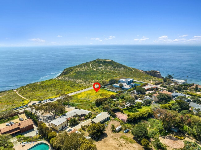


Property Detail
29317 Cliffside Dr
Los Angeles-Long Beach-Glendale, CA
P M 200-20 LOT 2
4468-003-025
LOS ANGELES
Residentialacreage
California
LCRR1*
2
B and X Area of moderate flood hazard, usually the area between the limits of the 100-year and 500-year floods.
0.92 AC
2024
Pacific Palisades/Malibu
2025
Los Angeles
800412
NEARBY LISTINGS FOR SALE OR LEASE
DEMOGRAPHICS near 29317 Cliffside Dr
1 mile
3 mile
5 mile
2025 Total Population
1,997
7,126
10,737
2030 Population
2,119
7,524
11,317
Pop Growth 2025-2030
+ 6.11%
+ 5.59%
+ 5.40%
Average Age
46
47
45
2025 Total Households
820
2,862
4,024
HH Growth 2025-2030
+ 5.98%
+ 5.45%
+ 5.77%
Median Household Inc
$159,615
$180,182
$185,081
Avg Household Size
2.40
2.50
2.40
2025 Avg HH Vehicles
2.00
2.00
2.00
Median Home Value
$1,110,842
$1,125,334
$1,128,910
Median Year Built
1977
1978
1977
Nearby Places
Map Layers
Map Styles
 Street
 Aerial
Layers
 Traffic
 Biking
Places
Listings with unknown addresses are not visible on the map
- Restaurants
- Banks
- Shops
- Fitness
- Groceries
PUBLIC TRANSPORTATION
AIRPORT
Los Angeles International
Drive
Walk
Distance
Los Angeles International
52 min
28.8 mi
Bob Hope
Drive
Walk
Distance
Bob Hope
59 min
41.4 mi
Freight Ports
The Port of Hueneme
Drive
Walk
Distance
The Port of Hueneme
40 min
27.7 mi
SALE & LEASE HISTORY
LISTING DATE
SALE/LEASE

Mar 14, 2024
For Sale
Nearby Properties
Address
Land Use
TOTAL SIZE
Lot Size
Zoning
Address
Land Use
TOTAL SIZE
Lot Size
Zoning
41,478 SF
13.39 AC
MACC
Address
Land Use
TOTAL SIZE
Lot Size
Zoning
83,298 SF
2.46 AC
LCC3*
Address
Land Use
TOTAL SIZE
Lot Size
Zoning
0.93 AC
LCRA1*
Address
Land Use
TOTAL SIZE
Lot Size
Zoning
64,471 SF
1.30 AC
LCC3*
Address
Land Use
TOTAL SIZE
Lot Size
Zoning
3,354 SF
0.73 AC
LCR3-1*
Address
Land Use
TOTAL SIZE
Lot Size
Zoning
1,050 SF
0.23 AC
LCR171/2
Address
Land Use
TOTAL SIZE
Lot Size
Zoning
1.05 AC
LCRA1*
Address
Land Use
TOTAL SIZE
Lot Size
Zoning
0.42 AC
LCR110000*
Address
Land Use
TOTAL SIZE
Lot Size
Zoning
2.94 AC
LCR111000*
Address
Land Use
TOTAL SIZE
Lot Size
Zoning
30,629 SF
1.62 AC
LCC2*
Address
Land Use
TOTAL SIZE
Lot Size
Zoning
1.22 AC
LCRA1*
Address
Land Use
TOTAL SIZE
Lot Size
Zoning
3.08 AC
LCR11*
Address
Land Use
TOTAL SIZE
Lot Size
Zoning
2.14 AC
LCRA1*
Address
Land Use
TOTAL SIZE
Lot Size
Zoning
9.87 AC
LCRA1Y
Address
Land Use
TOTAL SIZE
Lot Size
Zoning
13,370 SF
3.95 AC
LCRA1Y
Address
Land Use
TOTAL SIZE
Lot Size
Zoning
15,991 SF
0.43 AC
LCC1-2*
Address
Land Use
TOTAL SIZE
Lot Size
Zoning
1.18 AC
LCRA1*
Address
Land Use
TOTAL SIZE
Lot Size
Zoning
11,854 SF
3.21 AC
LCR3*
Address
Land Use
TOTAL SIZE
Lot Size
Zoning
0.50 AC
LCRR10
Address
Land Use
TOTAL SIZE
Lot Size
Zoning
0.53 AC
LCRR10
Address
Land Use
TOTAL SIZE
Lot Size
Zoning
0.55 AC
LCRR10
Address
Land Use
TOTAL SIZE
Lot Size
Zoning
0.54 AC
LCRR10
Address
Land Use
TOTAL SIZE
Lot Size
Zoning
1.08 AC
LCRA1*
Address
Land Use
TOTAL SIZE
Lot Size
Zoning
3,008 SF
0.57 AC
LCRA1*
Address
Land Use
TOTAL SIZE
Lot Size
Zoning
2.57 AC
LCRA20
Address
Land Use
TOTAL SIZE
Lot Size
Zoning
10.17 AC
LCC2-R1110
Address
Land Use
TOTAL SIZE
Lot Size
Zoning
0.51 AC
LCR120000*
Address
Land Use
TOTAL SIZE
Lot Size
Zoning
2.23 AC
LCR120
Address
Land Use
TOTAL SIZE
Lot Size
Zoning
2,166 SF
6.55 AC
LCRA1*
The World's #1 Commercial Real Estate Marketplace
Connect with us
© 2026 CoStar Group
The information above has been obtained from sources believed reliable. While we do not doubt its accuracy we have not verified it and make no guarantee, warranty or representation about it. It is your responsibility to independently confirm its accuracy and completeness. Any projections, opinions, assumptions, or estimates used are for example only and do not represent the current or future performance of the property. The value of this transaction to you depends on tax and other factors which should be evaluated by your tax, financial, and legal advisors. You and your advisors should conduct a careful, independent investigation of the property to determine to your satisfaction the suitability of the property for your needs.