Property Record
2932 Athens Hwy, Gainesville, GA 30507

NEARBY LISTINGS FOR SALE OR LEASE
Property Detail
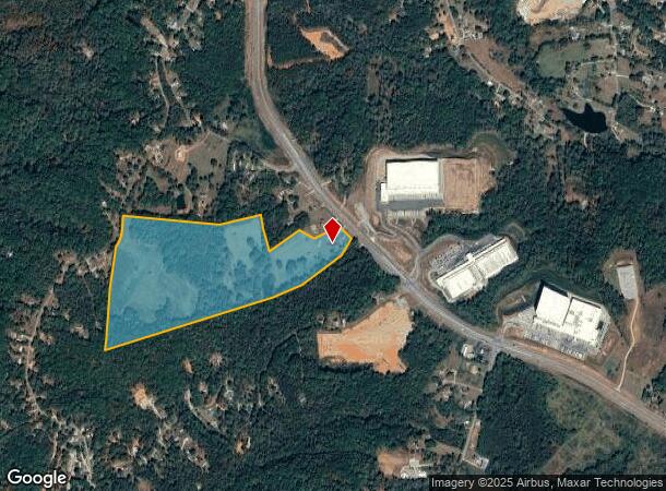
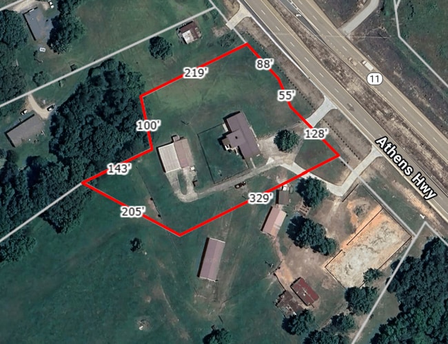
2932 Athens Hwy
15-00024-00-041
2932 ATHENS HIGHWAY
Agriculturalland
Hall
A
Georgia
13013C0025D
61.12 AC
2025
Gainesville/Hall County
2025
Atlanta
001202
Gainesville, GA
DEMOGRAPHICS near 2932 Athens Hwy
1 Mile
3 Mile
5 Mile
2024 Total Population
1,000
14,272
40,224
2029 Population
1,112
15,751
44,566
Pop Growth 2024-2029
+ 11.20%
+ 10.36%
+ 10.79%
Average Age
33
34
35
2024 Total Households
262
3,752
11,583
HH Growth 2024-2029
+ 11.07%
+ 10.31%
+ 10.70%
Median Household Inc
$51,515
$55,400
$54,852
Avg Household Size
3.80
3.60
3.30
2024 Avg HH Vehicles
3.00
2.00
2.00
Median Home Value
$214,045
$192,320
$202,288
Median Year Built
2000
1997
1994
Nearby Places
Map Layers
Map Styles
 Street
 Aerial
- Restaurants
- Banks
- Shops
- Fitness
- Groceries
PUBLIC TRANSPORTATION
COMMUTER RAIL
Gainesville Amtrak Station (Crescent - Amtrak)
DRIVE
WALK
Distance
Gainesville Amtrak Station (Crescent - Amtrak)
8 min
6.6 mi
Freight Ports
Georgia Ports - Savannah
DRIVE
WALK
Distance
Georgia Ports - Savannah
308 min
244.8 mi
SALE & LEASE HISTORY
LISTING DATE
SALE/LEASE

Aug 15, 2019
For Sale
Nearby Properties
Address
Land Use
TOTAL SIZE
Lot Size
Zoning
Address
Land Use
TOTAL SIZE
Lot Size
Zoning
578,645 SF
110.18 AC
PUD
Address
Land Use
TOTAL SIZE
Lot Size
Zoning
334,800 SF
56.96 AC
PUD
Address
Land Use
TOTAL SIZE
Lot Size
Zoning
273,931 SF
34.09 AC
I-1
Address
Land Use
TOTAL SIZE
Lot Size
Zoning
258,201 SF
38.83 AC
I-1
Address
Land Use
TOTAL SIZE
Lot Size
Zoning
346,875 SF
82.09 AC
H-I
Address
Land Use
TOTAL SIZE
Lot Size
Zoning
54,751 SF
33.38 AC
AR-1
Address
Land Use
TOTAL SIZE
Lot Size
Zoning
88,042 SF
280.24 AC
PID
Address
Land Use
TOTAL SIZE
Lot Size
Zoning
258,800 SF
52.20 AC
H-I
Address
Land Use
TOTAL SIZE
Lot Size
Zoning
18,126 SF
14.65 AC
AR-1
Address
Land Use
TOTAL SIZE
Lot Size
Zoning
145,064 SF
7.47 AC
I-1
Address
Land Use
TOTAL SIZE
Lot Size
Zoning
14,980 SF
136.15 AC
AR-1
Address
Land Use
TOTAL SIZE
Lot Size
Zoning
78,042 SF
42.75 AC
AR-1
Address
Land Use
TOTAL SIZE
Lot Size
Zoning
175,512 SF
I-1
Address
Land Use
TOTAL SIZE
Lot Size
Zoning
215,108 SF
26.97 AC
I-2
Address
Land Use
TOTAL SIZE
Lot Size
Zoning
111,520 SF
21.85 AC
PUD
Address
Land Use
TOTAL SIZE
Lot Size
Zoning
6,502 SF
370.58 AC
AR-1
Address
Land Use
TOTAL SIZE
Lot Size
Zoning
89.89 AC
AR-III
Address
Land Use
TOTAL SIZE
Lot Size
Zoning
8,160 SF
34.21 AC
H-B
Address
Land Use
TOTAL SIZE
Lot Size
Zoning
1,805 SF
21.53 AC
PID
Address
Land Use
TOTAL SIZE
Lot Size
Zoning
85,267 SF
9.98 AC
I-2
Address
Land Use
TOTAL SIZE
Lot Size
Zoning
23,280 SF
52.82 AC
AR-1
Address
Land Use
TOTAL SIZE
Lot Size
Zoning
41,455 SF
25.48 AC
I-1
Address
Land Use
TOTAL SIZE
Lot Size
Zoning
5,000 SF
24.83 AC
I-2/AR-1
Address
Land Use
TOTAL SIZE
Lot Size
Zoning
31.92 AC
PUD
Address
Land Use
TOTAL SIZE
Lot Size
Zoning
1,228 SF
75.09 AC
PID
Address
Land Use
TOTAL SIZE
Lot Size
Zoning
13,500 SF
14.26 AC
I-2
Address
Land Use
TOTAL SIZE
Lot Size
Zoning
15,000 SF
6.07 AC
I-1
Address
Land Use
TOTAL SIZE
Lot Size
Zoning
11,152 SF
23.39 AC
AR-1
Address
Land Use
TOTAL SIZE
Lot Size
Zoning
36,600 SF
5.02 AC
I-2
Address
Land Use
TOTAL SIZE
Lot Size
Zoning
4,308 SF
31.38 AC
AR-1
The World's #1 Commercial Real Estate Marketplace
Connect with us
© 2025 CoStar Group
The information above has been obtained from sources believed reliable. While we do not doubt its accuracy we have not verified it and make no guarantee, warranty or representation about it. It is your responsibility to independently confirm its accuracy and completeness. Any projections, opinions, assumptions, or estimates used are for example only and do not represent the current or future performance of the property. The value of this transaction to you depends on tax and other factors which should be evaluated by your tax, financial, and legal advisors. You and your advisors should conduct a careful, independent investigation of the property to determine to your satisfaction the suitability of the property for your needs.