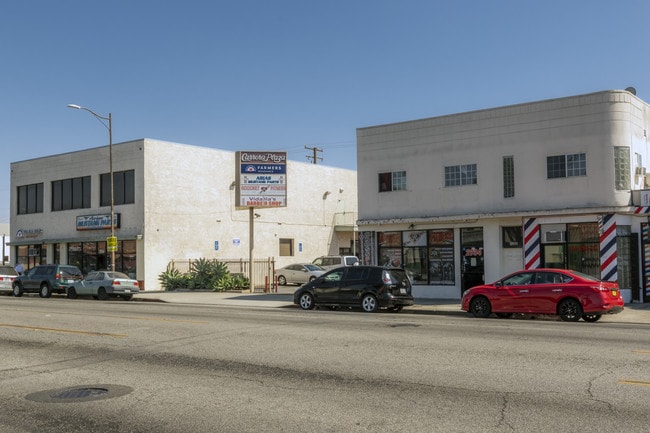
Property Record
2825 Walnut St, Huntington Park, CA 90255

Current Lease Availabilities
NEARBY LISTINGS FOR SALE OR LEASE
Property Detail
2825 Walnut St
Los Angeles-Long Beach-Glendale, CA
2080
6201-001-021
TRACT # 2080 LOT 115
Quadruplex
Los Angeles
X
California
06037C1805F
115
2024
0.13 AC
2025
Mid-Cities
534802
Los Angeles
2,798 SF
DEMOGRAPHICS near 2825 Walnut St
1 Mile
3 Mile
5 Mile
2024 Total Population
57,023
349,774
933,568
2029 Population
53,885
331,838
888,792
Pop Growth 2024-2029
(5.50%)
(5.13%)
(4.80%)
Average Age
37
35
35
2024 Total Households
15,224
87,297
235,202
HH Growth 2024-2029
(5.82%)
(5.49%)
(5.13%)
Median Household Inc
$56,013
$53,575
$52,982
Avg Household Size
3.60
3.80
3.70
2024 Avg HH Vehicles
2.00
2.00
2.00
Median Home Value
$580,699
$525,132
$549,688
Median Year Built
1949
1953
1953
Nearby Places
- Restaurants
- Banks
- Shops
- Fitness
- Groceries
PUBLIC TRANSPORTATION
COMMUTER RAIL
Commerce (91 Line - Southern California Regional Rail Authority (Metrolink), Orange County Line - Southern California Regional Rail Authority (Metrolink))
DRIVE
WALK
Distance
Commerce (91 Line - Southern California Regional Rail Authority (Metrolink), Orange County Line - Southern California Regional Rail Authority (Metrolink))
12 min
6.0 mi
Union Station (91 Line - Southern California Regional Rail Authority (Metrolink), Antelope Valley Line - Southern California Regional Rail Authority (Metrolink), Orange County Line - Southern California Regional Rail Authority (Metrolink), Riverside Line - Southern California Regional Rail Authority (Metrolink), San Bernardino Line - Southern California Regional Rail Authority (Metrolink), Ventura County Line - Southern California Regional Rail Authority (Metrolink))
DRIVE
WALK
Distance
Union Station (91 Line - Southern California Regional Rail Authority (Metrolink), Antelope Valley Line - Southern California Regional Rail Authority (Metrolink), Orange County Line - Southern California Regional Rail Authority (Metrolink), Riverside Line - Southern California Regional Rail Authority (Metrolink), San Bernardino Line - Southern California Regional Rail Authority (Metrolink), Ventura County Line - Southern California Regional Rail Authority (Metrolink))
15 min
6.9 mi
AIRPORT
Los Angeles International
DRIVE
WALK
Distance
Los Angeles International
23 min
12.4 mi
Long Beach (Daugherty Field)
DRIVE
WALK
Distance
Long Beach (Daugherty Field)
24 min
15.5 mi
Bob Hope
DRIVE
WALK
Distance
Bob Hope
33 min
22.4 mi
Freight Ports
Port of Long Beach
DRIVE
WALK
Distance
Port of Long Beach
26 min
18.3 mi
Nearby Properties
Address
Land Use
TOTAL SIZE
Lot Size
Zoning
Address
Land Use
TOTAL SIZE
Lot Size
Zoning
227,179 SF
10.46 AC
VEM*
Address
Land Use
TOTAL SIZE
Lot Size
Zoning
326,472 SF
14.53 AC
VEM*
Address
Land Use
TOTAL SIZE
Lot Size
Zoning
51,000 SF
27.18 AC
SGM3
Address
Land Use
TOTAL SIZE
Lot Size
Zoning
188,319 SF
11.25 AC
VEM&MS1*
Address
Land Use
TOTAL SIZE
Lot Size
Zoning
108,598 SF
15.93 AC
LCC3*
Address
Land Use
TOTAL SIZE
Lot Size
Zoning
Address
Land Use
TOTAL SIZE
Lot Size
Zoning
330,904 SF
12.09 AC
VEM*
Address
Land Use
TOTAL SIZE
Lot Size
Zoning
260,714 SF
9.99 AC
VEM*
Address
Land Use
TOTAL SIZE
Lot Size
Zoning
116,728 SF
0.86 AC
HPCP*
Address
Land Use
TOTAL SIZE
Lot Size
Zoning
372,634 SF
10.83 AC
VEM*
Address
Land Use
TOTAL SIZE
Lot Size
Zoning
369,554 SF
8.49 AC
VEM*
Address
Land Use
TOTAL SIZE
Lot Size
Zoning
43,406 SF
5.67 AC
SGM2
Address
Land Use
TOTAL SIZE
Lot Size
Zoning
261,540 SF
10.85 AC
VEM*
Address
Land Use
TOTAL SIZE
Lot Size
Zoning
100,515 SF
7.45 AC
VEM&MS1*
Address
Land Use
TOTAL SIZE
Lot Size
Zoning
386,865 SF
6 AC
VEM*
Address
Land Use
TOTAL SIZE
Lot Size
Zoning
108,641 SF
5.34 AC
VEM*
Address
Land Use
TOTAL SIZE
Lot Size
Zoning
353,151 SF
8.28 AC
VEM*
Address
Land Use
TOTAL SIZE
Lot Size
Zoning
289,913 SF
8.25 AC
VEM*
Address
Land Use
TOTAL SIZE
Lot Size
Zoning
726,275 SF
14.41 AC
VEM*
Address
Land Use
TOTAL SIZE
Lot Size
Zoning
149,846 SF
5.85 AC
VEM*
Address
Land Use
TOTAL SIZE
Lot Size
Zoning
99,065 SF
4.51 AC
VEM*
Address
Land Use
TOTAL SIZE
Lot Size
Zoning
183,319 SF
9.77 AC
VEM*
Address
Land Use
TOTAL SIZE
Lot Size
Zoning
2.65 AC
HPM2
Address
Land Use
TOTAL SIZE
Lot Size
Zoning
97,218 SF
9.64 AC
SGM2
Address
Land Use
TOTAL SIZE
Lot Size
Zoning
132,544 SF
3.24 AC
LAM2
Address
Land Use
TOTAL SIZE
Lot Size
Zoning
196,676 SF
9.80 AC
SGM3
Address
Land Use
TOTAL SIZE
Lot Size
Zoning
115,340 SF
3.21 AC
LAM2
Address
Land Use
TOTAL SIZE
Lot Size
Zoning
109,400 SF
11.24 AC
LAM3
Address
Land Use
TOTAL SIZE
Lot Size
Zoning
127,484 SF
7.33 AC
LAM2
Address
Land Use
TOTAL SIZE
Lot Size
Zoning
165,235 SF
1.13 AC
LAM2
The World's #1 Commercial Real Estate Marketplace
Connect with us
© 2025 CoStar Group
The information above has been obtained from sources believed reliable. While we do not doubt its accuracy we have not verified it and make no guarantee, warranty or representation about it. It is your responsibility to independently confirm its accuracy and completeness. Any projections, opinions, assumptions, or estimates used are for example only and do not represent the current or future performance of the property. The value of this transaction to you depends on tax and other factors which should be evaluated by your tax, financial, and legal advisors. You and your advisors should conduct a careful, independent investigation of the property to determine to your satisfaction the suitability of the property for your needs.