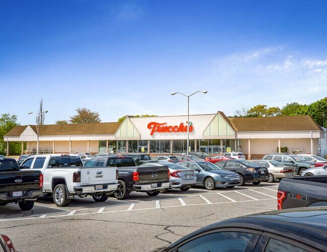
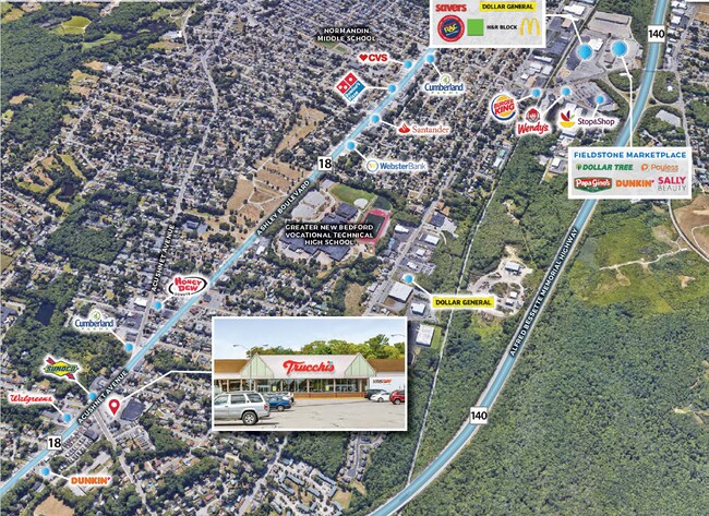
Property Record
2935 Acushnet Ave, New Bedford, MA 02745

NEARBY LISTINGS FOR SALE OR LEASE
Property Detail
2935 Acushnet Ave
NEWB-000132-000000-000020
Bristol
Supermarket
Massachusetts
X
20
25005C0383H
3.84 AC
2025
Attleboro/New Bedford
2025
Boston
650102
Providence-Warwick, RI-MA
32,588 SF
DEMOGRAPHICS near 2935 Acushnet Ave
1 Mile
3 Mile
5 Mile
2024 Total Population
7,852
47,324
100,831
2029 Population
7,806
46,560
99,013
Pop Growth 2024-2029
(0.59%)
(1.61%)
(1.80%)
Average Age
42
40
41
2024 Total Households
3,164
19,339
41,276
HH Growth 2024-2029
(0.60%)
(1.69%)
(1.88%)
Median Household Inc
$73,758
$60,922
$59,318
Avg Household Size
2.40
2.40
2.30
2024 Avg HH Vehicles
2.00
2.00
2.00
Median Home Value
$338,994
$320,590
$334,208
Median Year Built
1976
1954
1952
Nearby Places
Map Layers
Map Styles
 Street
 Aerial
- Restaurants
- Banks
- Shops
- Fitness
- Groceries
PUBLIC TRANSPORTATION
AIRPORT
Rhode Island Tf Green International
DRIVE
WALK
Distance
Rhode Island Tf Green International
56 min
39.5 mi
Freight Ports
Port of New Bedford Harbor
DRIVE
WALK
Distance
Port of New Bedford Harbor
10 min
5.2 mi
SALE & LEASE HISTORY
LISTING DATE
SALE/LEASE

Aug 24, 2021
For Sale
Nearby Properties
Address
Land Use
TOTAL SIZE
Lot Size
Zoning
Address
Land Use
TOTAL SIZE
Lot Size
Zoning
23.22 AC
RB
Address
Land Use
TOTAL SIZE
Lot Size
Zoning
243,052 SF
9.66 AC
RB
Address
Land Use
TOTAL SIZE
Lot Size
Zoning
157,346 SF
5.68 AC
RA
Address
Land Use
TOTAL SIZE
Lot Size
Zoning
54.60 AC
Address
Land Use
TOTAL SIZE
Lot Size
Zoning
214,698 SF
4.66 AC
IB
Address
Land Use
TOTAL SIZE
Lot Size
Zoning
24.95 AC
PB
Address
Land Use
TOTAL SIZE
Lot Size
Zoning
44,156 SF
5.18 AC
GI
Address
Land Use
TOTAL SIZE
Lot Size
Zoning
11.67 AC
RC
Address
Land Use
TOTAL SIZE
Lot Size
Zoning
134,355 SF
2.21 AC
IB
Address
Land Use
TOTAL SIZE
Lot Size
Zoning
183,196 SF
8.14 AC
MUB
Address
Land Use
TOTAL SIZE
Lot Size
Zoning
492.70 AC
IC
Address
Land Use
TOTAL SIZE
Lot Size
Zoning
116,158 SF
3.80 AC
IB
Address
Land Use
TOTAL SIZE
Lot Size
Zoning
225,292 SF
29.27 AC
IC
Address
Land Use
TOTAL SIZE
Lot Size
Zoning
239,765 SF
31.86 AC
IC
Address
Land Use
TOTAL SIZE
Lot Size
Zoning
306.30 AC
IC
Address
Land Use
TOTAL SIZE
Lot Size
Zoning
6.46 AC
MUB
Address
Land Use
TOTAL SIZE
Lot Size
Zoning
165,183 SF
11.29 AC
PB
Address
Land Use
TOTAL SIZE
Lot Size
Zoning
199,978 SF
31.41 AC
IC
Address
Land Use
TOTAL SIZE
Lot Size
Zoning
169,928 SF
31.88 AC
GI
Address
Land Use
TOTAL SIZE
Lot Size
Zoning
5.49 AC
RB
Address
Land Use
TOTAL SIZE
Lot Size
Zoning
85.25 AC
MUB
Address
Land Use
TOTAL SIZE
Lot Size
Zoning
5,208 SF
152.06 AC
GI
Address
Land Use
TOTAL SIZE
Lot Size
Zoning
39,910 SF
2.29 AC
RB
Address
Land Use
TOTAL SIZE
Lot Size
Zoning
381.39 AC
Address
Land Use
TOTAL SIZE
Lot Size
Zoning
9.79 AC
IA
Address
Land Use
TOTAL SIZE
Lot Size
Zoning
71.14 AC
RA
Address
Land Use
TOTAL SIZE
Lot Size
Zoning
118,757 SF
61.52 AC
IC
Address
Land Use
TOTAL SIZE
Lot Size
Zoning
47,962 SF
7 AC
B
Address
Land Use
TOTAL SIZE
Lot Size
Zoning
6.34 AC
RA
Address
Land Use
TOTAL SIZE
Lot Size
Zoning
77,176 SF
3.52 AC
IB
The World's #1 Commercial Real Estate Marketplace
Connect with us
© 2025 CoStar Group
The information above has been obtained from sources believed reliable. While we do not doubt its accuracy we have not verified it and make no guarantee, warranty or representation about it. It is your responsibility to independently confirm its accuracy and completeness. Any projections, opinions, assumptions, or estimates used are for example only and do not represent the current or future performance of the property. The value of this transaction to you depends on tax and other factors which should be evaluated by your tax, financial, and legal advisors. You and your advisors should conduct a careful, independent investigation of the property to determine to your satisfaction the suitability of the property for your needs.