Property Record
2935 Crawford Wyandot Rd, Nevada, OH 44849
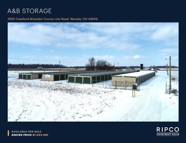


This Property Is For Sale
NEARBY LISTINGS FOR SALE OR LEASE
-
-
View all Nevada listings for sale on LoopNet.com
Property Detail
2935 Crawford Wyandot Rd
Bucyrus, OH
PTSW1/4 BK 1034PG 1508PB 37 P 516
37-0010676.003
Crawford
Publicstorage
Ohio
X
881
39033C0125D
2.62 AC
2025
Ohio North Area
2024
Other Market Areas
974200
DEMOGRAPHICS near 2935 Crawford Wyandot Rd
1 Mile
3 Mile
5 Mile
2024 Total Population
136
1,415
2,682
2029 Population
135
1,401
2,635
Pop Growth 2024-2029
(0.74%)
(0.99%)
(1.75%)
Average Age
41
41
43
2024 Total Households
55
572
1,089
HH Growth 2024-2029
(1.82%)
(0.87%)
(1.74%)
Median Household Inc
$64,285
$62,769
$64,601
Avg Household Size
2.50
2.50
2.40
2024 Avg HH Vehicles
2.00
2.00
2.00
Median Home Value
$99,999
$113,087
$140,251
Median Year Built
1954
1956
1959
Nearby Places
Map Layers
Map Styles
 Street
 Aerial
- Restaurants
- Banks
- Shops
- Fitness
- Groceries
Nearby Properties
Address
Land Use
TOTAL SIZE
Lot Size
Zoning
Address
Land Use
TOTAL SIZE
Lot Size
Zoning
164.73 AC
Address
Land Use
TOTAL SIZE
Lot Size
Zoning
157.83 AC
Address
Land Use
TOTAL SIZE
Lot Size
Zoning
1,092 SF
70 AC
Address
Land Use
TOTAL SIZE
Lot Size
Zoning
158.22 AC
Address
Land Use
TOTAL SIZE
Lot Size
Zoning
155.97 AC
Address
Land Use
TOTAL SIZE
Lot Size
Zoning
125.92 AC
Address
Land Use
TOTAL SIZE
Lot Size
Zoning
Address
Land Use
TOTAL SIZE
Lot Size
Zoning
115.47 AC
Address
Land Use
TOTAL SIZE
Lot Size
Zoning
1,871 SF
117.40 AC
Address
Land Use
TOTAL SIZE
Lot Size
Zoning
118.80 AC
Address
Land Use
TOTAL SIZE
Lot Size
Zoning
83.60 AC
Address
Land Use
TOTAL SIZE
Lot Size
Zoning
Address
Land Use
TOTAL SIZE
Lot Size
Zoning
68.72 AC
Address
Land Use
TOTAL SIZE
Lot Size
Zoning
Address
Land Use
TOTAL SIZE
Lot Size
Zoning
78.32 AC
Address
Land Use
TOTAL SIZE
Lot Size
Zoning
Address
Land Use
TOTAL SIZE
Lot Size
Zoning
79.19 AC
Address
Land Use
TOTAL SIZE
Lot Size
Zoning
160 AC
Address
Land Use
TOTAL SIZE
Lot Size
Zoning
Address
Land Use
TOTAL SIZE
Lot Size
Zoning
Address
Land Use
TOTAL SIZE
Lot Size
Zoning
83.25 AC
Address
Land Use
TOTAL SIZE
Lot Size
Zoning
73.29 AC
Address
Land Use
TOTAL SIZE
Lot Size
Zoning
69.70 AC
Address
Land Use
TOTAL SIZE
Lot Size
Zoning
67.64 AC
Address
Land Use
TOTAL SIZE
Lot Size
Zoning
69.39 AC
Address
Land Use
TOTAL SIZE
Lot Size
Zoning
78.94 AC
Address
Land Use
TOTAL SIZE
Lot Size
Zoning
83.82 AC
Address
Land Use
TOTAL SIZE
Lot Size
Zoning
74.32 AC
Address
Land Use
TOTAL SIZE
Lot Size
Zoning
83.77 AC
Address
Land Use
TOTAL SIZE
Lot Size
Zoning
71.75 AC
The World's #1 Commercial Real Estate Marketplace
Connect with us
© 2025 CoStar Group
The information above has been obtained from sources believed reliable. While we do not doubt its accuracy we have not verified it and make no guarantee, warranty or representation about it. It is your responsibility to independently confirm its accuracy and completeness. Any projections, opinions, assumptions, or estimates used are for example only and do not represent the current or future performance of the property. The value of this transaction to you depends on tax and other factors which should be evaluated by your tax, financial, and legal advisors. You and your advisors should conduct a careful, independent investigation of the property to determine to your satisfaction the suitability of the property for your needs.