Property Record
29350 Pacific Coast Hwy, Malibu, CA 90265


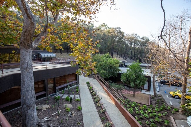
This Property Is For Sale
Current Lease Availabilities
NEARBY LISTINGS FOR SALE OR LEASE
Property Detail
29350 Pacific Coast Hwy
Los Angeles-Long Beach-Glendale, CA
The Rancho Topanga Malibu Sequit
4468-011-005
LAND OF MATTHEW KELLER IN THE RANCHO TOPANGA MALIBU SEQUIT LOT ON SE LINE OF PACIFIC COAST HWY PER FM11260-2 COM SW THEREON 524.10 FT FROM MOST W COR OF LOT 1 R S 57-9-10 TH SW ON SD SE LINE 569 FT FT TO BEG PART OF LOTS 11 AND LOT 12
Officebuilding
Los Angeles
X
California
06037C1514G
12
2024
2.27 AC
2025
Pacific Palisades/Malibu
800412
Los Angeles
13,167 SF
DEMOGRAPHICS near 29350 Pacific Coast Hwy
1 Mile
3 Mile
5 Mile
2024 Total Population
3,345
8,450
11,486
2029 Population
3,418
8,683
11,765
Pop Growth 2024-2029
+ 2.18%
+ 2.76%
+ 2.43%
Average Age
46
47
45
2024 Total Households
1,363
3,363
4,271
HH Growth 2024-2029
+ 1.91%
+ 2.59%
+ 2.69%
Median Household Inc
$173,898
$177,891
$176,009
Avg Household Size
2.40
2.50
2.50
2024 Avg HH Vehicles
2.00
2.00
2.00
Median Home Value
$1,116,020
$1,126,101
$1,127,895
Median Year Built
1977
1977
1977
Nearby Places
Map Layers
Map Styles
 Street
 Aerial
- Restaurants
- Banks
- Shops
- Fitness
- Groceries
PUBLIC TRANSPORTATION
AIRPORT
Los Angeles International
DRIVE
WALK
Distance
Los Angeles International
49 min
28.3 mi
Bob Hope
DRIVE
WALK
Distance
Bob Hope
56 min
40.3 mi
Freight Ports
The Port of Hueneme
DRIVE
WALK
Distance
The Port of Hueneme
36 min
26.3 mi
Nearby Properties
Address
Land Use
TOTAL SIZE
Lot Size
Zoning
Address
Land Use
TOTAL SIZE
Lot Size
Zoning
41,478 SF
13.39 AC
MACC
Address
Land Use
TOTAL SIZE
Lot Size
Zoning
83,298 SF
2.46 AC
LCC3*
Address
Land Use
TOTAL SIZE
Lot Size
Zoning
0.93 AC
LCRA1*
Address
Land Use
TOTAL SIZE
Lot Size
Zoning
64,471 SF
1.30 AC
LCC3*
Address
Land Use
TOTAL SIZE
Lot Size
Zoning
3,354 SF
0.73 AC
LCR3-1*
Address
Land Use
TOTAL SIZE
Lot Size
Zoning
1,050 SF
0.23 AC
LCR171/2
Address
Land Use
TOTAL SIZE
Lot Size
Zoning
5,192 SF
1.03 AC
LCR220000*
Address
Land Use
TOTAL SIZE
Lot Size
Zoning
1.05 AC
LCRA1*
Address
Land Use
TOTAL SIZE
Lot Size
Zoning
0.42 AC
LCR110000*
Address
Land Use
TOTAL SIZE
Lot Size
Zoning
0.39 AC
LUCR110000
Address
Land Use
TOTAL SIZE
Lot Size
Zoning
2.94 AC
LCR111000*
Address
Land Use
TOTAL SIZE
Lot Size
Zoning
30,629 SF
1.62 AC
LCC2*
Address
Land Use
TOTAL SIZE
Lot Size
Zoning
1.22 AC
LCRA1*
Address
Land Use
TOTAL SIZE
Lot Size
Zoning
0.27 AC
LCR110000*
Address
Land Use
TOTAL SIZE
Lot Size
Zoning
3.08 AC
LCR11*
Address
Land Use
TOTAL SIZE
Lot Size
Zoning
2.14 AC
LCRA1*
Address
Land Use
TOTAL SIZE
Lot Size
Zoning
9.87 AC
LCRA1Y
Address
Land Use
TOTAL SIZE
Lot Size
Zoning
13,370 SF
3.95 AC
LCRA1Y
Address
Land Use
TOTAL SIZE
Lot Size
Zoning
15,991 SF
0.43 AC
LCC1-2*
Address
Land Use
TOTAL SIZE
Lot Size
Zoning
1.18 AC
LCRA1*
Address
Land Use
TOTAL SIZE
Lot Size
Zoning
11,854 SF
3.21 AC
LCR3*
Address
Land Use
TOTAL SIZE
Lot Size
Zoning
0.26 AC
LCR110000*
Address
Land Use
TOTAL SIZE
Lot Size
Zoning
0.53 AC
LCRR10
Address
Land Use
TOTAL SIZE
Lot Size
Zoning
0.50 AC
LCRR10
Address
Land Use
TOTAL SIZE
Lot Size
Zoning
0.55 AC
LCRR10
Address
Land Use
TOTAL SIZE
Lot Size
Zoning
0.54 AC
LCRR10
Address
Land Use
TOTAL SIZE
Lot Size
Zoning
1.09 AC
LCA11Y
Address
Land Use
TOTAL SIZE
Lot Size
Zoning
1.08 AC
LCRA1*
Address
Land Use
TOTAL SIZE
Lot Size
Zoning
3,008 SF
0.57 AC
LCRA1*
Address
Land Use
TOTAL SIZE
Lot Size
Zoning
2.57 AC
LCRA20
The World's #1 Commercial Real Estate Marketplace
Connect with us
© 2026 CoStar Group
The information above has been obtained from sources believed reliable. While we do not doubt its accuracy we have not verified it and make no guarantee, warranty or representation about it. It is your responsibility to independently confirm its accuracy and completeness. Any projections, opinions, assumptions, or estimates used are for example only and do not represent the current or future performance of the property. The value of this transaction to you depends on tax and other factors which should be evaluated by your tax, financial, and legal advisors. You and your advisors should conduct a careful, independent investigation of the property to determine to your satisfaction the suitability of the property for your needs.