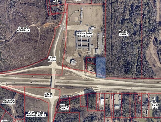
Property Record
2936 Woodward Ave, Ruston, LA 71270

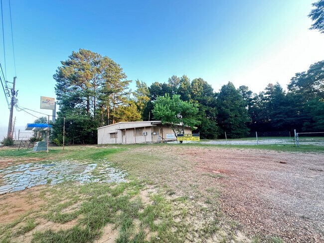
This Property Is For Sale
Property Detail
2936 Woodward Ave
7506
A TRACT IN SE OF SE SEC 16-18-3 DESCR AS: FROM SE/C OF SEC 16 MEASURE N 00 DEG 03 EALONG E LINE OF SEC 16 A DIST OF 16612' TO
Warehouse
LINCOLN
B and X Area of moderate flood hazard, usually the area between the limits of the 100-year and 500-year floods.
Louisiana
2025
2 AC
2025
Louisiana North Area
960300
Other Market Areas
3,200 SF
Ruston, LA
NEARBY LISTINGS FOR SALE OR LEASE
DEMOGRAPHICS near 2936 Woodward Ave
1 mile
3 mile
5 mile
2025 Total Population
1,726
22,129
33,811
2030 Population
1,776
22,171
33,799
Pop Growth 2025-2030
+ 2.90%
+ 0.19%
(0.04%)
Average Age
32
33
34
2025 Total Households
712
7,999
12,319
HH Growth 2025-2030
+ 3.23%
+ 0.24%
(0.03%)
Median Household Inc
$27,368
$31,587
$32,602
Avg Household Size
2.30
2.30
2.30
2025 Avg HH Vehicles
2.00
2.00
2.00
Median Home Value
$274,025
$223,533
$206,704
Median Year Built
1992
1984
1983
Nearby Places
Map Layers
Map Styles
 Street
 Aerial
Transit
 Traffic
 Biking
Places
Listings with unknown addresses are not visible on the map
- Restaurants
- Banks
- Shops
- Fitness
- Groceries
Nearby Properties
Address
Land Use
TOTAL SIZE
Lot Size
Zoning
Address
Land Use
TOTAL SIZE
Lot Size
Zoning
155,626 SF
13.18 AC
Address
Land Use
TOTAL SIZE
Lot Size
Zoning
105,290 SF
11.12 AC
Address
Land Use
TOTAL SIZE
Lot Size
Zoning
206,447 SF
Address
Land Use
TOTAL SIZE
Lot Size
Zoning
17,028 SF
12.28 AC
Address
Land Use
TOTAL SIZE
Lot Size
Zoning
264,355 SF
20.26 AC
Address
Land Use
TOTAL SIZE
Lot Size
Zoning
138,249 SF
4.89 AC
Address
Land Use
TOTAL SIZE
Lot Size
Zoning
31,716 SF
4.99 AC
Address
Land Use
TOTAL SIZE
Lot Size
Zoning
110,675 SF
15.14 AC
Address
Land Use
TOTAL SIZE
Lot Size
Zoning
55,929 SF
3.35 AC
Address
Land Use
TOTAL SIZE
Lot Size
Zoning
13,926 SF
7.94 AC
Address
Land Use
TOTAL SIZE
Lot Size
Zoning
26,838 SF
9.64 AC
Address
Land Use
TOTAL SIZE
Lot Size
Zoning
17,418 SF
11.16 AC
Address
Land Use
TOTAL SIZE
Lot Size
Zoning
25,638 SF
19.33 AC
Address
Land Use
TOTAL SIZE
Lot Size
Zoning
33,140 SF
2.79 AC
Address
Land Use
TOTAL SIZE
Lot Size
Zoning
52,824 SF
2.16 AC
Address
Land Use
TOTAL SIZE
Lot Size
Zoning
58,868 SF
6.46 AC
Address
Land Use
TOTAL SIZE
Lot Size
Zoning
43,738 SF
6.92 AC
Address
Land Use
TOTAL SIZE
Lot Size
Zoning
10,374 SF
6.91 AC
Address
Land Use
TOTAL SIZE
Lot Size
Zoning
34,414 SF
3.87 AC
Address
Land Use
TOTAL SIZE
Lot Size
Zoning
42,672 SF
3.30 AC
Address
Land Use
TOTAL SIZE
Lot Size
Zoning
45,984 SF
2.15 AC
Address
Land Use
TOTAL SIZE
Lot Size
Zoning
14,384 SF
2.07 AC
Address
Land Use
TOTAL SIZE
Lot Size
Zoning
24,300 SF
2.55 AC
Address
Land Use
TOTAL SIZE
Lot Size
Zoning
36,214 SF
2.11 AC
Address
Land Use
TOTAL SIZE
Lot Size
Zoning
88,678 SF
12.31 AC
Address
Land Use
TOTAL SIZE
Lot Size
Zoning
11.68 AC
Address
Land Use
TOTAL SIZE
Lot Size
Zoning
30,801 SF
6.45 AC
Address
Land Use
TOTAL SIZE
Lot Size
Zoning
32,000 SF
4.89 AC
Address
Land Use
TOTAL SIZE
Lot Size
Zoning
56,377 SF
5.18 AC
Address
Land Use
TOTAL SIZE
Lot Size
Zoning
4,200 SF
1.08 AC
The World's #1 Commercial Real Estate Marketplace
Connect with us
© 2026 CoStar Group
The information above has been obtained from sources believed reliable. While we do not doubt its accuracy we have not verified it and make no guarantee, warranty or representation about it. It is your responsibility to independently confirm its accuracy and completeness. Any projections, opinions, assumptions, or estimates used are for example only and do not represent the current or future performance of the property. The value of this transaction to you depends on tax and other factors which should be evaluated by your tax, financial, and legal advisors. You and your advisors should conduct a careful, independent investigation of the property to determine to your satisfaction the suitability of the property for your needs.