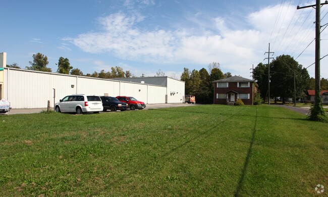
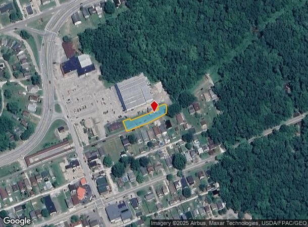
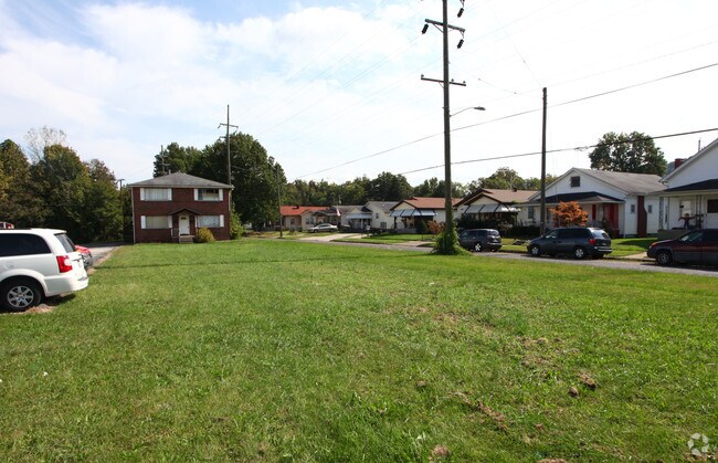
Property Record
2938 Bradley Rd, Huntington, WV 25704
NEARBY LISTINGS FOR SALE OR LEASE
-
-
View all Huntington listings for sale on LoopNet.com
Property Detail
2938 Bradley Rd
06-3-03490006
PARCEL A (.143 AC) LESS O & G (SURVEY)
Gardenaptcourtapt5plusunits
Wayne
X
West Virginia
54099C0020D
0.14 AC
2025
Wayne County
2025
Huntington/Ashland
005200
Huntington-Ashland, WV-KY-OH
DEMOGRAPHICS near 2938 Bradley Rd
1 Mile
3 Mile
5 Mile
2024 Total Population
5,864
23,708
60,697
2029 Population
5,745
23,367
59,769
Pop Growth 2024-2029
(2.03%)
(1.44%)
(1.53%)
Average Age
42
42
40
2024 Total Households
2,662
10,473
25,817
HH Growth 2024-2029
(1.95%)
(1.44%)
(1.43%)
Median Household Inc
$36,089
$43,165
$44,609
Avg Household Size
2.20
2.20
2.20
2024 Avg HH Vehicles
1.00
2.00
2.00
Median Home Value
$80,776
$117,131
$135,044
Median Year Built
1951
1959
1963
Nearby Places
Map Layers
Map Styles
 Street
 Aerial
- Restaurants
- Banks
- Shops
- Fitness
- Groceries
PUBLIC TRANSPORTATION
COMMUTER RAIL
Huntington Amtrak Station (Cardinal - Amtrak)
DRIVE
WALK
Distance
Huntington Amtrak Station (Cardinal - Amtrak)
10 min
4.1 mi
AIRPORT
Tri-State/Milton J Ferguson Field
DRIVE
WALK
Distance
Tri-State/Milton J Ferguson Field
17 min
9.1 mi
Freight Ports
Port of Toledo
DRIVE
WALK
Distance
Port of Toledo
349 min
270.1 mi
Nearby Properties
Address
Land Use
TOTAL SIZE
Lot Size
Zoning
Address
Land Use
TOTAL SIZE
Lot Size
Zoning
93.36 AC
Address
Land Use
TOTAL SIZE
Lot Size
Zoning
Address
Land Use
TOTAL SIZE
Lot Size
Zoning
Address
Land Use
TOTAL SIZE
Lot Size
Zoning
4.05 AC
Address
Land Use
TOTAL SIZE
Lot Size
Zoning
348,219 SF
12 AC
Address
Land Use
TOTAL SIZE
Lot Size
Zoning
0.74 AC
Address
Land Use
TOTAL SIZE
Lot Size
Zoning
48.80 AC
Address
Land Use
TOTAL SIZE
Lot Size
Zoning
Address
Land Use
TOTAL SIZE
Lot Size
Zoning
Address
Land Use
TOTAL SIZE
Lot Size
Zoning
Address
Land Use
TOTAL SIZE
Lot Size
Zoning
Address
Land Use
TOTAL SIZE
Lot Size
Zoning
18,540 SF
4.37 AC
Address
Land Use
TOTAL SIZE
Lot Size
Zoning
11.90 AC
Address
Land Use
TOTAL SIZE
Lot Size
Zoning
26.44 AC
Address
Land Use
TOTAL SIZE
Lot Size
Zoning
7.98 AC
Address
Land Use
TOTAL SIZE
Lot Size
Zoning
Address
Land Use
TOTAL SIZE
Lot Size
Zoning
28.27 AC
Address
Land Use
TOTAL SIZE
Lot Size
Zoning
Address
Land Use
TOTAL SIZE
Lot Size
Zoning
Address
Land Use
TOTAL SIZE
Lot Size
Zoning
Address
Land Use
TOTAL SIZE
Lot Size
Zoning
12.18 AC
Address
Land Use
TOTAL SIZE
Lot Size
Zoning
132,113 SF
4.38 AC
Address
Land Use
TOTAL SIZE
Lot Size
Zoning
4.98 AC
Address
Land Use
TOTAL SIZE
Lot Size
Zoning
3,140 SF
8.34 AC
Address
Land Use
TOTAL SIZE
Lot Size
Zoning
139,404 SF
13.66 AC
Address
Land Use
TOTAL SIZE
Lot Size
Zoning
2.65 AC
Address
Land Use
TOTAL SIZE
Lot Size
Zoning
1.51 AC
Address
Land Use
TOTAL SIZE
Lot Size
Zoning
7,944 SF
5.92 AC
Address
Land Use
TOTAL SIZE
Lot Size
Zoning
37,248 SF
2.12 AC
Address
Land Use
TOTAL SIZE
Lot Size
Zoning
82,101 SF
8.63 AC
The World's #1 Commercial Real Estate Marketplace
Connect with us
© 2025 CoStar Group
The information above has been obtained from sources believed reliable. While we do not doubt its accuracy we have not verified it and make no guarantee, warranty or representation about it. It is your responsibility to independently confirm its accuracy and completeness. Any projections, opinions, assumptions, or estimates used are for example only and do not represent the current or future performance of the property. The value of this transaction to you depends on tax and other factors which should be evaluated by your tax, financial, and legal advisors. You and your advisors should conduct a careful, independent investigation of the property to determine to your satisfaction the suitability of the property for your needs.