Property Record
2939 Defuniak St, New Port Richey, FL 34655

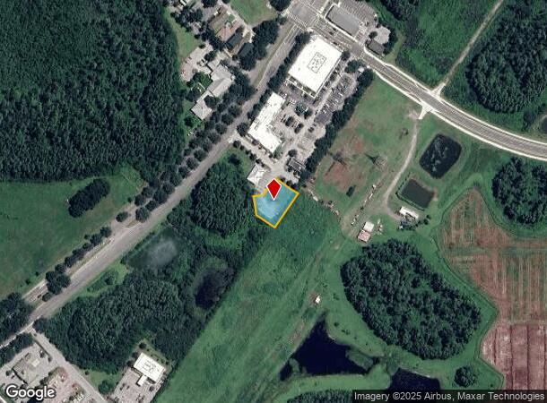
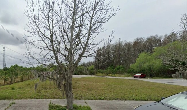
This Property Is For Sale
NEARBY LISTINGS FOR SALE OR LEASE
Property Detail
2939 Defuniak St
Tampa-St. Petersburg-Clearwater, FL
Acreage
30-26-17-0000-00200-0019
COM AT NE COR OF NW1/4 OF SEC TH N88DEG5958W ALG N LN OF NW1/4 271.43/S34DEG0919W 242.31/FOR POB TH S34DEG09 19W 159.04/N55DEG5041W 85.28/N09DEG0645W 64.67/ N31DEG4108W 81.37/TO PT OF INTERSEC ELY R/W STARKEY BLVD N40DEG1224E 81.72/CV L RAD 1060.00/C
Commercialacreage
Pasco
AE
Florida
12101C0360F
19
2024
0.39 AC
2025
Pasco County
031706
Tampa/St Petersburg
DEMOGRAPHICS near 2939 Defuniak St
1 Mile
3 Mile
5 Mile
2024 Total Population
5,790
47,564
102,794
2029 Population
7,038
57,377
123,109
Pop Growth 2024-2029
+ 21.55%
+ 20.63%
+ 19.76%
Average Age
41
44
44
2024 Total Households
2,177
19,225
41,697
HH Growth 2024-2029
+ 21.59%
+ 20.56%
+ 19.71%
Median Household Inc
$98,105
$75,503
$69,360
Avg Household Size
2.70
2.40
2.40
2024 Avg HH Vehicles
2.00
2.00
2.00
Median Home Value
$347,210
$307,560
$287,040
Median Year Built
2003
1999
1992
Nearby Places
- Restaurants
- Banks
- Shops
- Fitness
- Groceries
PUBLIC TRANSPORTATION
AIRPORT
Tampa International
DRIVE
WALK
Distance
Tampa International
40 min
27.1 mi
St Pete-Clearwater International
DRIVE
WALK
Distance
St Pete-Clearwater International
51 min
29.0 mi
Freight Ports
Port of Tampa Bay
DRIVE
WALK
Distance
Port of Tampa Bay
52 min
32.6 mi
Nearby Properties
Address
Land Use
TOTAL SIZE
Lot Size
Zoning
Address
Land Use
TOTAL SIZE
Lot Size
Zoning
420,063 SF
42.64 AC
C2
Address
Land Use
TOTAL SIZE
Lot Size
Zoning
417,700 SF
28.91 AC
MPUD
Address
Land Use
TOTAL SIZE
Lot Size
Zoning
339,446 SF
16.29 AC
MPUD
Address
Land Use
TOTAL SIZE
Lot Size
Zoning
290,535 SF
14.91 AC
MPUD
Address
Land Use
TOTAL SIZE
Lot Size
Zoning
403,054 SF
117.69 AC
MPUD
Address
Land Use
TOTAL SIZE
Lot Size
Zoning
203,571 SF
13.82 AC
C2
Address
Land Use
TOTAL SIZE
Lot Size
Zoning
190,854 SF
14.90 AC
MPUD
Address
Land Use
TOTAL SIZE
Lot Size
Zoning
229,050 SF
36.13 AC
MPUD
Address
Land Use
TOTAL SIZE
Lot Size
Zoning
143,332 SF
17.40 AC
C2
Address
Land Use
TOTAL SIZE
Lot Size
Zoning
152,300 SF
2.82 AC
MF3
Address
Land Use
TOTAL SIZE
Lot Size
Zoning
1,017 AC
AR
Address
Land Use
TOTAL SIZE
Lot Size
Zoning
113,034 SF
15.21 AC
MPUD
Address
Land Use
TOTAL SIZE
Lot Size
Zoning
191,812 SF
17.61 AC
MPUD
Address
Land Use
TOTAL SIZE
Lot Size
Zoning
114,831 SF
7.98 AC
MF2
Address
Land Use
TOTAL SIZE
Lot Size
Zoning
59,874 SF
7.73 AC
MPUD
Address
Land Use
TOTAL SIZE
Lot Size
Zoning
116,607 SF
3.88 AC
MPUD
Address
Land Use
TOTAL SIZE
Lot Size
Zoning
83,958 SF
18.56 AC
MPUD
Address
Land Use
TOTAL SIZE
Lot Size
Zoning
135,600 SF
13.34 AC
MF1
Address
Land Use
TOTAL SIZE
Lot Size
Zoning
80,957 SF
17.71 AC
MPUD
Address
Land Use
TOTAL SIZE
Lot Size
Zoning
70,248 SF
27.90 AC
R4
Address
Land Use
TOTAL SIZE
Lot Size
Zoning
89,242 SF
14.28 AC
MPUD
Address
Land Use
TOTAL SIZE
Lot Size
Zoning
217,376 SF
22.12 AC
C2
Address
Land Use
TOTAL SIZE
Lot Size
Zoning
61,760 SF
11.47 AC
MPUD
Address
Land Use
TOTAL SIZE
Lot Size
Zoning
85,547 SF
16.13 AC
MPUD
Address
Land Use
TOTAL SIZE
Lot Size
Zoning
106,039 SF
3.03 AC
MPUD
Address
Land Use
TOTAL SIZE
Lot Size
Zoning
74,679 SF
5.93 AC
MPUD
Address
Land Use
TOTAL SIZE
Lot Size
Zoning
85,600 SF
13.40 AC
C2
Address
Land Use
TOTAL SIZE
Lot Size
Zoning
89,308 SF
0.58 AC
C2
Address
Land Use
TOTAL SIZE
Lot Size
Zoning
75,844 SF
2.75 AC
C2
The World's #1 Commercial Real Estate Marketplace
Connect with us
© 2025 CoStar Group
The information above has been obtained from sources believed reliable. While we do not doubt its accuracy we have not verified it and make no guarantee, warranty or representation about it. It is your responsibility to independently confirm its accuracy and completeness. Any projections, opinions, assumptions, or estimates used are for example only and do not represent the current or future performance of the property. The value of this transaction to you depends on tax and other factors which should be evaluated by your tax, financial, and legal advisors. You and your advisors should conduct a careful, independent investigation of the property to determine to your satisfaction the suitability of the property for your needs.