Property Record
294 Daniel Webster Hwy, Meredith, NH 03253
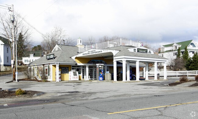

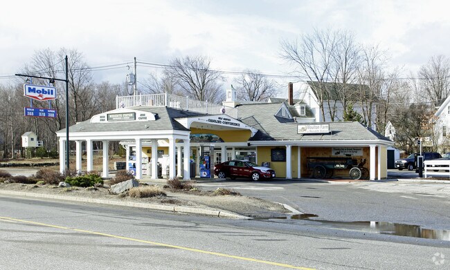
Property Detail
294 Daniel Webster Hwy
MERE-000006U-000108
BELKNAP
Gasolinefuelbulkstorage
New Hampshire
CB
0.26 AC
2025
Concord/New Hampshire North Area
2025
Other Market Areas
965300
Laconia, NH
1,378 SF
NEARBY LISTINGS FOR SALE OR LEASE
-
-
-
No Photo
-
View all Meredith listings for sale on LoopNet.com
DEMOGRAPHICS near 294 Daniel Webster Hwy
1 mile
3 mile
5 mile
2025 Total Population
1,833
6,106
12,496
2030 Population
1,834
6,241
13,124
Pop Growth 2025-2030
+ 0.05%
+ 2.21%
+ 5.03%
Average Age
48
49
50
2025 Total Households
821
2,664
5,647
HH Growth 2025-2030
(0.24%)
+ 2.18%
+ 5.24%
Median Household Inc
$53,125
$90,047
$104,544
Avg Household Size
2.10
2.20
2.10
2025 Avg HH Vehicles
2.00
2.00
2.00
Median Home Value
$493,999
$493,377
$486,229
Median Year Built
1978
1979
1981
Nearby Places
Map Layers
Map Styles
 Street
 Aerial
Transit
 Traffic
 Biking
Places
Listings with unknown addresses are not visible on the map
- Restaurants
- Banks
- Shops
- Fitness
- Groceries
Nearby Properties
Address
Land Use
TOTAL SIZE
Lot Size
Zoning
Address
Land Use
TOTAL SIZE
Lot Size
Zoning
61,304 SF
4.02 AC
CB
Address
Land Use
TOTAL SIZE
Lot Size
Zoning
28.20 AC
R
Address
Land Use
TOTAL SIZE
Lot Size
Zoning
100,579 SF
10.15 AC
CS&S
Address
Land Use
TOTAL SIZE
Lot Size
Zoning
8.91 AC
R
Address
Land Use
TOTAL SIZE
Lot Size
Zoning
3.73 AC
CB
Address
Land Use
TOTAL SIZE
Lot Size
Zoning
28.80 AC
CB
Address
Land Use
TOTAL SIZE
Lot Size
Zoning
29,927 SF
5.70 AC
CB
Address
Land Use
TOTAL SIZE
Lot Size
Zoning
52,555 SF
11.17 AC
CB&R
Address
Land Use
TOTAL SIZE
Lot Size
Zoning
2.41 AC
S
Address
Land Use
TOTAL SIZE
Lot Size
Zoning
15.26 AC
R&FR
Address
Land Use
TOTAL SIZE
Lot Size
Zoning
2.38 AC
S
Address
Land Use
TOTAL SIZE
Lot Size
Zoning
2.10 AC
S
Address
Land Use
TOTAL SIZE
Lot Size
Zoning
21,284 SF
1.06 AC
CB
Address
Land Use
TOTAL SIZE
Lot Size
Zoning
20,564 SF
1.67 AC
CB
Address
Land Use
TOTAL SIZE
Lot Size
Zoning
18,057 SF
3.68 AC
CB&R
Address
Land Use
TOTAL SIZE
Lot Size
Zoning
1,882 SF
1.31 AC
S
Address
Land Use
TOTAL SIZE
Lot Size
Zoning
27,486 SF
35 AC
FR&R
Address
Land Use
TOTAL SIZE
Lot Size
Zoning
3,195 SF
2.25 AC
S
Address
Land Use
TOTAL SIZE
Lot Size
Zoning
7,168 SF
1.39 AC
CB&R
Address
Land Use
TOTAL SIZE
Lot Size
Zoning
752 SF
28.01 AC
S
Address
Land Use
TOTAL SIZE
Lot Size
Zoning
11.23 AC
CB
Address
Land Use
TOTAL SIZE
Lot Size
Zoning
0.73 AC
S
Address
Land Use
TOTAL SIZE
Lot Size
Zoning
1.63 AC
S
Address
Land Use
TOTAL SIZE
Lot Size
Zoning
2.70 AC
S
Address
Land Use
TOTAL SIZE
Lot Size
Zoning
66.73 AC
R
Address
Land Use
TOTAL SIZE
Lot Size
Zoning
7.63 AC
R
Address
Land Use
TOTAL SIZE
Lot Size
Zoning
8.48 AC
BI&R
Address
Land Use
TOTAL SIZE
Lot Size
Zoning
18,194 SF
0.58 AC
CB
Address
Land Use
TOTAL SIZE
Lot Size
Zoning
19,416 SF
2.27 AC
CB
Address
Land Use
TOTAL SIZE
Lot Size
Zoning
14,222 SF
3.01 AC
CB&R
The World's #1 Commercial Real Estate Marketplace
Connect with us
© 2026 CoStar Group
The information above has been obtained from sources believed reliable. While we do not doubt its accuracy we have not verified it and make no guarantee, warranty or representation about it. It is your responsibility to independently confirm its accuracy and completeness. Any projections, opinions, assumptions, or estimates used are for example only and do not represent the current or future performance of the property. The value of this transaction to you depends on tax and other factors which should be evaluated by your tax, financial, and legal advisors. You and your advisors should conduct a careful, independent investigation of the property to determine to your satisfaction the suitability of the property for your needs.