Property Record
294 E Main St, East Brookfield, MA 01515
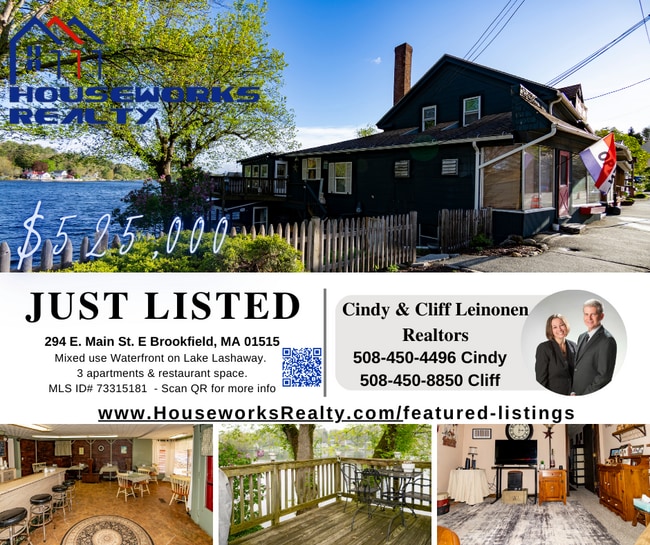


This Property Is For Sale
Property Detail
294 E Main St
EBRO-000042-000130-000360
Worcester
Commercialofficeresidentialmixeduse
Massachusetts
C
360
2025
0.11 AC
2025
Outlying Worcester
759100
Boston
3,534 SF
Worcester, MA
NEARBY LISTINGS FOR SALE OR LEASE
DEMOGRAPHICS near 294 E Main St
1 mile
3 mile
5 mile
2025 Total Population
1,431
8,094
23,464
2030 Population
1,472
8,243
24,067
Pop Growth 2025-2030
+ 2.87%
+ 1.84%
+ 2.57%
Average Age
43
44
44
2025 Total Households
566
3,422
9,825
HH Growth 2025-2030
+ 3.00%
+ 1.90%
+ 2.64%
Median Household Inc
$84,615
$74,725
$80,980
Avg Household Size
2.50
2.40
2.40
2025 Avg HH Vehicles
2.00
2.00
2.00
Median Home Value
$399,290
$385,543
$385,536
Median Year Built
1959
1960
1969
Nearby Places
Map Layers
Map Styles
 Street
 Aerial
Layers
 Traffic
 Biking
Places
Listings with unknown addresses are not visible on the map
- Restaurants
- Banks
- Shops
- Fitness
- Groceries
PUBLIC TRANSPORTATION
AIRPORT
Worcester Regional
Drive
Walk
Distance
Worcester Regional
29 min
13.3 mi
Bradley International
Drive
Walk
Distance
Bradley International
85 min
49.7 mi
Freight Ports
Port of Davisville, RI
Drive
Walk
Distance
Port of Davisville, RI
101 min
72.0 mi
Nearby Properties
Address
Land Use
TOTAL SIZE
Lot Size
Zoning
Address
Land Use
TOTAL SIZE
Lot Size
Zoning
141,180 SF
29.33 AC
Address
Land Use
TOTAL SIZE
Lot Size
Zoning
104,040 SF
17.14 AC
V
Address
Land Use
TOTAL SIZE
Lot Size
Zoning
31,680 SF
6 AC
C
Address
Land Use
TOTAL SIZE
Lot Size
Zoning
81,001 SF
11 AC
Address
Land Use
TOTAL SIZE
Lot Size
Zoning
25,000 SF
22.13 AC
C
Address
Land Use
TOTAL SIZE
Lot Size
Zoning
59,508 SF
1.84 AC
Address
Land Use
TOTAL SIZE
Lot Size
Zoning
1,092 SF
35.26 AC
Address
Land Use
TOTAL SIZE
Lot Size
Zoning
127.62 AC
R
Address
Land Use
TOTAL SIZE
Lot Size
Zoning
5,128 SF
43.47 AC
Address
Land Use
TOTAL SIZE
Lot Size
Zoning
20,700 SF
1.37 AC
BA
Address
Land Use
TOTAL SIZE
Lot Size
Zoning
6,656 SF
2.26 AC
Address
Land Use
TOTAL SIZE
Lot Size
Zoning
20,255 SF
4.23 AC
Address
Land Use
TOTAL SIZE
Lot Size
Zoning
4,285 SF
0.98 AC
Address
Land Use
TOTAL SIZE
Lot Size
Zoning
53,197 SF
12.78 AC
Address
Land Use
TOTAL SIZE
Lot Size
Zoning
5,044 SF
15.93 AC
IN
Address
Land Use
TOTAL SIZE
Lot Size
Zoning
Address
Land Use
TOTAL SIZE
Lot Size
Zoning
34,368 SF
12.50 AC
RR
Address
Land Use
TOTAL SIZE
Lot Size
Zoning
12,969 SF
1.47 AC
Address
Land Use
TOTAL SIZE
Lot Size
Zoning
50,000 SF
53.70 AC
Address
Land Use
TOTAL SIZE
Lot Size
Zoning
12,240 SF
0.41 AC
Address
Land Use
TOTAL SIZE
Lot Size
Zoning
15,847 SF
1.03 AC
Address
Land Use
TOTAL SIZE
Lot Size
Zoning
522.88 AC
66
Address
Land Use
TOTAL SIZE
Lot Size
Zoning
11,326 SF
1.61 AC
Address
Land Use
TOTAL SIZE
Lot Size
Zoning
64,568 SF
25.09 AC
IN
Address
Land Use
TOTAL SIZE
Lot Size
Zoning
20,736 SF
6 AC
Address
Land Use
TOTAL SIZE
Lot Size
Zoning
25,217 SF
2.20 AC
C
Address
Land Use
TOTAL SIZE
Lot Size
Zoning
10,986 SF
0.72 AC
V
Address
Land Use
TOTAL SIZE
Lot Size
Zoning
9,199 SF
1.68 AC
Address
Land Use
TOTAL SIZE
Lot Size
Zoning
1,164 SF
5.11 AC
C
Address
Land Use
TOTAL SIZE
Lot Size
Zoning
16,082 SF
4.20 AC
R
The World's #1 Commercial Real Estate Marketplace
Connect with us
© 2026 CoStar Group
The information above has been obtained from sources believed reliable. While we do not doubt its accuracy we have not verified it and make no guarantee, warranty or representation about it. It is your responsibility to independently confirm its accuracy and completeness. Any projections, opinions, assumptions, or estimates used are for example only and do not represent the current or future performance of the property. The value of this transaction to you depends on tax and other factors which should be evaluated by your tax, financial, and legal advisors. You and your advisors should conduct a careful, independent investigation of the property to determine to your satisfaction the suitability of the property for your needs.